
Alterswilen
| Alterswilen | ||
|---|---|---|
 |
||
| State : |
|
|
| Canton : |
|
|
| District : | Kreuzlingen | |
| Political community : | Kemmental | |
| Postal code : | 8573 | |
| former BFS no. : | 4631 | |
| Coordinates : | 729 091 / 274 748 | |
| Height : | 520 m above sea level M. | |
| Area : | 2.28 km² (local parish) 16.44 km² (pol. Parish) |
|
| Residents: | 253 (December 31, 2018) | |
| Population density : | 111 inhabitants per km² | |
 The Reformed Church in Alterswilen |
||
| map | ||
|
||

Alterswilen is a former local and municipal municipality and a village in the municipality of Kemmental in the Swiss canton of Thurgau . Alterswilen is the church and school center of the Kemmental.
The municipal community, which existed from 1803 to 1995, comprised the local communities of Alterswilen, Altishausen , Ellighausen , Lippoldswilen , Neuwilen and Siegershausen and until 1984 the local community of Dippishausen-Oftershausen, which was incorporated into Siegershausen . In 1996 these communities united with the Munizipalgemeinde Hugelshofen and their two local communities to form the Political Community of Kemmental.
geography
The local community of Alterswilen comprised the parish village of Alterswilen and the hamlet of Bommen. Alterswilen is located on the southern slope of the Seerücken, southwest of Lake Constance .
history


Historically, Alterswilen can be traced back to the year 1248 (decima in Alterswilaer) . The hamlet of Bommen has been documented as Boumen since 1348 . The municipality was originally in the Konstanz Bischofshöri . From the middle of the 13th century to 1798, Alterswilen belonged to the Eggen bailiwick , but Bommen belonged to the Siegershausen court and thus to the episcopal upper bailiwick of Gottlieben .
Initially part of the church after St. Stephan in Konstanz, Alterswilen appeared around 1155 as a branch of Tägerwilen and in 1275 as an independent parish with the church of St. Agatha. The patronage rights came in 1350 from Provost Diethelm von Steinegg and knight Heinrich von Klingenberg to the cathedral chapter of Constance . After the Reformation in 1529, the few Catholics went to church in Bernrain . Since 1831 they belong to the parish of Emmishofen .
In the 19th century, the transition from growing grain in three tents to cattle and dairy farming took place. The Agricultural Association was established in 1895. In connection with the amalgamation of goods from 1967 to 1887, the Bommer Weiher , which was created around 1460 as mill and fish ponds, was placed under nature protection. In 1960, drilling for oil north of it was unsuccessful. Alterswilen has been a secondary school district since 1897 and an upper level district since 1982 .
→ see also: Sections history in the articles about the individual previous local churches
population
| 1850 | 1888 | 1920 | 1930 | 1960 | 1970 | 1990 | 2000 | 2010 | 2018 | |
|---|---|---|---|---|---|---|---|---|---|---|
| Municipal parish | 1281 | 1283 | 1184 | 1185 | 1295 | |||||
| Local parish | 129 | 186 | 134 | 182 | ||||||
| Locality | 197 | 192 | 253 | |||||||
| source | ||||||||||
Of the total of 253 inhabitants in the village of Alterswilen in 2018, 52 or 20.6% were foreign nationals. 132 (52.2%) were Protestant Reformed and 47 (18.6%) were Roman Catholic.
Elementary school
The Kemmental secondary school introduced the cooperative upper school model in the 2003/04 school year after the system had been tested in a class. The students are divided into individual subjects according to performance levels. They attend the other subjects in their regular class.
Attractions
- Alterwilen Reformed Church
- Bommer Weiher : The Bommer Weiher was artificially created around 1460 as a water reservoir to drive mills. Over the centuries, they increasingly silted up and in 1979 had to be partly re-excavated with excavators. The ponds are under nature protection .

Half-timbered in Alterswilen

Alterswilen, Säntis in the background

Ponderous
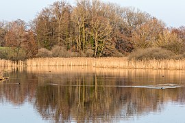
Lower Bommer pond


Web links
Individual evidence
- ↑ a b Swiss land use statistics. Completed on July 1, 1912. Published by the Federal Statistical Bureau. ( Memento from April 12, 2016 in the Internet Archive )
- ↑ a b c d Localities and their resident population. Edition 2019 . On the website of the Statistical Office of the Canton of Thurgau (Excel table; 0.1 MB), accessed on April 28, 2020.
- ↑ Alterswilen. On the website of the Kemmental municipality, accessed on December 8, 2019
- ↑ Population development of the municipalities. Canton of Thurgau, 1850-2000. On the website of the Statistical Office of the Canton of Thurgau (Excel table; 0.1 MB), accessed on April 28, 2020.
-
↑ a b c d André Salathé: Alterswilen. In: Historical Lexicon of Switzerland .
These sections are largely based on the entry in the Historical Lexicon of Switzerland (HLS), which, according to the HLS's usage information, is under the Creative Commons license - Attribution - Share under the same conditions 4.0 International (CC BY-SA 4.0). - ↑ Locations and Settlements Directory. Canton of Thurgau, 2005 edition . On the website of the Statistical Office of the Canton of Thurgau (PDF; 1.7 MB), accessed on April 28, 2020.
- ↑ Locations and Settlements Directory. Canton of Thurgau, 2012 edition. On the website of the Statistical Office of the Canton of Thurgau (PDF; 3.4 MB), accessed on May 11, 2020.
- ↑ Organizational matters . On the website of the Office for Elementary Schools of the Canton of Thurgau, accessed on February 27, 2019
Remarks
- ↑ with outside courtyards
Altnau | Bottigh furnace | Ermatingen | Love God | Güttingen | Kemmental | Kreuzlingen | Langrickenbach | Lengwil | Münsterlingen | Raperswilen | Salenstein | Tägerwilen | Waldi
Former parishes: Alterswilen | Altishausen | Dippishausen-Oftershausen | Dot night | Dünnershaus | Egelshofen | Ellighausen | Emmishofen | Engwilen | Fruthwilen | Hattenhausen-Hefenhausen | Manor | Hugelshofen | Illighausen | Kurzrickenbach | Land battle | Lipperswil | Lippoldswilen | Mannenbach | Neuwilen | Oberhofen near Kreuzlingen | Joking | Schönenbaumgarten | Siegershausen | Sonterswil | Triboltingen | Zuben
Canton of Thurgau | Districts of the Canton of Thurgau | Municipalities of the Canton of Thurgau