
Tägerwilen
| Tägerwilen (with Tägermoos ) |
|
|---|---|
 |
|
| State : |
|
| Canton : |
|
| District : | Kreuzlingen |
| BFS no. : | 4696 |
| Postal code : | 8274 |
| UN / LOCODE : | CH TWN |
| Coordinates : | 727 163 / 279695 |
| Height : | 420 m above sea level M. |
| Height range : | 394–573 m above sea level M. |
| Area : | 11.56 km² |
| Residents: | 4642 (December 31, 2018) |
| Population density : | 402 inhabitants per km² |
|
Proportion of foreigners : (residents without citizenship ) |
36.2% |
| Mayor : | Markus Thalmann |
| Website: | www.taegerwilen.ch |
 Tägerwilen, towards the north |
|
| Location of the municipality | |
  |
|
Tägerwilen (formerly also Taegerweilen or Tägerweilen written) is a political municipality and a village in the district of Kreuzlingen in the canton of Thurgau in Switzerland . Until 2002 Tägerwilen was a unified municipality .
Geography and traffic

The municipality borders on Kreuzlingen , Wäldi , Ermatingen and Gottlieben , also on the Seerhein , which connects the Obersee with the Untersee , and with the Tägermoos on Konstanz. The Dorfbach flows through Tägerwilen , which takes in the Allmendbach from the left.
The village was built on the road between Konstanz and Ermatingen . Today the main roads 13 and 16 cross in Tägerwilen. The lake line and the Mittelthurgau Railway Wil – Kreuzlingen , which is now operated by Thurbo, run through the village . Tägerwilen is also connected to public transport with the 907 bus from the city of Kreuzlingen and the 920 Postbus.
history

Traces of a Neolithic settlement from around 4000 BC were found in Tägerwilen . In the seventh or eighth century , the Alemanni settled in Tägerwilen on the village streams near the Roman road from Konstanz to Winterthur . The first documentary mention comes from the year 990 as Tegirwilare . The history of Tägerwilen is closely linked to that of neighboring Constance. Officials of the Bishop of Constance also founded the castle and the Castell Castle, which was later built next to it.
In the early Middle Ages , Tägerwilen belonged to the Konstanzer Bischofshöri , from around 1300 mainly to the Castell reign . Girsberg Castle was also part of Tägerwilen until 1816 . The opening of 1447 names a separate court. During the Swabian War in 1499 and after the battle in Schwaderloh , the village was burned down and Castell Castle was destroyed. Thereafter, the rulership with the court Siegershausen formed the bailiwick of Gottlieben . The free seats Castell, Girsberg, Hochstrass, Hertler, Okenfiner and Pflanzberg themselves had lower jurisdiction , from 1766 only Castell and Girsberg Castle.

The parish of Tägerwilen left the episcopal area very early - around 900, but documented only from the 12th century. The church with the patronage of Kosmas and Damian was rebuilt in 1455, the beguinage dates from the 14th and 15th centuries. During the Reformation in 1528 the whole village, together with Constance, converted to the new faith. Nevertheless, the collature remained with the Bishop of Constance.
In addition to agriculture and cattle breeding, viticulture and fruit growing were also carried out; the large community forest was important. In Tägerwilen there were nine mills, an infirmary and from around 1610 a school. The von Scherer family at Castell Castle founded a girls' work school in 1801 and the first cantonal toddler school in 1837. In 1822 it also financed the construction and operation of a poor house. After the opening of the Etzwilen – Konstanz railway lines in 1875 and Konstanz – Wil 1911, the village expanded in the direction of the railway stations. At the end of the 19th century, numerous commercial operations were set up, including an automobile manufacturer. In 2005 industry and trade provided a quarter of the jobs in the municipality, while agriculture still provided 10%.
The municipality Tägerwilen also manages the Tägermoos , a constitutional oddity: the 1.54 square kilometers are indeed in the canton of Thurgau, however, are by a treaty of 1831 as a district of the German border town of Konstanz assigned. The figures given for the area and population of Tägerwilen also contain the figures for the Tägermoos.
coat of arms
Blazon : In red a white dagger with a black handle.
The municipal coat of arms has been used since the beginning of the 17th century. Red and white are reminiscent of the Bishop of Constance, who owned the village until 1798.
population
 |
| year | 1634 | 1695 | 1850 | 1900 | 1950 | 1980 | 1990 | 2000 | 2010 | 2018 |
| Residents | 482 | 611 | 1192 | 1188 | 1516 | 2224 | 2618 | 3273 | 3926 | 4635 |
| source | ||||||||||
Of the total of 4635 inhabitants in the municipality of Tägerwilen in 2018, 1678 or 36.2% were foreign nationals. 1664 (35.9%) were Protestant Reformed and 1295 (27.9%) were Roman Catholic. The village of Tägerwilen had 4571 residents at that time. 64 people lived in the village of Kreuzlingen, which spills over the municipal boundary into Tägerwil territory.
economy
In 2016, Tägerwilen offered work for 2,996 people (converted to full-time positions). 3.6% of them were employed in agriculture and forestry, 19.3% in industry, trade and construction and 77.1% in the service sector.
Attractions
Above the town of Tägerwilen are the Ober-Castell Castle and the Unter-Castell ruins .
The current appearance of Castell Castle , which is privately owned, was created between 1878 and 1894 by Max von Scherer. It was built in 1725 instead of an older building from 1585, which in turn replaced an older structure. The castle - one of the most important historicist castle complexes in Switzerland - stands opposite the ruins of the 12th century Castell castle, which was built by the Constance Bishop Ulrich I of Kyburg-Dillingen as the seat of the Ministerial Schenk von Castell . The castle was destroyed by the Confederates during the Swabian War in 1499 .
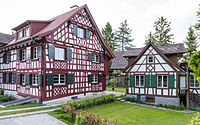
photos

Tägerwilen, behind Konstanz
Unterdorfstrasse

Church in Tägerwilen

Hinterdorfstrasse

Meierhofstrasse

Okenfinerhaus


.jpg)

Personalities
- Johannes Hippenmeyer (1779–1854), officer, Thurgau Cantonal Councilor, owner of Gottlieben Castle
- Johann Konrad Egloff (1808–1886), farmer, politician, officer
- Elise Egloff (1821–1848), literary role model
- Hermann Müller-Thurgau (1850–1927), botanist
- Ernst Kreidolf (1863–1956), children's book illustrator
- Heinrich Ammann (1914–2003), teacher, art historian and museum curator
- Sieglinde Ammann (* 1946), track and field athlete, Olympic participant
literature
- Peter Giger, Erich König, Margrit Surber: Tägerwilen - A Thurgau village through the ages . Tägerwilen 1999.
- Paul Bär: Tägerwilen - A look into the past. Kreuzlingen 1988.
- Regine Abegg, Peter Erni, Alfons Raimann: The art monuments of the canton of Thurgau, Volume VIII: Around Kreuzlingen. (= Art Monuments of Switzerland. Volume 125). Edited by the Society for Swiss Art History GSK. Bern 2014, ISBN 978-3-03797-116-1 , pp. 316–387.
Web links
Individual evidence
- ↑ Permanent and non-permanent resident population by year, canton, district, municipality, population type and gender (permanent resident population). In: bfs. admin.ch . Federal Statistical Office (FSO), August 31, 2019, accessed on December 22, 2019 .
- ↑ a b Thurgau in figures 2019 . On the website of the Statistical Office of the Canton of Thurgau (PDF file; 1.8 MB), accessed on April 28, 2020.
- ↑ a b Localities and their resident population. Edition 2019 . On the website of the Statistical Office of the Canton of Thurgau (Excel table; 0.1 MB), accessed on April 28, 2020.
- ↑ a b c municipal coat of arms . On the website of the State Archives of the Canton of Thurgau, accessed on December 8, 2019
-
↑ a b c d Peter Giger: Tägerwilen. In: Historical Lexicon of Switzerland .
These sections are largely based on the entry in the Historical Lexicon of Switzerland (HLS), which, according to the HLS's usage information, is under the Creative Commons license - Attribution - Share under the same conditions 4.0 International (CC BY-SA 4.0). - ↑ a b Population development of the municipalities. Canton Thurgau, 1850–2000 and resident population of the municipalities and change from the previous year. Canton of Thurgau, 1990–2018. On the website of the Statistical Office of the Canton of Thurgau (Excel tables; 0.1 MB each), accessed on April 28, 2020.
Altnau | Bottigh furnace | Ermatingen | Love God | Güttingen | Kemmental | Kreuzlingen | Langrickenbach | Lengwil | Münsterlingen | Raperswilen | Salenstein | Tägerwilen | Waldi
Former parishes: Alterswilen | Altishausen | Dippishausen-Oftershausen | Dot night | Dünnershaus | Egelshofen | Ellighausen | Emmishofen | Engwilen | Fruthwilen | Hattenhausen-Hefenhausen | Manor | Hugelshofen | Illighausen | Kurzrickenbach | Land battle | Lipperswil | Lippoldswilen | Mannenbach | Neuwilen | Oberhofen near Kreuzlingen | Joking | Schönenbaumgarten | Siegershausen | Sonterswil | Triboltingen | Zuben
Canton of Thurgau | Districts of the Canton of Thurgau | Municipalities of the Canton of Thurgau