
Waldi
| Waldi | |
|---|---|
 |
|
| Country: |
|
| Canton : | Thurgau (TG) |
| District : | Kreuzlingen |
| Postal code : | 8564 |
| BFS no. : | 4701 (Political Community) |
| former BFS no .: | 4704 (local parish ) |
| Coordinates : | 723605 / 277148 |
| Height : | 610 m above sea level M. |
| Area : | 12.21 km² (Pol. Municipality) 2.02 km² (local municipality) |
| Residents: | 1059 (December 31, 2018) |
| Population density : | 87 inhabitants per km² |
| Website: | www.www.waeldi.ch |
 View from the east to Waldi |
|
| map | |
  |
|
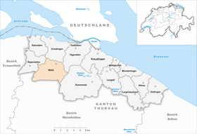
Wäldi is a municipality and a town in the district of Kreuzlingen in the canton of Thurgau in Switzerland .
From 1803 to 1994 the local communities Wäldi, Engwilen , Lipperswil and Sonterswil formed the municipal community Wäldi. Today's political municipality was created on January 1, 1995 from the amalgamation of the municipal municipality of Wäldi with its four local communities.
geography
Wäldi is located on the southern slope of the Seerücken off the Müllheim - Tägerwilen road . The municipality also includes the villages of Engwilen , Gunterswilen (75 inhabitants in 2018), Hattenhausen (72 inh.), Hefenhausen (92 in.), Lipperswil and Sonterswil . The municipal administration is located in Hefenhausen.
The A7 Winterthur – Kreuzlingen motorway runs through the community, but Wäldi does not have its own motorway access.
history
Prehistoric settlement Hohenrain
The Wäldi Hohenrain site was scientifically investigated for the first time in 1931. From 1955, the brick built mountain there mica sand , which is why the objects in a 1972/73 emergency excavation rescued had. The 33,000 ceramic shards come from the Middle Bronze and Hallstatt Ages . Since the Hallstatt period almost overlaid the entire Middle Bronze Age layer, the layers could not be stratigraphically separated. Probably the largest Middle Bronze Age mine complex in the northern Alpine foothills is close to the tumulus culture in Hegau and the Danube Valley (14th century BC). The ceramics of the younger phase were mainly dated to the 7th century BC.
Middle Ages and Modern Times

Wäldi was first mentioned in 1273 as Weldú . In the Middle Ages the clearing settlement Wäldi was outside the episcopal-Constantine immunity area , but the forest near Wäldi is said to have corresponded to the so-called chamber wood of the bishop. Bishop Eberhard von Waldburg acquired the Wäldi farm in 1273 by swap; his successor Rudolf von Habsburg-Laufenburg lived there in 1282. From 1460 to 1798, Wäldi was part of the jurisdiction of the Thurgau governor as a so-called high court . The community letter dates from 1627.
Waldi was parish partly to Ermatingen , partly to Wigoltingen . Until the construction of their own church in 1723, the Reformed church visited Lipperswil, with which Wäldi was still connected as a branch at the beginning of the 21st century . In 1949 Gunterswilen and Hohenrain came from Ermatingen to the parish of Wäldi. The Catholics have belonged to the parish of Ermatingen since the 19th century.
Grain was grown in three tents in Wäldi , along with fruit growing and cattle breeding and, from the second half of the 19th century, dairy farming. The dairy opened in 1862, the milk supply cooperative with cheese dairy in 1887. Wäldi has extensive forests. Around 1900 embroidery offered homework a job. From 1969 to 1989 the goods were amalgamated. In 1995 there was some trade, pig fattening and cattle trading. The high school students attend the school in Tägerwilen . Some newcomers live in small single-family homes.
→ see also the history sections in the articles Engwilen , Lipperswil and Sonterswil
coat of arms
Blazon : In white a red lion head turned right.
The coat of arms commemorates Bishop Eberhard von Waldburg and his successor Rudolf von Habsburg-Laufenburg. The lion's head is for this Habsburg-Laufenburger , the colors are those of the Diocese of Constance . The coat of arms used by the former local community of Wäldi since 1954 is still used by the political community of Wäldi, established in 1995.
population
 |
| 1831 | 1850 | 1900 | 1950 | 1990 | 2000 | 2010 | 2018 | |
|---|---|---|---|---|---|---|---|---|
| Political community | 970 | 987 | 1061 | |||||
| Municipal parish | 921 | 861 | 818 | 789 | ||||
| Local parish | 157 | 220 | 223 | 189 | 190 | |||
| source | ||||||||
Of the total of 1,061 inhabitants in the municipality of Wäldi in 2018, 205 or 19.3% were foreign nationals. 456 (42.10%) were Protestant Reformed and 238 (22.4%) were Roman Catholic. At that time, the village of Wäldi had 335 residents.
economy
In 2016, Wäldi offered 328 jobs (converted to full-time positions). Of these, 24.9% were employed in agriculture and forestry, 13.3% in industry, trade and construction and 61.8% in the service sector.
Attractions
In May 2017, the Napoleon Tower, a 40 meter high observation tower, was opened on the Hohenrain (623 m above sea level ) above the village of Wäldi , whose name is reminiscent of a Belvedere at the time of Prince Louis Napoléon. The Conny-Land amusement park in Lipperswil is well known.
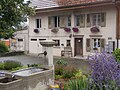
Well and house on Dorfstrasse in Wäldi

Church of Lipperswil
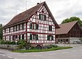
Half-timbered farmhouse in Lipperswil

Waldi community center in Hefenhausen

Conny-Land amusement park
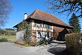
Farmhouse in Sonterswil

Hattenhausen

Aerial photo from May 21, 2010


_169.JPG)
_komunuma_domo_155.JPG)


literature
- Regine Abegg, Peter Erni, Alfons Raimann: The art monuments of the canton of Thurgau, Volume VIII: Around Kreuzlingen. (= Art Monuments of Switzerland. Volume 125). Edited by the Society for Swiss Art History GSK. Bern 2014, ISBN 978-3-03797-116-1 , pp. 388-414.
Web links
Individual evidence
- ↑ a b Thurgau in figures 2019 . On the website of the Statistical Office of the Canton of Thurgau (PDF file; 1.8 MB), accessed on April 28, 2020.
- ↑ Swiss land use statistics. Completed on July 1, 1912. Published by the Federal Statistical Bureau. ( Memento from April 12, 2016 in the Internet Archive )
- ↑ Permanent and non-permanent resident population by year, canton, district, municipality, population type and gender (permanent resident population). In: bfs. admin.ch . Federal Statistical Office (FSO), August 31, 2019, accessed on December 22, 2019 .
- ↑ a b c Localities and their resident population. Edition 2019 . On the website of the Statistical Office of the Canton of Thurgau (Excel table; 0.1 MB), accessed on April 28, 2020.
-
↑ a b c d e Erich Trösch: Wäldi. In: Historical Lexicon of Switzerland .
These sections are largely based on the entry in the Historical Lexicon of Switzerland (HLS), which, according to the HLS's usage information, is under the Creative Commons license - Attribution - Share under the same conditions 4.0 International (CC BY-SA 4.0). - ↑ a b municipal coat of arms . On the website of the State Archives of the Canton of Thurgau, accessed on December 8, 2019
- ↑ a b Population development of the municipalities. Canton Thurgau, 1850–2000 and resident population of the municipalities and change from the previous year. Canton of Thurgau, 1990–2018. On the website of the Statistical Office of the Canton of Thurgau (Excel tables; 0.1 MB each), accessed on April 28, 2020.
Altnau | Bottigh furnace | Ermatingen | Love God | Güttingen | Kemmental | Kreuzlingen | Langrickenbach | Lengwil | Münsterlingen | Raperswilen | Salenstein | Tägerwilen | Waldi
Former parishes: Alterswilen | Altishausen | Dippishausen-Oftershausen | Dot night | Dünnershaus | Egelshofen | Ellighausen | Emmishofen | Engwilen | Fruthwilen | Hattenhausen-Hefenhausen | Manor | Hugelshofen | Illighausen | Kurzrickenbach | Land battle | Lipperswil | Lippoldswilen | Mannenbach | Neuwilen | Oberhofen near Kreuzlingen | Joking | Schönenbaumgarten | Siegershausen | Sonterswil | Triboltingen | Zuben
Canton of Thurgau | Districts of the Canton of Thurgau | Municipalities of the Canton of Thurgau