
Kreuzlingen district
| Kreuzlingen district | |
|---|---|
| Basic data | |
| Country: |
|
| Canton : |
|
| Main town : | Kreuzlingen |
| FSO number : | 2013 |
| Area : | 129.17 km² |
| Height range : | 394–722 m above sea level M. |
| Residents: | 48,345 (December 31, 2018) |
| Population density : | 374 inhabitants per km² |
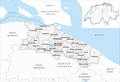
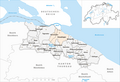
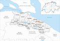
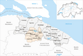
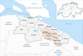
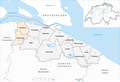
| map | |
 |
|
Kreuzlingen is a district in the canton of Thurgau . The main town is Kreuzlingen .
From 1798 to 1874 Gottlieben was the district capital.
Political communities
The following municipalities belong to the district:
As of January 1, 2011
| coat of arms | Name of the parish | Population (December 31, 2018) |
Area in km² |
Inhabitant per km² |
|---|---|---|---|---|
|
|
Altnau | 2244 | 6.73 | 333 |
|
|
Bottigh furnace | 2226 | 2.41 | 924 |
|
|
Ermatingen | 3455 | 10.46 | 330 |
|
|
Love God | 340 | 0.31 | 1097 |
|
|
Güttingen | 1591 | 9.54 | 167 |
|
|
Kemmental | 2545 | 25.04 | 102 |
|
|
Kreuzlingen | 22,004 | 11.50 | 1913 |
|
|
Langrickenbach | 1291 | 10.83 | 119 |
|
|
Lengwil | 1734 | 8.89 | 195 |
|
|
Munsterlingen | 3476 | 5.46 | 637 |
|
|
Raperswilen | 415 | 7.69 | 54 |
|
|
Salenstein | 1323 | 6.54 | 202 |
|
|
Tägerwilen | 4642 | 11.56 | 402 |
|
|
Waldi | 1059 | 12.21 | 87 |
| Total (14) | 48,345 | 129.17 | 374 | |
Changes in the community

Municipalities until 1873
Municipalities until 1899

Municipalities until 1926
Municipalities until 1927

Municipalities until 1952

Municipalities until 1974

Municipalities until 1983
Municipalities until 1993

Municipalities until 1994
Municipalities until 1995
Municipalities until 1997
Municipalities until 2010


- 1874: Change of name from Egelshofen → Kreuzlingen
- 1900: Change of name from Oftershausen → Dippishausen
- 1927: Fusion of Kreuzlingen and Kurzrickenbach → Kreuzlingen
- 1928: Merger of Emmishofen and Kreuzlingen → Kreuzlingen
- 1953: Change of name from Dippishausen → Dippishausen-Oftershausen
- 1975: Merger of Ermatingen and Triboltingen → Ermatingen
- 1984: Dippishausen-Oftershausen and Siegershausen → Siegershausen merger
- 1994: Merger of Landschlacht and Scherzingen → Münsterlingen
- 1995: Merger of Engwilen , Lipperswil , Sonterswil and Wäldi → Wäldi
- 1996: Merger of Alterswilen , Altishausen , Dotnacht , Ellighausen , Hugelshofen , Lippoldswilen , Neuwilen and Siegershausen → Kemmental
- 1998: Merger of Illighausen and Oberhofen near Kreuzlingen → Lengwil
- 1998: Merger of Dünnershaus , Herrenhof , Langrickenbach , Schönenbaumgarten and Zuben → Langrickenbach
- 2011: District change Raperswilen and Salenstein from the former Steckborn district → Kreuzlingen district
Day moss
In the Kreuzlingen district, in the area of the political municipality of Tägerwilen , there is also the Tägermoos , which, although on Swiss territory, is a district of the city of Konstanz . It is managed jointly by Konstanz and Tägerwilen.
See also
Web links
Individual evidence
- ↑ Permanent and non-permanent resident population by year, canton, district, municipality, population type and gender (permanent resident population). In: bfs. admin.ch . Federal Statistical Office (FSO), August 31, 2019, accessed on December 22, 2019 .
- ↑ Verena Rothenbühler: Gottlieben. In: Historical Lexicon of Switzerland .
- ↑ Federal Statistical Office Generalized Limits 2020.
Arbon | Frauenfeld | Kreuzlingen | Münchwilen | Weinfelden
Former districts: Bischofszell | Diessenhofen | Steckborn
Canton of Thurgau | Districts of Switzerland | Municipalities of the Canton of Thurgau