
Arbon district
| Arbon district | |
|---|---|
| Basic data | |
| Country: |
|
| Canton : |
|
| Main town : | Arbon |
| FSO number : | 2011 |
| Area : | 89.07 km² |
| Height range : | 394-598 m above sea level M. |
| Residents: | 56,638 (December 31, 2018) |
| Population density : | 636 inhabitants per km² |
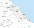
| map | |
 |
|
Arbon is a district in the canton of Thurgau . The main town is Arbon .
The following 12 municipalities belong to the district:
| coat of arms | Name of the parish | Population (December 31, 2018) |
Area in km² |
Inhabitant per km² |
|---|---|---|---|---|
|
|
Amriswil | 13,538 | 19.02 | 712 |
|
|
Arbon | 14,633 | 6.01 | 2435 |
|
|
Dozwil | 694 | 1.30 | 534 |
|
|
Egnach | 4711 | 18.43 | 256 |
|
|
Yeast furnace | 1200 | 6.08 | 197 |
|
|
horn | 2752 | 1.72 | 1600 |
|
|
Kesswil | 992 | 4.46 | 222 |
|
|
Roggwil (TG) | 3068 | 12.03 | 255 |
|
|
Romanshorn | 11'165 | 8.73 | 1279 |
|
|
Salmsach | 1457 | 2.71 | 538 |
|
|
Sommeri | 571 | 4.22 | 135 |
|
|
Uttwil | 1857 | 4.36 | 426 |
| Total (12) | 56,638 | 89.07 | 636 | |
As of December 31, 2017
Changes in the community

Parishes until 1856

Municipalities until 1924

Municipalities until 1935

Municipalities until 1966
Municipalities until 1997

Municipalities until 2010


- 1925: Merger of Hemmerswil and Amriswil → Amriswil
- 1936: Change of the village Niederaach from the municipality Hefenhofen to the municipality Oberaach
- 1967: Merger of Niedersommeri and Obersommeri → Sommeri
- 2011: District change Amriswil from the former district Bischofszell → District Arbon
Web links
Commons : Arbon district - collection of images, videos and audio files
Individual evidence
- ↑ Permanent and non-permanent resident population by year, canton, district, municipality, population type and gender (permanent resident population). In: bfs. admin.ch . Federal Statistical Office (FSO), August 31, 2019, accessed on December 22, 2019 .
- ↑ Federal Statistical Office Generalized Limits 2020.
Districts of the canton of Thurgau
Arbon | Frauenfeld | Kreuzlingen | Münchwilen | Weinfelden
Former districts: Bischofszell | Diessenhofen | Steckborn
Canton of Thurgau | Districts of Switzerland | Municipalities of the Canton of Thurgau