
Roggwil TG
| TG is the abbreviation for the canton of Thurgau in Switzerland and is used to avoid confusion with other entries of the name Roggwil . |
| Roggwil | |
|---|---|
 |
|
| State : |
|
| Canton : |
|
| District : | Arbon |
| BFS no. : | 4431 |
| Postal code : | 9325 (Roggwil TG) 9306 (Freidorf TG) |
| UN / LOCODE : | CH FRE (Freidorf TG) |
| Coordinates : | 747 415 / 262 834 |
| Height : | 440 m above sea level M. |
| Height range : | 399-598 m above sea level M. |
| Area : | 12.03 km² |
| Residents: | 3068 (December 31, 2018) |
| Population density : | 255 inhabitants per km² |
| Website: | www.roggwil-tg.ch |
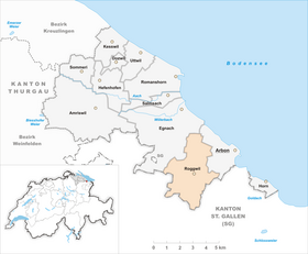
| Location of the municipality | |
  |
|
Roggwil is a municipality and a town in the district of Arbon of the Swiss canton Thurgau . Roggwil is located on the Arbon - St. Gallen road and consists of the clustered villages of Ober- and Unter-Roggwil, the village of Freidorf and numerous hamlets, which grew together in the 20th century .
Until 2002 Roggwil was a unified municipality .
history


According to a bischöflich- fürstäbtischen border treaty from the year 854, in which Rocconwilare is mentioned first documented, came Roggwil 854 to the Bishop of Constance , the jurisdiction of the mid-13th century as a hereditary fief of the of Hagenwil ceded. In 1264 the courts of Hagenwil and Roggwil came to the prince abbey of St. Gallen , which in 1364 enfeoffed the von Breitenlandenberg (1432 opening ) and from 1513 to 1684 that of Bernhausen and took over jurisdiction from 1685 to 1798 itself. Around 1420, the Mötteli von Rappenstein acquired the tower, which they expanded into a castle, which served as a patio from 1517 to 1798 . In 1578 the castle was inherited by the Studer von Winkelbach, in 1650 by the von Bernhausen family, and from 1740 to 1805 it was owned by the monastery.
In the second third of the 19th century, the two primary school communities Roggwil and Freidorf-Watt emerged. In 1860 the hamlets of Ballen and Lengwil were separated from the local and municipal parishes of Roggwil and assigned to the municipality of Egnach . In 1870, the unified municipality of Roggwil was created from the local and municipal parishes formed in 1803 and territorially congruent .
Around 900 Roggwil was part of the parish or parish of Arbon , to which the Roggwil Catholics still belonged at the beginning of the 21st century. In 1746 the reformed parish was detached, including a church building. In 1870 78%, in 1910 71% and in 2000 51% of the community population were Reformed. Until the construction of the St. Otmar Church in Roggwil in 1963, Catholics attended church services in Arbon and Berg .
In addition to the three-part farming, vegetables, flax and fruit were grown, and cattle and dairy farming was increased from the 19th century onwards. In 1900 seven cheese dairies are recorded. There were five mills and two sawmills in the municipality, as well as embroidery around 1900, most of which had ceased operations in 1923. In 1963 Alfred Vogel founded Bioforce AG, a producer of phytotherapeutics. Thanks to its convenient location, there was a brisk residential construction activity in 1980. In 2005 agriculture provided 18% and the second economic factor 46% of the jobs in the municipality.
coat of arms
Blazon : Eight- gest changes from white and red.
The municipality's coat of arms corresponds to the original coat of arms of the Lords of Roggwil .
population
 |
| year | 1850 | 1880 | 1900 | 1950 | 1980 | 1990 | 2000 | 2010 | 2018 |
| Residents | 1284 | 1182 | 1289 | 1542 | 1538 | 1762 | 2462 | 2884 | 3059 |

Of the total of 3,059 inhabitants of the Roggwil municipality in 2018, 331 or 10.8% were foreign nationals. The village of Roggwil had 1545 residents at that time.
economy
In 2016, Roggwil offered work for 1,114 people (converted to full-time positions). 9.3% of these were employed in agriculture and forestry, 49.6% in industry, trade and construction and 41.1% in the service sector.
Attractions


The village of Roggwil and the hamlet of Watt are listed in the inventory of Swiss sites worthy of protection .
The Roggwil Castle , a tripartite system with a high tower, was in the 13th century by the Lords of Roggwil built and is now privately owned.
The Mammertshofen castle was in the 13th century by the Lords of Mammertshofen built Marschalken the monastery of St. Gallen. From 1360 to 1645 it was owned by the Castel taverns . The mighty keep is characteristic of the castle . Today it is privately owned.
traffic
Roggwil is not far from the Arbon-Süd motorway junction of the A1.1 motorway branch . Public transport is the post bus line 200 St. Gallen - Wittenbach - Arbon. In Freidorf there is also the Roggwil-Berg train station on the Romanshorn - St. Gallen line of the Südostbahn .
economy

In Roggwil, in addition to Bioforce, the company kybun AG owned by MBT inventor Karl Müller is based. The company manufactures the kyBoot shoes and kyBounder mats and has built the 30 meter high kybun tower in the center of the village.
Web links
Individual evidence
- ↑ Permanent and non-permanent resident population by year, canton, district, municipality, population type and gender (permanent resident population). In: bfs. admin.ch . Federal Statistical Office (FSO), August 31, 2019, accessed on December 22, 2019 .
- ↑ a b Thurgau in figures 2019 . On the website of the Statistical Office of the Canton of Thurgau (PDF file; 1.8 MB), accessed on April 28, 2020.
- ↑ a b Localities and their resident population. Edition 2019 . On the website of the Statistical Office of the Canton of Thurgau (Excel table; 0.1 MB), accessed on April 28, 2020.
- ↑ a b c municipal coat of arms . On the website of the State Archives of the Canton of Thurgau, accessed on December 8, 2019
-
↑ a b c d Erich Trösch: Roggwil (TG). In: Historical Lexicon of Switzerland .
These sections are largely based on the entry in the Historical Lexicon of Switzerland (HLS), which, according to the HLS's usage information, is under the Creative Commons license - Attribution - Share under the same conditions 4.0 International (CC BY-SA 4.0). - ↑ Verena Rothenbühler: Egnach. In: Historical Lexicon of Switzerland .
- ↑ a b Population development of the municipalities. Canton Thurgau, 1850–2000 and resident population of the municipalities and change from the previous year. Canton of Thurgau, 1990–2018. On the website of the Statistical Office of the Canton of Thurgau (Excel tables; 0.1 MB each), accessed on April 28, 2020.
Amriswil | Arbon | Dozwil | Egnach | Yeast oven | Horn | Kesswil | Roggwil | Romanshorn | Salmsach | Sommeri | Uttwil
Former municipalities: Biessenhofen | Frasnacht | Hemmerswil | Mühlebach | Niederaach | Lower summer | Oberaach | Upper summer | Räuchlisberg | Schocherswil
Canton of Thurgau | Districts of the Canton of Thurgau | Municipalities of the Canton of Thurgau