
Amriswil
| Amriswil | |
|---|---|
 |
|
| State : |
|
| Canton : |
|
| District : | Arbon |
| BFS no. : | 4461 |
| Postal code : | 8580 |
| UN / LOCODE : | CH AWL |
| Coordinates : | 740 106 / 268 248 |
| Height : | 437 m above sea level M. |
| Height range : | 424–551 m above sea level M. |
| Area : | 19.02 km² |
| Residents: | 13,538 (December 31, 2018) |
| Population density : | 712 inhabitants per km² |
| Website: | www.amriswil.ch |
 Amriswil market square |
|
| Location of the municipality | |
  |
|
Amriswil , older Ammerschwiil [ˈɑmːərˌʃʋiːl] in the Swiss German local dialect , is a political municipality and a village in the Arbon district in the canton of Thurgau , Switzerland . The community, which has existed since 1979, comprises the former municipality of Amriswil with its former local communities Amriswil, Biessenhofen , Oberaach and Räuchlisberg and, since 1997, Schocherswil .
geography
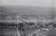
The urbanized industrial village is located in Oberthurgau at the intersection of the Winterthur - Arbon and Konstanz - St. Gallen roads and is accessed by the Winterthur - Romanshorn railway. The community consists of the villages of Amriswil (9769 inhabitants, as of 2000), Oberaach / Biessenhofen (853 inhabitants), Hagenwil / Räuchlisberg (242 inhabitants), Schocherswil (336 inhabitants) and Schrofen (387 inhabitants).
Surname
Amriswil is first mentioned in 799 as Amalgeriswilare . It is a combination of the Old High German male personal name Amalgēr and the Old High German appellative wīlāri "small village, hamlet, farmstead". The place name means "at the Amalger homestead".
history

Presumably, a Roman road already existed in Roman times, which ran from Vitudurum (Oberwinterthur) through what is now Amriswil to Arbor Felix . In the Middle Ages , Amriswil was, together with Brüschwil, an episcopal-Constance fiefdom , while those of Helmsdorf on Eppishausen held jurisdiction from the 15th century . In the early 17th century, Amriswil passed to Adam Tschudi from Glarus, and in 1665 the estate was sold to the St. Gallen Hospital . The court, consisting of Amriswil, Hölzli and Brüschwil as well as houses in Rüti and Giezenhaus, has now been incorporated into the town of Bürglen , whose fate it shared until 1798.

In the middle of the 14th century a Lady Chapel was built, which belonged to the parish of Sommeri . While the majority in Sommeri returned to the old faith after the Reformation (1529), the inhabitants of Amriswil remained true to the Protestant creed, which is why the chapel was awarded to the Reformed. Weekly sermons were held there from 1630, regular Sunday services from 1680, and the Protestant pastor has lived in Amriswil since 1710. Sommeri and Amriswil remained united in a common parish, but immigration in the 19th century changed denominational relationships. In 1891 a large Protestant church was built in Amriswil, in 1911 the Catholics Amriswils separated from Sommeri and an independent parish was founded, and in 1939 the Catholic Church of St. Stephen was inaugurated.
Until around 1830, Amriswil was an inconspicuous farming village with arable and vineyards. The introduction of a livestock market in 1833 and one month market in 1840, the establishment of a dairy in Sommeri in 1852, the advent of calico weaving and the opening of a warp knitting by the German refugee Joseph Sallmannsberg in 1849 marked the beginning of a structural change, according to the opening of the Nordostbahn (1855) intensified. A new settlement area was created between the market square and the train station, and the center shifted from the previous settlement centers around the market square and the intersection in Köpplishaus to the northeast. The rapid industrialization, however, cannot be explained satisfactorily either with the traffic situation or with the modest water power. Rather, initiative entrepreneurs seem to have given important impulses. With the companies Sallmann, Laib and Tuchschmid, Amriswil became a center of the tricot industry, and the clothing and shoe industry also found important representatives with the companies Esco and Löw. The growth led to structural problems, especially with the water supply, which could not be finally solved until 1952 when water was drawn from Lake Constance . With immigration, especially from Italy, the proportion of foreign residents rose from 7% to 29% between 1870 and 1910.
New jobs were created in the construction and service sectors - trading companies, hotels and restaurants, banks, workshops for the disabled (1909), the cantonal kindergarten teachers' seminar (1975). However, the economic dependence on the jersey continued to exist until around 1980, when various companies had to stop their production. In the meantime the economic structure is more balanced: in 1990 there were 90 full-time farms in addition to around 3300 jobs in the second and third economic sectors , 47% of which were in the service sector . In the 20th century, the successes of local gymnastics and sports clubs, e. B. von Volley Amriswil , as well as the cultural activities of the «Akademie Amriswil» founded by the writer Dino Larese in 1937.
In the 20th century, several parish mergers took place in which Amriswil was involved. The local community of Amriswil was joined by the unified community of Hemmerswil in 1925 and by the local community of Mühlebach bei Amriswil in 1932 . In 1979 the local communities of Amriswil, Biessenhofen , Oberaach and Räuchlisberg merged to form the unitary community of Amriswil. In 1997, the local community of Schocherswil, separated from the former municipality of Zihlschlacht , merged with the unitary community of Amriswil. Statistically, Amriswil has been a city since January 1, 2005 .
→ see also the history sections in the articles Almensberg , Biessenhofen , Hagenwil bei Amriswil , Hemmerswil , Mühlebach bei Amriswil , Niederaach , Oberaach , Räuchlisberg and Schocherswil
coat of arms
Blazon : In white a green tree with red apples.
The origin and meaning of the coat of arms that existed before 1945 are unclear. In 1979 the coat of arms was taken over by the newly formed community of Amriswil.
population
 |
| year | 1831 | 1850 | 1880 | 1910 | 1941 | 1970 |
| Residents | 233 | 492 | 1533 | 3322 | 5377 | 7601 |
| year | 1970 | 1980 | 1990 | 2000 | 2010 | 2018 |
| Residents | 9190 | 9013 | 10,426 | 11,357 | 12,134 | 13'460 |
Of the total of 13,460 inhabitants in the municipality of Amriswil in 2018, 4,284 or 31.8% were foreign nationals. 4118 (30.6%) were Roman Catholic and 3598 (26.7%) were Protestant Reformed. The village of Amriswil had 11,892 inhabitants at that time.
politics
In the 2019 National Council elections, the share of the vote in Amriswil was: SVP 37.7%, FDP 12.6%, SP 12.0%, CVP 11.9%, Greens 10.5%, glp 6.4%, EDU 4.2 %, BDP 4.0%, EVP 2.4%.
economy
In 2016, Amriswil offered work for 4,661 people (converted to full-time positions). 3.4% of these were employed in agriculture and forestry, 35.5% in industry, trade and construction and 61.2% in the service sector.
Attractions


In the middle of Amriswil is the large reformed church in neo-Gothic style, whose 75 m high steeple is the highest in the canton of Thurgau. The Catholic Church of St. Stephen from 1939 is one of the first modern church buildings in the canton of Thurgau.
The parish hall with the village square forms a unit. The “Festhütte”, a large festival hall from 1907, was demolished in 2006 and replaced by the new pentagonal “Pentorama” building, which was completed in autumn 2007 and which, thanks to its striking architecture, has become the city's new landmark; in spring 2009 he was featured on a Swiss Post stamp.
In the village of Hagenwil is the moated castle Hagenwil , which houses a restaurant and art exhibitions. Hagenwil is listed in the inventory of places worth protecting in Switzerland .
In 1989, the Amriswil City Museum was opened in part of the Sallmann textile factory . In over 4000 exhibits and numerous brochures, it shows the history of the 1200 year old town. The museum is where Joseph Sallmann founded Switzerland's first tricot factory in 1850.
The timber frame house in Schrofen dates back to 1538. The typical design in central and eastern Thurgau until the end of the 16th century is only preserved in a few post structures and only here is open to the public as a residential museum.
In 2002 the national school museum in Amriswil was opened.
About two kilometers south of Amriswil, a lookout tower was built in 2012, which is called "Gewerbeturm" because of the funding from the then hundred-year-old Amriswil trade association (and numerous sponsors).
Town twinning
Amriswil has been twinned with the German city of Radolfzell on Lake Constance since 1999 . This sealed a long-term bond between the two communities: after the Second World War , Radolfzell children were able to visit Amriswil families, and food, medicines and other relief items were sent from Amriswil to Radolfzell.
traffic

Amriswil is a traffic junction for regional road traffic, where the main road 14 from Romanshorn to Frauenfeld intersects with the Kreuzlingen - St. Gallen roads and the roads to Arbon and Bischofszell .
The “Weltdorf” is the stopping point for the Intercity trains on the Romanshorn-Zurich route . The Autokurse Oberthurgau operate bus routes to Arbon, Romanshorn, Bischofszell and Muolen on the Romanshorn - St. Gallen railway line .
Personalities
- Hans Brühlmann (1878–1911), painter
- Dino Larese (1914-2001), poet
- Gottfried Weilenmann (1920–2018), cyclist
- Peter Kummer (1945–2017), politician, mayor and honorary citizen
- Marco Krattiger (* 1994), volleyball and beach volleyball player
Trivia
According to Martin Salvisberg, then Mayor of Amriswil and today's Mayor (SVP) of Amriswil, it was possible to find out in issue 1 of the 2011 year of the statistical reports of the canton of Thurgau that the proportion of Macedonians in the city is above average (25% of foreigners - compared to one Cantonal value of 1.9 percent).
photos

City administration Amriswil

Catholic Church

Pentorama Amriswil
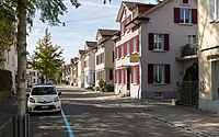
Free street in Amriswil

ISA Bodywear in Amriswil


literature
- Stefan Länzlinger, Martin Lengwiler and Thomas Meyer: Amriswil. History from the middle of the 19th to the end of the 20th century. Municipality, Amriswil 1999, ISBN 3-9521685-0-5 .
Web links
Individual evidence
- ↑ Permanent and non-permanent resident population by year, canton, district, municipality, population type and gender (permanent resident population). In: bfs. admin.ch . Federal Statistical Office (FSO), August 31, 2019, accessed on December 22, 2019 .
- ↑ a b Thurgau in figures 2019 . On the website of the Statistical Office of the Canton of Thurgau (PDF file; 1.8 MB), accessed on April 28, 2020.
- ↑ Swiss land use statistics. Completed on July 1, 1912. Published by the Federal Statistical Bureau. ( Memento from April 12, 2016 in the Internet Archive )
- ↑ a b Lexicon of Swiss municipality names . Edited by the Center de Dialectologie at the University of Neuchâtel under the direction of Andres Kristol. Frauenfeld / Lausanne 2005, p. 88 f.
- ↑ a b Localities and their resident population. Edition 2019 . On the website of the Statistical Office of the Canton of Thurgau (Excel table; 0.1 MB), accessed on April 28, 2020.
- ↑ StiASG , Urk. I 146. Online at e-chartae , accessed on June 12, 2020.
- ↑ Alois Degenhardt: The Amriswiler shoe industry - a review. Thurgauer Jahrbuch 1997, accessed on April 12, 2020 .
-
^ A b Gregor Spuhler : Amriswil. In: Historical Lexicon of Switzerland .
These sections are largely based on the entry in the Historical Lexicon of Switzerland (HLS), which, according to the HLS's usage information, is under the Creative Commons license - Attribution - Share under the same conditions 4.0 International (CC BY-SA 4.0). - ↑ a b c population development of the municipalities. Canton Thurgau, 1850–2000 and resident population of the municipalities and change from the previous year. Canton of Thurgau, 1990–2018. On the website of the Statistical Office of the Canton of Thurgau (Excel tables; 0.1 MB each), accessed on April 28, 2020.
- ↑ a b municipal coat of arms . On the website of the State Archives of the Canton of Thurgau, accessed on December 8, 2019
- ^ Federal Statistical Office : NR - Results parties (municipalities) (INT1). In: Federal Elections 2019 | opendata.swiss. August 8, 2019, accessed August 1, 2020 .
- ↑ Amriswil website
- ↑ Larese asks: “Where is Amriswil?”. In: St. Galler Tagblatt (online) of September 30, 2011
- ↑ Welcome to the AOT. On the website of Autokurse Oberthurgau (AOT), accessed on November 1, 2019
- ↑ Issue 1/2011 of the statistical reports of the Canton of Thurgau
Remarks
- ↑ including Hemmerswil and Mühlebach
Amriswil | Arbon | Dozwil | Egnach | Yeast oven | Horn | Kesswil | Roggwil | Romanshorn | Salmsach | Sommeri | Uttwil
Former municipalities: Biessenhofen | Frasnacht | Hemmerswil | Mühlebach | Niederaach | Lower summer | Oberaach | Upper summer | Räuchlisberg | Schocherswil
Canton of Thurgau | Districts of the Canton of Thurgau | Municipalities of the Canton of Thurgau