
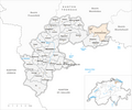
Münchwilen district
| Münchwilen district | |
|---|---|
 |
|
| Basic data | |
| Country: |
|
| Canton : |
|
| Main town : | Münchwilen TG |
| FSO number : | 2014 |
| Area : | 138.19 km² |
| Height range : | 422–991 m above sea level M. |
| Residents: | 47,325 (December 31, 2018) |
| Population density : | 342 inhabitants per km² |
| map | |
 |
|
Münchwilen is a district in the canton of Thurgau . The main town is Münchwilen . The traditional name of the landscape is Hinterthurgau , and the region is popularly called Tannzapfenland. As an economic region, it was marketed as Südthurgau from 2009 to 2016 .
From 1798 to 1871 Täger was the district capital.
Political communities
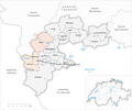
The following 13 municipalities belong to the district:
As of January 1, 2011
| coat of arms | Name of the parish | Population (December 31, 2018) |
Area in km² |
Inhabitant per km² |
|---|---|---|---|---|
|
|
Aadorf | 9037 | 19.94 | 453 |
|
|
Bed meadows | 1247 | 3.85 | 324 |
|
|
Bichelsee-Balterswil | 2864 | 12.26 | 234 |
|
|
Braunau | 778 | 9.17 | 85 |
|
|
Eschlikon | 4372 | 6.22 | 703 |
|
|
Fischingen | 2792 | 30.58 | 91 |
|
|
Lommis | 1215 | 8.61 | 141 |
|
|
Münchwilen (TG) | 5624 | 7.81 | 720 |
|
|
Rickenbach (TG) | 2774 | 1.58 | 1756 |
|
|
Sirnach | 7766 | 12.38 | 627 |
|
|
Tobel-Tägerschen | 1615 | 7.11 | 227 |
|
|
Wängi | 4720 | 16.43 | 287 |
|
|
Wilen (TG) | 2521 | 2.25 | 1120 |
| Total (13) | 47,325 | 138.19 | 342 | |
Changes in the community

Municipalities until 1870

Municipalities until 1949

Municipalities until 1952
Municipalities until 1963

Parishes until 1968

Municipalities until 1970

Municipalities until 1971

Municipalities until 1994
Municipalities until 1995

Municipalities until 1996

Municipalities until 1998

Municipalities until 2010


- 1871: Merger of Holzmannshaus and Oberhofen near Münchwilen → Oberhofen near Münchwilen
- 1950: Merger of Münchwilen , Oberhofen bei Münchwilen and St. Margarethen → Münchwilen
- 1953: Change of name from Buch bei Affeltrangen → Buch bei Märwil
- 1964: Fusion Schönholzerswilen and Toos → Schönholzerswilen
- 1971: Merger of Heiligkreuz , Hosenruck and Wuppenau → Wuppenau
- 1972: Merger of Au , Dussnang , Fischingen , Oberwangen and Tannegg → Fischingen
- 1995: Fusion Affeltrangen , Buch bei Märwil , Märwil and Zezikon → Affeltrangen
- 1995: Fusion of Kalthäusern , Lommis and Weingarten → Lommis
- 1995: Merger of Lustdorf , Thundorf and Wetzikon → Thundorf
- 1996: Fusion of Balterswil and Bichelsee → Bichelsee-Balterswil
- 1996: Merger of the districts of Heiterschen and Jakobstal from Wittenwil and Wängi → Wängi
- 1997: Fusion Busswil Horben , Sirnach and Wiezikon → Sirnach
- 1997: Eschlikon and Wallenwil → Eschlikon merge
- 1999: Merger of Tägerschen and Tobel → Tobel-Tägerschen
- 2011: Aadorf district change from Frauenfeld district to Münchwilen district
- 2011: Change of district Affeltrangen , Schönholzerswilen and Wuppenau from Münchwilen district → Weinfelden district
Web links
Individual evidence
- ↑ Permanent and non-permanent resident population by year, canton, district, municipality, population type and gender (permanent resident population). In: bfs. admin.ch . Federal Statistical Office (FSO), August 31, 2019, accessed on December 22, 2019 .
- ↑ Why the southernmost part of the canton is called Hinterthurgau. In: Regionaljournal Ostschweiz from 9 September 2016
- ^ History. On the website of the Tobel-Tägerschen community, accessed on November 30, 2019
- ↑ Federal Statistical Office Generalized Limits 2020.
Arbon | Frauenfeld | Kreuzlingen | Münchwilen | Weinfelden
Former districts: Bischofszell | Diessenhofen | Steckborn
Canton of Thurgau | Districts of Switzerland | Municipalities of the Canton of Thurgau