
Tuttwil
| Tuttwil | ||
|---|---|---|
 |
||
| State : |
|
|
| Canton : |
|
|
| District : | Münchwilen | |
| Political community : | Wängi | |
| Postal code : | 9546 | |
| former BFS no. : | 4783 | |
| Coordinates : | 713 122 / 260330 | |
| Height : | 612 m above sea level M. | |
| Area : | 3.64 km² | |
| Residents: | 541 (December 31, 2018) | |
| Population density : | 149 inhabitants per km² | |
 Tuttwil |
||
| map | ||
|
||

Tuttwil is a village in the political municipality of Wängi in the Münchwilen district of the canton of Thurgau in Switzerland .
From 1816 to 1968 Tuttwil was a local parish of the municipal community of Wängi. 1969 Tuttwil came to the united community Wängi.
geography
Tuttwil is located south of Wängi on the Tuttwilerberg and consists of Ober- and Untertuttwil with the hamlets of Breitenloh, Scheuer and Wilhof.
history

Traces of Roman settlements in Obertuttwil indicate that the area was already inhabited in antiquity .
Tuttwil was first mentioned in 1244 as Tuotwille . In the Middle Ages , the Kreuzlingen monastery (1244) and the Johanniterkomturei Tobel owned goods in Tuttwil. In 1282, the Konstanz Cathedral Monastery gave the Kehlhof to Fischingen Monastery . Tuttwil was under Habsburg-Austrian rule until 1460, and from 1460 to 1798 Tuttwil was part of the Tuttwilerberg High Court . Ecclesiastically, Tuttwil always shared the fate of the parish of Wängi.
Up until the 19th century, mainly arable and fruit growing was practiced, then there was a shift from grain to cattle and dairy farming. The Stieger'sche cheese dairy was established in 1862. From 1785 Obertuttwil was a changing station on the old Zurich - St. Gallen road , which led over the Tuttwilerberg until the middle of the 19th century. The prestressing services and the inns brought additional earnings. In the 19th century next to the spinning, weaving and was Ferggerei of cotton some embroidery operated. From 1960 new residential buildings were built on the outskirts of the village.
In 1969 the four local communities of Tuttwil, Anetswil , Krillberg and Wängi merged to form the unitary community of Wängi, which still exists today as a political community.
population

| year | 1850 | 1900 | 1950 | 1960 | 2018 |
| Residents | 411 | 329 | 309 | 309 | 541 |
Of the total of 541 inhabitants in the town of Tuttwil in 2018, 37 or 6.8% were foreign nationals. 245 (45.3%) were Protestant Reformed and 171 (31.6%) were Roman Catholic.
Attractions
The following buildings are included in the list of cultural assets in Wängi :

Chapel of St. Stephan and ...

... former “Altes Rössli” tavern in Tuttwil

David's house (left), Hoepli house (right part of the house) ...
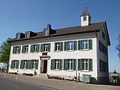
... and the school in Untertuttwil


Personalities
- Johann Adam Pupikofer (1797–1882), historian and reformed clergyman
- Ulrico Hoepli (1847–1935), bookseller and publisher
- Erwin Kessler (* 1944), animal rights activist and civil engineer.
Web links
Individual evidence
- ↑ Swiss land use statistics. Completed on July 1, 1912. Published by the Federal Statistical Bureau. ( Memento from April 12, 2016 in the Internet Archive )
- ↑ a b c d Localities and their resident population. Edition 2019 . On the website of the Statistical Office of the Canton of Thurgau (Excel table; 0.1 MB), accessed on April 28, 2020.
-
↑ a b c d
Erich Trösch: Tuttwil. In: Historical Lexicon of Switzerland .
These sections are largely based on the entry in the Historical Lexicon of Switzerland (HLS), which, according to the HLS's usage information, is under the Creative Commons license - Attribution - Share under the same conditions 4.0 International (CC BY-SA 4.0).
Aadorf | Bed meadows | Bichelsee-Balterswil | Braunau | Eschlikon | Fischingen | Lommis | Münchwilen | Rickenbach | Sirnach | Tobel-Tägerschen | Wängi | Wilen
Former communities: Aawangen | Anetswil | Au | Balterswil | Bichelsee | Busswil | Dussnang | Ettenhausen | Guntershausen | Hofen | Holzmannshaus | Horben | Cold houses | Krillberg | Littenheid | Oberhofen near Münchwilen | Oberwangen | St. Margarethen | Tagerschen | Tannegg | Tobel | Tuttwil | Wallenwil | Vineyard | Wiezikon | Wittenwil
Canton of Thurgau | Districts of the Canton of Thurgau | Municipalities of the Canton of Thurgau