Ettenhausen TG
| TG is the abbreviation for the canton of Thurgau in Switzerland and is used to avoid confusion with other entries of the name Ettenhausen . |
| Ettenhausen | ||
|---|---|---|
| State : |
|
|
| Canton : |
|
|
| District : | Frauenfeld | |
| Political community : | Aadorf | |
| Postal code : | 8356 | |
| former BFS no. : | 4553 | |
| Coordinates : | 710040 / 259420 | |
| Height : | 534 m above sea level M. | |
| Area : | 3.28 km² | |
| Residents: | 1348 (December 31, 2018) | |
| Population density : | 411 inhabitants per km² | |
| Website: | www.ettenhausen.ch | |
|
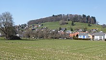
Village center |
||
| map | ||
|
|
||
Ettenhausen is a former municipality and a village in the political municipality of Aadorf in the Frauenfeld district of the canton of Thurgau , Switzerland .
The local community Ettenhausen belonged from 1803 to 1995 to the municipal community of Aadorf. 1996 united to Ettenhausen with the local churches Aadorf, Aawangen , Guntershausen bei Aadorf and Wittenwil the political community Aadorf.
geography
Ettenhausen borders to the north, east and south on the former Thurgau local communities Aadorf, Guntershausen and Bichelsee , to the west on the Zurich communities Elgg and Hofstetten (ZH) . The area of the former local parish of Ettenhausen covers 3.34 km². The place is at 543 m above sea level. M. The highest point is 810 m above sea level. M. Haselberg, the lowest point marks the Tänikonerstrasse at 543 m above sea level. M.
climate
The average amount of precipitation measured at the Tänikon weather station is 1180 mm per year. Rain falls on 158 days a year, 81 of which are summer and 77 are winter days. The average annual temperature is 8.2 degrees Celsius. The coldest month of the year is January with an average temperature of −0.6 degrees Celsius, the warmest month of July with an average of 16.9 degrees Celsius.
history
Ettenhausen was first mentioned in a document as Oetenhusen in 1278. Ettenhausen was originally an imperial estate ( Mark Tänikon) and belonged to the lords of Bichelsee in the 13th century as a St. Gallen fiefdom . From the 13th to the 15th century, the nearby Tänikon monastery gradually acquired goods and rights of rule. In 1424 its jurisdiction was confirmed. The lower court of Ettenhausen, which was independent after its opening in 1578 , remained part of the Tänikon rule until 1798 .
Before the Reformation , Ettenhausen belonged to the parish of Elgg , after the restoration of Tänikon in 1548–1550 and the re-Catholicization of the monastic fiefs from 1566 to the new Catholic parish of Tänikon. In 1848 the parish became independent from the monastery. According to Aadorf, the Reformed are ecclesiastical.
Over the centuries, grain cultivation in the three-part system and viticulture was practiced in Ettenhausen . The transition to cattle and dairy farming took place in the 19th century. Between 1951 and 1959, goods were amalgamated. Today, the non-industrialized Ettenhausen is a preferred place of residence with a very high proportion of commuters. a. to Zurich , Winterthur and Aadorf. After 1950, single-family houses were built to the west (Rebberg) and north (Kilchberg, Weidli) of the village center.
Timetable
- 1253: Iltishausen was first mentioned in a document as Hiltishusen
- 1278: Ettenhausen was first mentioned in a document as Oetenhusen
- 1320: Ettenhausen comes to the Tänikon monastery
- 1347: First written mention of the Ettenhauser wine
- 1512: Village law between Ettenhausen and the Tänikon monastery
- 1803–1871: The "Gmeind Ettenhausen" gradually emerged as the civil parish as a corporation of those involved in the civil estate and the local parish as the resident community
- 1827: Foundation of the primary school community in Ettenhausen
- 1840: Construction of the "Schmiede" farm
- 1871: Distribution of property between the civil parish and the local parish
- 1873: Construction of the «Hirschen» inn
- 1874: Foundation of the field riflemen as the oldest local club
- 1880: Establishment of the Ettenhausen-Guntershausen Agricultural Cooperative
- 1887: Opening of the post office
- 1896: Introduction of the telephone in the form of a community intercom
- 1900: Creation of the high-pressure water supply and the reservoir
- 1912: Introduction of electricity on a cooperative basis (Elektra Ettenhausen)
- 1916: The last vines in the lower western vineyard are uprooted
- 1922: Fire in each of five houses and barns in Zehntenstrasse
- 1947: The timber construction company Paul Baumgartner AG was founded, which is still the largest employer today
- 1951–1959: Amalgamation of goods (fields, forests and drainage)
- 1959: First local planning with building regulations and zoning plan; Total revision 1980
- 1969: Inauguration of the Weidli school complex
- 1975: The male choir replanted a piece of the former vineyard
- 1979: Establishment of the Kilberg antenna cooperative
- 1983: The new post office goes into operation
- 1991: Death of the Russian writer Alja Rachmanowa (* 1898)
- 1991–1994: Community reorganization with four votes, two of which were random results
- 1992: Ettenhausen has 1000 inhabitants
- 1996: The local communities of Aadorf , Aawangen, Ettenhausen, Guntershausen and Wittenwil merged to form the political community of Aadorf
coat of arms
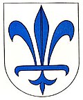
The lily and the colors of the Ettenhausen municipal coat of arms go back to the Tänikon monastery, which had a white lily on a blue ground.
population
| year | 1850 | 1950 | 1990 | 2000 | 2010 | 2018 |
|---|---|---|---|---|---|---|
| Local parish | 321 | 395 | 941 | |||
| Locality | 1005 | 959 | 1348 | |||
| source | ||||||
Of the total of 1348 inhabitants in Ettenhausen in 2018, 100 or 7.4% were foreign nationals. 502 (37.2%) were Roman Catholic and 467 (34.6%) were Protestant Reformed.
Attractions
literature
- Louis Hürlimann: Ettenhausen. A walk through its history. 1999
Web links
- www.ettenhausen.ch Official website
Individual evidence
- ↑ Swiss land use statistics. Completed on July 1, 1912. Published by the Federal Statistical Bureau. ( Memento from April 12, 2016 in the Internet Archive )
- ↑ a b c Localities and their resident population. Edition 2019 . On the website of the Statistical Office of the Canton of Thurgau (Excel table; 0.1 MB), accessed on April 28, 2020.
-
↑ a b c d e
André Salathé: Ettenhausen (TG). In: Historical Lexicon of Switzerland .
These sections are largely based on the entry in the Historical Lexicon of Switzerland (HLS), which, according to the HLS's usage information, is under the Creative Commons license - Attribution - Share under the same conditions 4.0 International (CC BY-SA 4.0). - ↑ Population development of the municipalities. Canton of Thurgau, 1850-2000. On the website of the Statistical Office of the Canton of Thurgau (Excel table; 0.1 MB), accessed on April 28, 2020.
- ^ History. On the website of the residents' association Ettenhausen, accessed on January 4, 2020
- ↑ Locations and Settlements Directory. Canton of Thurgau, 2005 edition . On the website of the Statistical Office of the Canton of Thurgau (PDF; 1.7 MB), accessed on April 28, 2020.
- ↑ Locations and Settlements Directory. Canton of Thurgau, 2012 edition. On the website of the Statistical Office of the Canton of Thurgau (PDF; 3.4 MB), accessed on May 11, 2020.
Remarks
- ↑ with outside courtyards


