
Dussnang
| Dussnang | ||
|---|---|---|
 |
||
| State : |
|
|
| Canton : |
|
|
| District : | Münchwilen | |
| Political community : | Fischingen | |
| Postal code : | 8374 | |
| former BFS no. : | 4727 | |
| Coordinates : | 714 999 / 254528 | |
| Height : | 593 m above sea level M. | |
| Area : | 4.76 km² | |
| Residents: | 547 (1970) | |
| Population density : | 115 inhabitants per km² | |
 Dussnang |
||
| map | ||
|
||

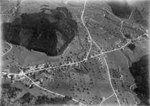
Dussnang is a village and a former municipality in the political municipality Fischingen in the Münchwilen district of the canton of Thurgau in Switzerland .
In 1972 Dussnang merged with the local communities Au , Dussnang, Fischingen, Oberwangen and Tannegg and the municipal community Fischingen to form the unified community Fischingen.
coat of arms
Blazon : a red eight-spoke wheel in white .
geography
The village is located in the upper Murg Valley , at the heavily forested northern foot of the Hörnli, which is rich in precipitation . Together with Oberwangen and Vogelsang, Dussnang forms the center of the political community of Fischingen.
history


Dussnang is mentioned for the first time as Tuzzinwang 754 in the Henauer deed of Rothpaldus to the monastery of St. Gallen. From 996 to 999 goods, church and tithes were transferred to the episcopal- Constantine monastery Petershausen near Constance .
In the 13th century , the lords of Dussnang were the Toggenburg ministries in the service of the Prince Abbey of St. Gallen . Tannegg Castle was built around 1240 by Bishop Heinrich von Tanne from Constance (in office from 1233 to 1248) . The castle and a small town complex were built as the center of power for the Bishop of Constance in Hinterthurgau. The town was destroyed in 1407 by the Appenzeller. The main tower of the fortress stood until 1837. Then it was dismantled and the stones used to build bridges.
The lower jurisdiction over the village belonged to the diocese of Constance , which was owned by the Tannegg office named after the Tannegg Castle . All of this was sold to Fischingen Abbey in 1693. The jurisdiction of the Tanneggeramt existed until 1798. In the 18th century, Dussnang was still called Tusslingen .
In 1244 Fischingen Monastery incorporated the Dussnang parish, which has probably existed since the early Middle Ages. The 11/12 The church, built in the 16th century, was expanded in 1523 and consecrated to the Holy Cross . In 1529 a reformed parish was established, to which Bichelsee also belonged from 1544/50 . From 1542 until the elevation of St. Mary's Church, built on a private initiative in 1890, to a Catholic parish church in 1900, parity was applied .
Agriculture dominated the northern slope of the Hörnli, which is rich in precipitation, until the 20th century, with home weaving and embroidery securing its livelihood in the 19th century. Early peasant self-help measures led to the establishment of an agricultural cooperative in 1886 and a cattle breeding cooperative in 1895. In the 19th century there were only 14 houses in Dussnang. Only with the establishment of the Kneipp Kurhaus in 1890 did a major development take place.
Population and economy
| year | 1850 | 1900 | 1970 | 2010 | 2018 |
|---|---|---|---|---|---|
| Local parish | 342 | 504 | 547 | ||
| Locality | 673 | 1273 | |||
| source | |||||
Up until the 20th century it was mainly agriculture that ensured the livelihood of the population. Home weaving and embroidery were added in the 19th century. In 1886 an agricultural cooperative and in 1895 a cattle breeding cooperative was founded. The Kneipp spa, which opened in 1891, was extensively modernized from 1974 to 1982.
Of the total of 1273 inhabitants in Dussnang in 2018, 97 or 7.6% were foreign nationals. 552 (43.4%) were Roman Catholic and 410 (32.2%) Protestant Reformed.
Attractions

The Tannegg castle ruins are located at 725 m above sea level. M. on the eastern Tanneggergrat. The remains of the castle (see above) were archaeologically researched and restored in 1997.
The 11/12 The Kreuzkirche, built in the 16th century, was expanded in 1523 and consecrated to the Holy Cross . The originally Catholic church was used equally from 1542. Since the construction of the Catholic Marienkirche in 1890, it has only been used by the Protestant parish.
photos

Reformed Kreuzkirche
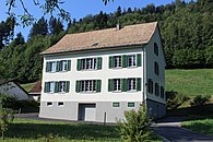
Listed reformed rectory

View from the park to the Kurhaus
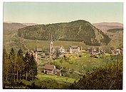
Dussnang on a postcard from around 1900


Web links
Individual evidence
- ↑ Swiss land use statistics. Completed on July 1, 1912. Published by the Federal Statistical Bureau. ( Memento from April 12, 2016 in the Internet Archive )
-
↑ a b c d e f Gregor Spuhler : Dussnang. In: Historical Lexicon of Switzerland .
These sections are largely based on the entry in the Historical Lexicon of Switzerland (HLS), which, according to the HLS's usage information, is under the Creative Commons license - Attribution - Distribution under the same conditions 4.0 International (CC BY-SA 4.0). - ↑ StiASG , Urk. Bremen 7. Online at e-chartae , accessed on June 25, 2020.
- ↑ Locations and Settlements Directory. Canton of Thurgau, 2012 edition. On the website of the Statistical Office of the Canton of Thurgau (PDF; 3.4 MB), accessed on May 11, 2020.
- ↑ a b Localities and their resident population. Edition 2019 . On the website of the Statistical Office of the Canton of Thurgau (Excel table; 0.1 MB), accessed on April 28, 2020.
Remarks
- ↑ The settlements of the local community Tannegg today belong to the village of Dussnang
- ↑ without outside courtyards
Aadorf | Bed meadows | Bichelsee-Balterswil | Braunau | Eschlikon | Fischingen | Lommis | Münchwilen | Rickenbach | Sirnach | Tobel-Tägerschen | Wängi | Wilen
Former communities: Aawangen | Anetswil | Au | Balterswil | Bichelsee | Busswil | Dussnang | Ettenhausen | Guntershausen | Hofen | Holzmannshaus | Horben | Cold houses | Krillberg | Littenheid | Oberhofen near Münchwilen | Oberwangen | St. Margarethen | Tagerschen | Tannegg | Tobel | Tuttwil | Wallenwil | Vineyard | Wiezikon | Wittenwil
Canton of Thurgau | Districts of the Canton of Thurgau | Municipalities of the Canton of Thurgau