Tagerschen
| Tagerschen | ||
|---|---|---|
| State : |
|
|
| Canton : |
|
|
| District : | Münchwilen | |
| Political community : | Tobel-Tägerschen | |
| Postal code : | 9555 | |
| former BFS no. : | 4772 | |
| Coordinates : | 719 917 / 263166 | |
| Height : | 545 m above sea level M. | |
| Area : | 4.18 km² | |
| Residents: | 637 (December 31, 2018) | |
| Population density : | 152 inhabitants per km² | |
| map | ||
|
|
||
Tägerschen was a local municipality in the municipality of Tobel and is a village in the municipality of Tobel-Tägerschen in the Münchwilen district of the canton of Thurgau in Switzerland . From 1798 to 1871 Tägerschen was the capital of today's Münchwilen district . On January 1, 1999 , Tägerschen merged with the local community of Tobel to form the community of Tobel-Tägerschen.
geography
Tägerschen is at the junction of the country roads from Märstetten to Wil SG or Münchwilen. In addition to the farming village, the local community included the hamlets of Karlishub and Thürn.
Tägerschen has a train station on the Weinfelden – Wil SG line .
history
The settlement was first mentioned in 762 as Tegarascha . Goods came to the St. Gallen monastery in the 8th and 9th centuries . Jurisdiction came through the Toggenburgers and their servants from Heitnau in 1258 to the Johanniterkomturei Tobel , which gradually expanded their land and judicial rule until around 1500 . The only exception to this was the so-called outdoor seating area, which was given freedom from the lock in 1547 and whose owners changed frequently. From 1798 to 1871 it served as the official seat of the district governor of Tobel. Later it housed an embroidery factory, then the cheese factory until the beginning of the 21st century. A village law first recorded in writing in 1490 regulated everyday life. Catholics and Protestants are incorporated into the parishes of Tobel and Affeltrangen .
The population lived from grain growing in three tents and viticulture. In the 19th century the transition to field grass took place, from 1911 fruit growing with deliveries to the Märwil cider factory was increased . From 1870 to 1914 Tägerschen experienced the embroidery boom, which in 1910 provided work for 26 employees. A needle factory has been located there since 1924 and a tank farm for petroleum products with a rail connection to the Mittelthurgau Railway since 1978 .
coat of arms
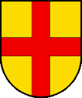
Blazon : In yellow with a red cross .
The cross refers to the Tobel Commandery, the colors to the coat of arms of the Lords of Heitnau.
population
Of the total of 637 inhabitants in the village of Tägerschen in 2018, 96 or 15.1% were foreign nationals. 298 (46.8%) were Roman Catholic and 181 (28.4%) Protestant Reformed.
| year | 1850 | 1880 | 1900 | 1950 | 1990 | 2000 | 2010 | 2018 |
|---|---|---|---|---|---|---|---|---|
| Local parish | 226 | 188 | 214 | 272 | 389 | |||
| Locality | 382 | 452 | 637 | |||||
| source | ||||||||
Attractions
The following buildings from Tägerschen are included in the list of cultural assets :
Personalities
- Fridolin Suter (1863–1937), born in Tobel, honorary canon in Solothurn and honorary citizen of Bischofszell
Web links
Individual evidence
- ↑ Swiss land use statistics. Completed on July 1, 1912. Published by the Federal Statistical Bureau. ( Memento from April 12, 2016 in the Internet Archive )
- ↑ a b c d Localities and their resident population. Edition 2019 . On the website of the Statistical Office of the Canton of Thurgau (Excel table; 0.1 MB), accessed on April 28, 2020.
- ^ History. On the website of the Tobel-Tägerschen community, accessed on November 30, 2019
-
↑ a b c d
André Salathé: Tägerschen. In: Historical Lexicon of Switzerland .
These sections are largely based on the entry in the Historical Lexicon of Switzerland (HLS), which, according to the HLS's usage information, is under the Creative Commons license - Attribution - Share under the same conditions 4.0 International (CC BY-SA 4.0). - ↑ a b municipal coat of arms . On the website of the State Archives of the Canton of Thurgau, accessed on December 8, 2019.
- ↑ Locations and Settlements Directory. Canton of Thurgau, 2005 edition . On the website of the Statistical Office of the Canton of Thurgau (PDF; 1.7 MB), accessed on April 28, 2020.
- ↑ Locations and Settlements Directory. Canton of Thurgau, 2012 edition. On the website of the Statistical Office of the Canton of Thurgau (PDF; 3.4 MB), accessed on May 11, 2020.
Remarks
- ↑ with outside courtyards


