
Affeltrangen
| Affeltrangen | |
|---|---|
 |
|
| State : |
|
| Canton : |
|
| District : | Weinfelden |
| BFS no. : | 4711 |
| Postal code : | 9556 Affeltrangen 9562 Märwil |
| UN / LOCODE : | CH MAE (Märwil) |
| Coordinates : | 718 857 / 264075 |
| Height : | 489 m above sea level M. |
| Height range : | 469–629 m above sea level M. |
| Area : | 14.43 km² |
| Residents: | 2552 (December 31, 2018) |
| Population density : | 177 inhabitants per km² |
| Website: | www.affeltrangen.ch |
 Affeltrangen |
|
| Location of the municipality | |
  |
|
Affeltrangen (in local dialect : Afeltrange [ (fo) ˈafl̩traŋˑə ]) is a town and a municipality in the district of Weinfelden in the canton of Thurgau in Switzerland . The political municipality, which has existed since 1995, coincides spatially with the municipal municipality Affeltrangen, which was abolished at the end of 1994 and which included the former local communities Affeltrangen, Buch bei Märwil , Märwil and Zezikon . In addition to the four villages, some hamlets (such as Kaltenbrunnen) and individual farms belong to the municipality.
geography
The community is located in the upper Lauchetal at the confluence of the Hartenauerbach . The former local community Affeltrangen enclosed the church village Affeltrangen with Bollsteg, Isenegg, Kreuzegg, Nägelishub and Rüti.
history

Affeltrangen was first mentioned in 779: A certain property donated land in villa que dicitur Affaltrawangas to the St. Gallen monastery . The place name is composed of ahd. Apholtra / affaltra ‹Apfelbaum› and wang ‹Feld, Au, Wiese, Hang›. With a further donation by Count Isenbart in 798, the monastery also acquired jurisdiction over Affeltrangen. From 1228, the property was gradually transferred to the Tobel Commandery , directly and via the Toggenburgers and their servants , to whose jurisdiction Affeltrangen belonged entirely from approx. 1280 to 1798. An opening in 1467 regulated village life.
Lommis , Märwil and Tobel broke away from the mother parish of the Church of St. Johann Baptist and Evangelist at an early age . In 1275/1286 the Toggenburgers donated the church set to the commandery, which held it until 1807. The Reformation was introduced in 1529 . From 1569 the Catholics were in fact parish in Tobel, the Reformed in Tobler in Affeltrangen, without giving up the Catholic claim to the church - in which mass was read again from 1664. It was not until 1934 that a Catholic chapel was built in Tobel and the parity was lifted .
Grain cultivation in three tents prevailed until approx. 1860 , then one switched to field grass cultivation . A cheese dairy was established in 1870. Viticulture ceased around 1900. Home embroidery was widespread from 1870 to 1914. 1898/1899 to 1973/1974 were two embroidery and later knitwear factories. A factory for compressed air technology has been producing since 1961. The Mittelthurgau Railway, opened in 1911, did not bring any economic upswing. Brisk construction activity began around 1960. In 1990 56% commuters and 45% commuters.
→ see also the history sections in the articles Book at Märwil , Märwil and Zezikon
coat of arms
Blazon : three yellow apples in black .
Talking coat of arms referring to the village name. The colors are reminiscent of the St. Gallen Abbey and the Counts of Toggenburg .
population
 |
| 1850 | 1900 | 1910 | 1941 | 1950 | 1970 | 1990 | 2000 | 2010 | 2018 | |
|---|---|---|---|---|---|---|---|---|---|---|
| Political community | 2135 | 2325 | 2546 | |||||||
| Municipal parish | 1505 | 1133 | 1240 | 1241 | 1484 | 1614 | 1834 | |||
| Local parish | 437 | 406 | 518 | 467 | 671 | 773 | ||||
Of the total of 2546 inhabitants in the municipality of Affeltrangen in 2018, 391 or 15.4% were foreign nationals. 1027 (40.3%) were Protestant Reformed and 834 (32.8%) were Roman Catholic. The village of Affeltrangen had 988 residents at that time.
economy
In 2016 Affeltrangen employed 1004 people (converted to full-time positions). 11.2% of these were employed in agriculture and forestry, 58.6% in industry, trade and construction and 30.2% in the service sector.
Attractions
The Protestant church is worth seeing. The nave and the tower are partly from the 13th and 14th, the choir from the 15th century. Extensive renovations were carried out in 1882 and 1934.
Wildern Castle is located above Zezikon .
photos

reformed Church
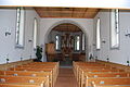
Reformed Church, interior view

Catholic chapel

Roundabout in the village center
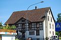
Half-timbered house

Tobel-Affeltrangen railway station (1965)


economy
- Holzwerk Schneider Switzerland (branch)
- Blättler Holzbau GmbH
traffic
Affeltrangen is connected to the stations Tobel-Affeltrangen and Märwil with the express train stations Wil and Weinfelden via the Thurbo railway line and via the Publicar to the canton capital Frauenfeld .
Personalities
- Walter Bion (1830–1909), educator, Reformed theologian
- Arnold Dodel-Port (1843–1908), botanist
- Hans Thomann (1899–1988), military
- Josef Häfeli (* 1950), troubadour
Web links
Individual evidence
- ↑ Permanent and non-permanent resident population by year, canton, district, municipality, population type and gender (permanent resident population). In: bfs. admin.ch . Federal Statistical Office (FSO), August 31, 2019, accessed on December 22, 2019 .
- ↑ a b Thurgau in figures 2019 . On the website of the Statistical Office of the Canton of Thurgau (PDF file; 1.8 MB), accessed on April 28, 2020.
- ↑ Swiss land use statistics. Completed on July 1, 1912. Published by the Federal Statistical Bureau. ( Memento from April 12, 2016 in the Internet Archive )
- ↑ Philipp Obrist: Affeltrangen TG (Münchwilen) in: Dictionnaire toponymique des communes suisses - Lexicon of Swiss municipality names - Dizionario toponomastico dei comuni svizzeri (DTS | LSG). Center de dialectologie, Université de Neuchâtel, Verlag Huber, Frauenfeld / Stuttgart / Vienna 2005, ISBN 3-7193-1308-5 and Éditions Payot, Lausanne 2005, ISBN 2-601-03336-3 , p. 76. Specified phonetic transcription : ˈafl̬traŋːə
- ↑ a b Localities and their resident population. Edition 2019 . On the website of the Statistical Office of the Canton of Thurgau (Excel table; 0.1 MB), accessed on April 28, 2020.
-
↑ a b c d e f g
André Salathé: Affeltrangen. In: Historical Lexicon of Switzerland .
These sections are largely based on the entry in the Historical Lexicon of Switzerland (HLS), which, according to the HLS's usage information, is under the Creative Commons license - Attribution - Share under the same conditions 4.0 International (CC BY-SA 4.0). - ↑ StiASG , Urk. I 73. Online at e-chartae , accessed on June 12, 2020.
- ^ Charles Knapp, Maurice Borel, Victor Attinger, Heinrich Brunner, Société neuchâteloise de geographie (editor): Geographical Lexicon of Switzerland . Volume 1: Aa - Emmengruppe . Verlag Gebrüder Attinger, Neuenburg 1902, p. 24, keyword Affeltrangen ( scan of the lexicon page ).
- ↑ a b municipal coat of arms . On the website of the State Archives of the Canton of Thurgau, accessed on December 8, 2019
- ↑ a b c population development of the municipalities. Canton Thurgau, 1850–2000 and resident population of the municipalities and change from the previous year. Canton of Thurgau, 1990–2018. On the website of the Statistical Office of the Canton of Thurgau (Excel tables; 0.1 MB each), accessed on April 28, 2020.
Affeltrangen | Amlikon-Bissegg | Mountain | Birwinken | Bischofszell | Bürglen | Bussnang | Alder | Hauptwil-Gottshaus | Hohentannen | Kradolf-Schönenberg | Märstetten | Schönholzerswilen | Sulgen | Weinfelden | Wigoltingen | Wuppenau | Zihlschlacht-Sitterdorf
Former municipalities: Amlikon | Andhausen | Andwil | Bissegg | Bleiken | Bonau | Book at Märwil | Buchackern | Buhwil | Donzhausen | Engishofen | Engwang | Ennetaach | Friltschen | Götighofen | House of God | Graltshausen | Griesenberg | Guntershausen near Birwinken | Heaps | Happerswil book | Hauptwil | Holy Cross | Heldswil | Hessenreuti | Pants jerk | Illhart | Istighofen | Klarsreuti | Kradolf | Kümmertshausen | Lamperswil | Lanterswil | Leimbach | People mark | Märwil | Mattwil | Mettlen | Neukirch an der Thur | Oberbussnang | Opfershofen | Oppikon | Ottoberg | Reuti | Riedt | Rothenhausen | Schönenberg | Swiss wood | Sitterdorf | Strohwilen | Toos | Weerswilen | Zezikon | Zihlschlacht
Canton of Thurgau |
Districts of the Canton of Thurgau |
Municipalities of the Canton of Thurgau