
Happerswil book
| Happerswil book | ||
|---|---|---|
 |
||
| State : |
|
|
| Canton : |
|
|
| District : | Weinfelden | |
| Political community : | Birwinken | |
| Postal code : | 8585 | |
| former BFS no. : | 4904 | |
| Coordinates : | 734 297 / 271361 | |
| Height : | 528 m above sea level M. | |
| Area : | 3.07 km² | |
| Residents: | 247 (December 31, 2018) | |
| Population density : | 80 inhabitants per km² | |
.jpg) Happerswil |
||
| map | ||
|
||

From 1816 to 1994 Happerswil-Buch was a local parish of the municipality of Birwinken in the canton of Thurgau in Switzerland . The two villages of Happerswil and Buch near Kümmertshausen are located off the road on the southern slope of the Seerücken .
On January 1, 1995 , the local community of Happerswil-Buch merged as part of the Thurgau community reform to form the political community of Birwinken.
history

1159 Happerswil was mentioned in a document as Har (t) pretiswillare . In the 12th century, the St. Stephan Abbey in Happerswil owned land and rights. Until 1798 the hamlet was part of the lower court of Andwil , which belonged to the St. Stephan monastery. The lower court of Buch, however, was owned by the city of Constance before 1798 . From 1798 to 1803, Happerswil and Buch formed the municipality of Happerswil in the district of Gottlieben and Kreuzlingen . From 1803 to 1816 the two hamlets were part of the Illighausen municipality . In 1812 the local parishes of Happerswil and Buch were merged to form the local parish of Happerswil-Buch, which belonged to the municipal parish of Birwinken from 1816 to 1994.
Ecclesiastically, Happerswil and Buch were always under the parish of Langrickenbach and adopted the Reformed faith during the Reformation .
In the 19th century, arable and fruit growing was practiced, and a calico weaving mill was located in the community . Towards the end of the 19th century, there was a shift to cattle and dairy farming, and embroidery companies gained a foothold around 1900. Although some single-family houses have recently been built, Happerswil-Buch has retained its rural character.
coat of arms

Blazon : A red fox head in white .
The fox is the common heraldic figure for Happerswil and Buch. The Lords of Andwil , the oldest known landowners in Buch, used the fox as a helmet ornament and partly in their coat of arms. The fox was also the heraldic animal of the Lords of Steinach , who owned the Bailiwick of Happerswil around the middle of the 14th century . The colors red and white come from the tithe lord , the Hochstift Konstanz .
population
Of the total of 184 inhabitants in the village of Happerswil in 2018, 13 or 7.1% were foreign nationals. 117 (63.6%) were Protestant Reformed and 19 (10.3%) were Roman Catholic. Of the 63 inhabitants of the village of Buch, 36 (57.1%) were Protestant Reformed and 9 (14.3%) were Roman Catholic in the same year.
| year | 1850 | 1888 | 1900 | 1950 | 1980 | 1990 | 2000 | 2010 | 2018 |
|---|---|---|---|---|---|---|---|---|---|
| Local parish | 331 | 359 | 259 | 234 | 177 | 217 | |||
| Happerswil locality | 169 | 173 | 184 | ||||||
| Buch | 54 | 52 | 63 | ||||||
| source | |||||||||
photos
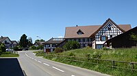
Happerswil

Happerswil village fountain

Book with Kümmertshausen

Book with Kümmertshausen
.jpg)
.jpg)
.jpg)

literature
- Verena Rothenbühler: Happerswil book. In: Historical Lexicon of Switzerland .
This article is largely based on the entry in the Historisches Lexikon der Schweiz (HLS), which, according to the HLS's usage information, is licensed under the Creative Commons - Attribution - Distribution under the same conditions 4.0 International (CC BY-SA 4.0) license .
Individual evidence
- ↑ Swiss land use statistics. Completed on July 1, 1912. Published by the Federal Statistical Bureau. ( Memento from April 12, 2016 in the Internet Archive )
- ↑ a b c d Localities and their resident population. Edition 2019 . On the website of the Statistical Office of the Canton of Thurgau (Excel table; 0.1 MB), accessed on April 28, 2020.
- ↑ a b Coat of arms of Happerswil-Buch. On the website of the municipality of Birwinken, accessed on February 15, 2020
- ↑ Locations and Settlements Directory. Canton of Thurgau, 2005 edition . On the website of the Statistical Office of the Canton of Thurgau (PDF; 1.7 MB), accessed on April 28, 2020.
- ↑ Locations and Settlements Directory. Canton of Thurgau, 2012 edition. On the website of the Statistical Office of the Canton of Thurgau (PDF; 3.4 MB), accessed on May 11, 2020.
Affeltrangen | Amlikon-Bissegg | Mountain | Birwinken | Bischofszell | Bürglen | Bussnang | Alder | Hauptwil-Gottshaus | Hohentannen | Kradolf-Schönenberg | Märstetten | Schönholzerswilen | Sulgen | Weinfelden | Wigoltingen | Wuppenau | Zihlschlacht-Sitterdorf
Former municipalities: Amlikon | Andhausen | Andwil | Bissegg | Bleiken | Bonau | Book at Märwil | Buchackern | Buhwil | Donzhausen | Engishofen | Engwang | Ennetaach | Friltschen | Götighofen | House of God | Graltshausen | Griesenberg | Guntershausen near Birwinken | Heaps | Happerswil book | Hauptwil | Holy Cross | Heldswil | Hessenreuti | Pants jerk | Illhart | Istighofen | Klarsreuti | Kradolf | Kümmertshausen | Lamperswil | Lanterswil | Leimbach | People mark | Märwil | Mattwil | Mettlen | Neukirch an der Thur | Oberbussnang | Opfershofen | Oppikon | Ottoberg | Reuti | Riedt | Rothenhausen | Schönenberg | Swiss wood | Sitterdorf | Strohwilen | Toos | Weerswilen | Zezikon | Zihlschlacht
Canton of Thurgau |
Districts of the Canton of Thurgau |
Municipalities of the Canton of Thurgau