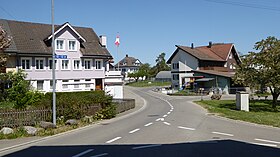
Reuti TG
| TG is the abbreviation for the canton of Thurgau in Switzerland and is used to avoid confusion with other entries of the name Reuti . |
| Reuti | ||
|---|---|---|
| State : |
|
|
| Canton : |
|
|
| District : | Weinfelden | |
| Political community : | Bussnang | |
| Postal code : | 9565 | |
| former BFS no. : | 4928 | |
| Coordinates : | 726 866 / 267 348 | |
| Height : | 470 m above sea level M. | |
| Area : | 1.56 km² | |
| Residents: | 122 (1990) | |
| Population density : | 78 inhabitants per km² | |
|
Reuti TG |
||
| map | ||
|
|
||
Reuti , in Swiss German Rüüti , is a former municipality and a settlement of the municipality of Bussnang in the Weinfelden district of the canton of Thurgau in Switzerland .
From 1803 to 1995 the local community Reuti belonged to the municipal community Bussnang and comprised the farming village Reuti and the Kirchdörflein Wertbühl, about 2 kilometers away south of the Thur . On January 1, 1995 , the local community Reuti merged as part of the Thurgau community reform to form the political community Bussnang.
history
From the High Middle Ages until 1798, Reuti and Wertbühl belonged to the Lower Court of Mettlen and the Bürglen rule . Ecclesiastically, Reuti was always part of Wertbühl, where the Catholics remained parish even after the Reformation . The few Reformed Churches visited neighboring churches from 1529 to which they were permanently assigned in the 19th century: Reuti zu Bussnang, Wertbühl zu Bürglen .
Grain cultivation was carried out as part of the three - tier economy , alongside viticulture , and from the mid-19th century onwards, increased cattle and dairy farming as well as fruit growing. Reuti retained its rural character.
coat of arms
Blazon : split by yellow , with a blue trunk with four cut branches, and red, with a white jug with a handle.
The yellow-blue half is a talking coat of arms for Reuti in the colors of Bürglen. The red and white half shows the jug of St. Verena , the church patroness of Wertbühl, in the colors of the cathedral monastery of Constance .
population
| year | 1850 | 1900 | 1950 | 1990 | 2000 | 2010 | 2018 |
| Local parish | 134 | 101 | 116 | 122 | |||
| Locality | 59 | 48 | 52 | ||||
| source | |||||||
Attractions
→ see section Sights in the article Wertbühl
literature
- André Salathé: Reuti. In: Historical Lexicon of Switzerland .
This article is largely based on the entry in the Historisches Lexikon der Schweiz (HLS), which, according to the HLS's usage information, is licensed under the Creative Commons - Attribution - Distribution under the same conditions 4.0 International (CC BY-SA 4.0) license .
Web links
Individual evidence
- ↑ Swiss land use statistics. Completed on July 1, 1912. Published by the Federal Statistical Bureau. ( Memento from April 12, 2016 in the Internet Archive )
- ^ A b André Salathé: Reuti. In: Historical Lexicon of Switzerland .
- ↑ Reuti Auf ortsnames.ch (online database), accessed on February 15, 2020
- ↑ Localities and their resident population. Edition 2019 . On the website of the Statistical Office of the Canton of Thurgau (Excel table; 0.1 MB), accessed on April 28, 2020.
- ↑ a b Bussnang - the municipality with train On the website of the municipality Bussnang, 2009, p. 15 (PDF; 5.0 MB)
- ↑ Locations and Settlements Directory. Canton of Thurgau, 2005 edition . On the website of the Statistical Office of the Canton of Thurgau (PDF; 1.7 MB), accessed on April 28, 2020.
- ↑ Locations and Settlements Directory. Canton of Thurgau, 2012 edition. On the website of the Statistical Office of the Canton of Thurgau (PDF; 3.4 MB), accessed on May 11, 2020.
- ↑ List of settlements. Canton of Thurgau, edition 2019 . On the website of the Statistical Office of the Canton of Thurgau (Excel table; 0.2 MB), accessed on May 10, 2020.


