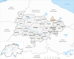
Graltshausen
| Graltshausen | ||
|---|---|---|
| State : |
|
|
| Canton : |
|
|
| District : | Weinfelden | |
| Political community : | mountain | |
| Postal code : | 8572 | |
| former BFS no. : | 4893 | |
| Coordinates : | 731 138 / 273 136 | |
| Height : | 540 m above sea level M. | |
| Area : | 1.60 km² | |
| Residents: | 93 (December 31, 2018) | |
| Population density : | 58 inhabitants per km² | |
| map | ||
|
|
||
Graltshausen is a former parish and a village in the Swiss canton of Thurgau . Since January 1st 1995 it belongs to the political municipality Berg .
The local community Graltshausen belonged to the municipality of Hugelshofen between 1803 and 1865 and to that of Berg from 1866 to 1994.
geography
The cluster village is located on the Seerücken northwest of Berg away from the traffic routes. From 1816 the hamlet of Lanzendorn also belonged to the local community of Graltshausen.
Neighboring towns are Weinfelden , Lengwil , Kemmental , Bürglen and Birwinken .
history
The village was first mentioned on September 24, 1245 as Grailsshusen . In the early Middle Ages it was in the Konstanzer Bischofshöri and from the Middle Ages until 1798 it was under the Eggen Bailiwick . Lanzendorn, on the other hand, was a high court before 1798 , which was subordinate to the federal governor in Thurgau by high and low court.
Religion
The majority Reformed Graltshausen always belonged to the parish or to the parish of Alterswilen and shared their fate. For the Catholics , the Berg parish is responsible for the village.
population
Of the total of 93 inhabitants in the village of Graltshausen in 2018, 50 (53.8%) were Protestant Reformed and 20 (21.5%) were Roman Catholic.
| year | 1850 | 1880 | 1900 | 1950 | 1990 | 2000 | 2010 | 2018 |
|---|---|---|---|---|---|---|---|---|
| Local parish | 153 | 108 | 146 | 136 | 95 | |||
| Locality | 106 | 87 | 93 | |||||
| source | ||||||||
economy
Agriculture dominated the community until the end of the 19th century . This was then replaced by cattle breeding , dairy farming and fruit growing . In 1889 the cheese cooperative Graltshausen-Altishausen was founded, which was closed again in 2004. A forest nursery that opened in the second half of the 19th century also contributes to the local economy.
traffic
The village is not connected to public transport by train or bus .
Attractions
The farmhouse at Bergstrasse 2 is one of Berg's cultural assets .
literature
Verena Rothenbühler: Graltshausen. In: Historical Lexicon of Switzerland .
This article is largely based on the entry in the Historisches Lexikon der Schweiz (HLS), which, according to the HLS's usage information, is licensed under the Creative Commons - Attribution - Distribution under the same conditions 4.0 International (CC BY-SA 4.0) license .
Web links
- Graltshausen on the nenet.ch website
Individual evidence
- ↑ Swiss land use statistics. Completed on July 1, 1912. Published by the Federal Statistical Bureau. ( Memento from April 12, 2016 in the Internet Archive )
- ↑ a b c d Localities and their resident population. Edition 2019 . On the website of the Statistical Office of the Canton of Thurgau (Excel table; 0.1 MB), accessed on April 28, 2020.
- ↑ Locations and Settlements Directory. Canton of Thurgau, 2005 edition . On the website of the Statistical Office of the Canton of Thurgau (PDF; 1.7 MB), accessed on April 28, 2020.
- ↑ Locations and Settlements Directory. Canton of Thurgau, 2012 edition. On the website of the Statistical Office of the Canton of Thurgau (PDF; 3.4 MB), accessed on May 11, 2020.
- ^ History of Graltshausen. Retrieved August 10, 2014 .
Remarks
- ↑ with outside courtyards


