
Märstetten
| Märstetten | |
|---|---|
 |
|
| State : |
|
| Canton : |
|
| District : | Weinfelden |
| BFS no. : | 4941 |
| Postal code : | 8560 |
| UN / LOCODE : | CH MAR |
| Coordinates : | 722 553 / 272518 |
| Height : | 425 m above sea level M. |
| Height range : | 410–650 m above sea level M. |
| Area : | 9.96 km² |
| Residents: | 2898 (December 31, 2018) |
| Population density : | 291 inhabitants per km² |
| Website: | www.maerstetten.ch |
| Location of the municipality | |
  |
|
Märstetten is a municipality in the district of Weinfelden in the canton of Thurgau in Switzerland . Märstetten is a clustered village with the hamlets of Boltshausen, Altenburg, Dattenhub and Ruberbaum at the western foot of the Ottenberg.
From 1803 the local communities Märstetten and Ottoberg formed the municipal community Märstetten. In 1975 these merged to form the unitary community of Märstetten.
history


Litter finds from the Neolithic , remains of Roman walls and a row grave from the early Middle Ages are evidence of uninterrupted settlement. Marsteten was first mentioned in a document in 1155 . In the High Middle Ages , the castle of the Barons von Märstätten was located above the church . The Domstift Konstanz enfeoffed the Barons von Klingen with Märstätten, Illhart and Wigoltingen around 1155 . Märstätten formed a court and in 1724 included part of Ruberbaum and a few other courtyards. Appellation instances were the court of Lord of the rule Altenklingen , after 1460 the thurgische bailiff and the Federal Diet . In 1395 Wilhelm von Enne was the owner of the judiciary, followed by the Muntprat from 1419, the von Breiten landenberg from 1441, the Brümsi from 1559, Leonhart Zollikofer from 1585 and other members of his family until 1798. Märstätten was subject to a ten-year fee for the Constance Cathedral. Canon Salomon Buchhorner had a new Kehlhof built in 1613 , the catchment area of which consisted of Boltshausen, Illhart, Sonterswil , Märstätten and Ottoberg. Until 1798 the so-called inner community included Märstätten, the outer community Ottoberg and the outer courtyards. From 1860 the citizens and residents gathered at Hilarius (January 13th) for the citizens , local and school community , for the Gant and for the so-called Hilärimahl.
The church of St. Jakob on the pilgrimage route Konstanz – Einsiedeln was an own church of the barons of Märstätten. In 1155 it belonged to the property of the cathedral monastery of Konstanz. From 1242 to 1487 the church was a branch of Wigoltingen. Without the consent of the ruling places, Märstätten separated from the mother church in 1465, which was confirmed in 1487. 1482 procured Märstätten with Pope Sixtus IV. A bull with the right to a secular priest to hire. The Reformation prevailed in 1529. From 1594 to 1795 the Catholic mass was also read again.
Until 1900, Märstätten was characterized by arable, flax, fruit and wine growing, then cattle and dairy farming followed. In 1909 a cheese dairy was established. In addition, the trade as well as the linen and cotton weaving brought a profit. In 1855 the Nordostbahn started operating, after which an industrial quarter was built near the station. In 1884, the Märstätten glue and fertilizer factory, which existed until 1976, was founded, from 1885 to 1888 and from 1900 to 1924 there was embroidery, a.o. a. a monogram embroidery. In 1968 the Cooperative Grain Collection Center Mittelthurgau was launched, which in 2001 became Getreide Mittelthurgau AG. The Polygal chemical factory, founded in 1956, specializes in the manufacture of products based on vegetable raw materials.
→ see also section history in the article Ottoberg TG
coat of arms
Blazon : Split from black with a white lion with a red tongue and claws and white with a half black eagle with a red beak, tongue and foot.
The coat of arms is that of the free von Märstetten, as shown in Johannes Stumpf's chronicle . After the local communities of Märstetten and Ottoberg merged to form the unified community of Märstetten in 1975, the coat of arms was continued to be used for the new community.
population
 |
| 1850 | 1900 | 1950 | 1960 | 1980 | 2000 | 2010 | 2018 | |
|---|---|---|---|---|---|---|---|---|
| Political community | 1568 | 2234 | 2480 | 2885 | ||||
| Municipal parish | 1009 | 1030 | 1251 | 1278 | ||||
| Local parish | 490 | 539 | 832 | 922 | ||||
| source | ||||||||
Of the total of 2,885 inhabitants in the municipality of Märstetten in 2018, 398 or 13.8% were foreign nationals. 1212 (42.0%) were Protestant Reformed and 717 (24.9%) were Roman Catholic. The village of Märstetten had 2334 inhabitants at that time. Of these, 51 belonged to the municipality of Wigoltingen (including in Egelshofen and Altenklingen ) .
economy
In 2016 Märstetten offered work for 828 people (converted to full-time positions). 9.4% of them worked in agriculture and forestry, 39.5% in industry, trade and construction and 51.1% in the service sector.
traffic
Märstetten is located at the intersection of Hauptstrasse 14 between Frauenfeld and Amriswil and Hauptstrasse 16 between Konstanz and Wil SG . Märstetten has a train station on the SBB line through the Thur Valley .
Attractions
The villages of Märstetten and Ottoberg , the hamlet of Boltshausen and the southern slope of the Ottenberg are listed in the inventory of places worth protecting in Switzerland .
Personalities
- Abraham Roth (1823–1880), editor
- Otto Herrmann (1890–1965), politician ( SP )
- Karl Meuli (1891–1968), classical philologist and folklorist
photos
→ See also the Sights and Pictures sections in the Ottoberg TG article
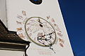
Sundial on the church tower

Medieval frescoes in the church

Well and old bell in the cemetery
Pilgrims' hostel in Märstetten

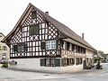
Half-timbered villa

Center of Ottoberg TG

Half-timbered house in Ottoberg
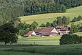
Hamlet forest


Web links
- Official website of the municipality of Märstetten
- Information on the history and on living and working in Märstetten
Individual evidence
- ↑ Permanent and non-permanent resident population by year, canton, district, municipality, population type and gender (permanent resident population). In: bfs. admin.ch . Federal Statistical Office (FSO), August 31, 2019, accessed on December 22, 2019 .
- ↑ a b Thurgau in figures 2019 . On the website of the Statistical Office of the Canton of Thurgau (PDF file; 1.8 MB), accessed on April 28, 2020.
- ↑ Swiss land use statistics. Completed on July 1, 1912. Published by the Federal Statistical Bureau. ( Memento from April 12, 2016 in the Internet Archive )
- ↑ a b c population development of the municipalities. Canton Thurgau, 1850–2000 and resident population of the municipalities and change from the previous year. Canton of Thurgau, 1990–2018. On the website of the Statistical Office of the Canton of Thurgau (Excel tables; 0.1 MB each), accessed on April 28, 2020.
- ^ History. On the website of the municipality of Märstetten, accessed on November 1, 2019
-
↑ a b c d Erich Trösch: Märstetten. In: Historical Lexicon of Switzerland .
These sections are largely based on the entry in the Historical Lexicon of Switzerland (HLS), which, according to the HLS's usage information, is under the Creative Commons license - Attribution - Share under the same conditions 4.0 International (CC BY-SA 4.0). - ↑ a b municipal coat of arms . On the website of the State Archives of the Canton of Thurgau, accessed on December 8, 2019
- ↑ Localities and their resident population. Edition 2019 . On the website of the Statistical Office of the Canton of Thurgau (Excel table; 0.1 MB), accessed on April 28, 2020.
Affeltrangen | Amlikon-Bissegg | Mountain | Birwinken | Bischofszell | Bürglen | Bussnang | Alder | Hauptwil-Gottshaus | Hohentannen | Kradolf-Schönenberg | Märstetten | Schönholzerswilen | Sulgen | Weinfelden | Wigoltingen | Wuppenau | Zihlschlacht-Sitterdorf
Former municipalities: Amlikon | Andhausen | Andwil | Bissegg | Bleiken | Bonau | Book at Märwil | Buchackern | Buhwil | Donzhausen | Engishofen | Engwang | Ennetaach | Friltschen | Götighofen | House of God | Graltshausen | Griesenberg | Guntershausen near Birwinken | Heaps | Happerswil book | Hauptwil | Holy Cross | Heldswil | Hessenreuti | Pants jerk | Illhart | Istighofen | Klarsreuti | Kradolf | Kümmertshausen | Lamperswil | Lanterswil | Leimbach | People mark | Märwil | Mattwil | Mettlen | Neukirch an der Thur | Oberbussnang | Opfershofen | Oppikon | Ottoberg | Reuti | Riedt | Rothenhausen | Schönenberg | Swiss wood | Sitterdorf | Strohwilen | Toos | Weerswilen | Zezikon | Zihlschlacht
Canton of Thurgau |
Districts of the Canton of Thurgau |
Municipalities of the Canton of Thurgau
← Previous location: Lippoldswilen | Märstetten | Next town: Amlikon →