Kradolf
| Kradolf | ||
|---|---|---|
| State : |
|
|
| Canton : |
|
|
| District : | Weinfelden | |
| Political community : | Kradolf-Schönenberg | |
| Postal code : | 9214 | |
| former BFS no. : | 4508 | |
| Coordinates : | 732 821 / 265 399 | |
| Height : | 455 m above sea level M. | |
| Area : | 1.76 km² | |
| Residents: | 1438 (December 31, 2018) | |
| Population density : | 817 inhabitants per km² | |
| map | ||
|
|
||
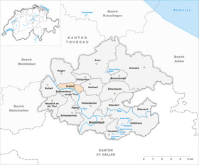
Kradolf is a village on the Weinfelden - Bischofszell traffic connection in the municipality of Kradolf-Schönenberg in the Weinfelden district in the Swiss canton of Thurgau . Until 1995 Kradolf was a local church in the municipal municipality Sulgen .
On January 1, 1996 Kradolf separated from the Munizipalgemeinde Sulgen and merged with the hitherto to Munizipalgemeinde Neukirch an der Thur belonging to local churches Buhwil , Neukirch an der Thur Schönenberg an der Thur and some of the local church Schweizersholz separate hamlets to political community Kradolf- Schönenberg.
geography
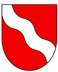
Kradolf is on the right bank of the Thur , where the previously untamed river enters the plain. The Thur used to find its own way and its floods repeatedly led the population into great hardship. Today a flood protection dam protects the houses in Kradolf and Schönenberg from flooding. The close relationship to the Thur is also expressed in the local coat of arms of Kradolf and in the municipal coat of arms of Kradolf-Schönenberg.
The road connection Sulgen - Gossau SG and the parallel railway line Weinfelden - St. Gallen with a train station in town.
history
Kradolf was first mentioned in a document in 883 as Chreinthorf in connection with possessions of the St. Gallen monastery . In 1276 the spelling Kraedorf is documented. From 1360 to 1798 Kradolf belonged to the Schönenberg office of the Bishop of Constance , which was administered by the Obervogtei in Bischofszell . According to Sulgen, the population was always church-related, whose church was used equally after the Reformation until a reformed church was built in Kradolf in 1975 .
Until 1880 agriculture with dairy farming, fruit growing and viticulture as well as small businesses determined the economic structure. With the opening of the Bischofszellerbahn in 1876 and the boom in a silk weaving mill in Schönenberg an der Thur, the employment structure changed in favor of the second economic sector , which in 1920 provided 78% of jobs. The oldest factories in Kradolf are the Otto Dünner pottery factory (1904–1999) and the Robert Ernst (1858–1992) pasta factory and oat mill. With 75 employees in Kradolf, the Humbel gear factory is the second largest employer in the community today. Today, in addition to the residential buildings, various commercial enterprises shape the appearance of the street village.
coat of arms
Blazon : in red a sloping white wavy bar .
The coat of arms is a new creation from 1933.
population
| year | 1850 | 1880 | 1900 | 1920 | 1950 | 1990 | 2000 | 2010 | 2018 |
| Local parish | 147 | 228 | 649 | 1064 | 983 | 1183 | |||
| Locality | 1144 | 1043 | 1438 | ||||||
| source | |||||||||
Of the total of 1,438 inhabitants in the village of Kradolf in 2018, 480 or 33.4% were foreign nationals. 394 (27.4%) were Protestant Reformed and 362 (25.2%) were Roman Catholic.
Attractions
The cable-stayed bridge over the Thur to Schönenberg, inaugurated in 1998, is a landmark of Kradolf.
Personalities
- Willi Oertig , painter
- Werner Messmer , former member of the FDP National Council, President of the Swiss Association of Builders
- Karl Meier (actor) , editor of the «Kreis»
Web links
Individual evidence
- ↑ Swiss land use statistics. Completed on July 1, 1912. Published by the Federal Statistical Bureau. ( Memento from April 12, 2016 in the Internet Archive )
- ↑ a b c d Localities and their resident population. Edition 2019 . On the website of the Statistical Office of the Canton of Thurgau (Excel table; 0.1 MB), accessed on April 28, 2020.
- ↑ Population development of the municipalities. Canton of Thurgau, 1850-2000. On the website of the Statistical Office of the Canton of Thurgau (Excel table; 0.1 MB), accessed on April 28, 2020.
- ↑ a b c d story. On the website of the municipality of Kradolf-Schönenberg, accessed on November 18, 2019
- ↑ StiASG , Urk. II 145. Online at e-chartae , accessed on June 25, 2020.
-
↑ a b c d Erich Trösch: Schönenberg on the Thur. In: Historical Lexicon of Switzerland .
These sections are largely based on the entry in the Historical Lexicon of Switzerland (HLS), which, according to the HLS's usage information, is under the Creative Commons license - Attribution - Share under the same conditions 4.0 International (CC BY-SA 4.0). - ↑ a b municipal coat of arms . On the website of the State Archives of the Canton of Thurgau, accessed on December 8, 2019
- ↑ Locations and Settlements Directory. Canton of Thurgau, 2005 edition . On the website of the Statistical Office of the Canton of Thurgau (PDF; 1.7 MB), accessed on April 28, 2020.
- ↑ Locations and Settlements Directory. Canton of Thurgau, 2012 edition. On the website of the Statistical Office of the Canton of Thurgau (PDF; 3.4 MB), accessed on May 11, 2020.
Remarks
- ↑ with outside courtyards


