
Ennetaach
| Ennetaach | ||
|---|---|---|
 |
||
| State : |
|
|
| Canton : |
|
|
| District : | Weinfelden | |
| Political community : | Alder TG | |
| Postal code : | 8586 | |
| former BFS no. : | 4476 | |
| Coordinates : | 733 784 / 267 993 | |
| Height : | 451 m above sea level M. | |
| Height range : | 438–558 m above sea level M. | |
| Area : | 12.19 km² | |
| Residents: | 281 (December 31, 2018) | |
| Population density : | 23 inhabitants per km² | |
 Ennetaach |
||
| Location of the municipality | ||
|
||

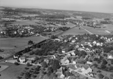
Ennetaach is a village in the municipality of Erlen in the canton of Thurgau in Switzerland . The Ennetaach, which today has almost grown together with alders, formed from 1804 to 1994 a local community of the former municipal community of Erlen.
history
Before 1798 Ennetaach was under the Lower Court of Hessenreuti , one house belonged to the Oberaach rule . In the 18th century the settlement was called Enet-Eich . Ennetaach was always in the parish of Sulgen . The Reformed population has been part of the Erlen parish since 1965. In Ennetaach, a community of Reformed baptismal people was formed in the early 19th century . Ennetaach regarded itself as an independent municipality as early as 1756.
Fruit growing, dairy farming and retail trade were the main sources of income for the inhabitants in the 19th century. Around 1900 a cotton twining mill set up shop which , together with other companies, has changed the social structure of Ennetaach permanently since 1950. In 1990, the second economic sector provided 85% of jobs in Ennetaach.
population
| year | 1850 | 1870 | 1900 | 1950 | 1990 | 2000 | 2010 | 2018 |
| Local parish | 123 | 98 | 143 | 225 | 470 | |||
| Locality | 484 | 261 | 281 | |||||
| source | ||||||||
.jpg)

Of the total of 281 inhabitants in the town of Ennetaach in 2018, 63 or 22.4% were foreign nationals. 97 (34.5%) were Protestant Reformed and 84 (29.9%) were Roman Catholic.
literature
- Verena Rothenbühler: Ennetaach. In: Historical Lexicon of Switzerland .
This article is largely based on the entry in the Historisches Lexikon der Schweiz (HLS), which, according to the HLS's usage information, is licensed under the Creative Commons - Attribution - Distribution under the same conditions 4.0 International (CC BY-SA 4.0) license .
Web links
Individual evidence
- ↑ a b c d Localities and their resident population. Edition 2019 . On the website of the Statistical Office of the Canton of Thurgau (Excel table; 0.1 MB), accessed on April 28, 2020.
- ↑ Swiss land use statistics. Completed on July 1, 1912. Published by the Federal Statistical Bureau. ( Memento from April 12, 2016 in the Internet Archive )
- ↑ Locations and Settlements Directory. Canton of Thurgau, 2005 edition . On the website of the Statistical Office of the Canton of Thurgau (PDF; 1.7 MB), accessed on April 28, 2020.
- ↑ Locations and Settlements Directory. Canton of Thurgau, 2012 edition. On the website of the Statistical Office of the Canton of Thurgau (PDF; 3.4 MB), accessed on May 11, 2020.
Affeltrangen | Amlikon-Bissegg | Mountain | Birwinken | Bischofszell | Bürglen | Bussnang | Alder | Hauptwil-Gottshaus | Hohentannen | Kradolf-Schönenberg | Märstetten | Schönholzerswilen | Sulgen | Weinfelden | Wigoltingen | Wuppenau | Zihlschlacht-Sitterdorf
Former municipalities: Amlikon | Andhausen | Andwil | Bissegg | Bleiken | Bonau | Book at Märwil | Buchackern | Buhwil | Donzhausen | Engishofen | Engwang | Ennetaach | Friltschen | Götighofen | House of God | Graltshausen | Griesenberg | Guntershausen near Birwinken | Heaps | Happerswil book | Hauptwil | Holy Cross | Heldswil | Hessenreuti | Pants jerk | Illhart | Istighofen | Klarsreuti | Kradolf | Kümmertshausen | Lamperswil | Lanterswil | Leimbach | People mark | Märwil | Mattwil | Mettlen | Neukirch an der Thur | Oberbussnang | Opfershofen | Oppikon | Ottoberg | Reuti | Riedt | Rothenhausen | Schönenberg | Swiss wood | Sitterdorf | Strohwilen | Toos | Weerswilen | Zezikon | Zihlschlacht
Canton of Thurgau |
Districts of the Canton of Thurgau |
Municipalities of the Canton of Thurgau