
Sitterdorf
| Sitterdorf | ||
|---|---|---|
 |
||
| State : |
|
|
| Canton : |
|
|
| District : | Weinfelden | |
| Political community : | Zihlschlacht-Sitterdorf | |
| Postal code : | 8589 | |
| former BFS no. : | 4517 | |
| Coordinates : | 735 634 / 262627 | |
| Height : | 470 m above sea level M. | |
| Area : | 7.40 km² | |
| Residents: | 982 (1990) | |
| Population density : | 133 inhabitants per km² | |
| map | ||
|
||

Sitterdorf is a former municipality and a village in the municipality of Zihlschlacht-Sitterdorf in the Weinfelden district of the canton of Thurgau in Switzerland . Sitterdorf is located on the Sitter between Bischofszell and Amriswil .
On January 1, 1997 , the former municipality merged with Zihlschlacht to form the municipality of Zihlschlacht-Sitterdorf.
history


Sitterdorf was already settled in Roman times, because in 1861 a Roman villa was excavated. In 787 the Sitterdorf farm was first mentioned as Sidruna and from 787 it belonged to the St. Gallen monastery and from 898 to St. Mangen in St. Gallen. The Truchsessen of Singenberg were enfeoffed with the Vogtei until around 1250 . From the 15th century to 1798 the lower court , appellation and team rights of the Malefizgericht von Sitterdorf belonged to the Abbot of St. Gallen.
The church of St. Martin, mentioned from 1215, was rebuilt in 1515 and renovated in 1964. The collage came to Ryff in 1419, to Hallwyl's in 1570 and to St. Gallen Abbey in 1734. After the Reformation in 1528, the mass was reintroduced in 1567 and the church was used simultaneously until 1961, until the Catholics received their own house of worship in the church of Maria Königin .
Sitterdorf grew grain in three tents ; mills are mentioned from 1277 onwards. From the 19th century cattle and dairy farming (cheese dairies) as well as fruit and horticulture were operated. The trade offered work, u. a. the paper production in Degenau , embroidery and from 1920 to 1834 a shoe factory. In 1935, after years of efforts, Sitterdorf received a stop on the Sulgen – Gossau railway line . In 1955, Blidegg , Sitterdorf and Zihlschlacht merged to form the first final year community of the Canton of Thurgau. The airfield has existed since 1963.
coat of arms
Blazon : A white deer hull in blue .
The white stag in blue was the coat of arms of the Truchsessen von Singenberg.
population
| year | 1831 | 1850 | 1900 | 1950 | 1990 | 2000 | 2010 | 2018 |
| Local parish | 582 | 695 | 738 | 850 | 982 | |||
| Locality | 715 | 749 | 902 | |||||
| source | ||||||||
Of the total of 902 inhabitants of the village of Sitterdorf in 2018, 138 or 15.3% were foreign nationals. 325 (36.0%) were Roman Catholic and 302 (33.5%) Protestant Reformed.
Attractions

The most important sight is the chapel of St. Nikolaus and St. Magdalena from the 12th to 16th centuries near the hamlet of Degenau on the old pilgrimage route to the Sitter with wall paintings from the 12th century. From the Degenau, the Gertau – Degenau ferry leads over the Sitter to Gertau in the neighboring municipality of Hauptwil-Gottshaus .
The castle of the same name with a listed garden is located in Blidegg . Sitterdorf is also known for its small Sitterdorf airfield .
photos
_334.JPG)

Catholic Church of St. Mary Queen
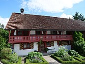
Old Catholic rectory

Sitterdorf airfield with amusement park


Web links
Individual evidence
- ↑ Swiss land use statistics. Completed on July 1, 1912. Published by the Federal Statistical Bureau. ( Memento from April 12, 2016 in the Internet Archive )
-
↑ a b c d e f g h Erich Trösch: Sitterdorf. In: Historical Lexicon of Switzerland .
These sections are largely based on the entry in the Historical Lexicon of Switzerland (HLS), which, according to the HLS's usage information, is under the Creative Commons license - Attribution - Share under the same conditions 4.0 International (CC BY-SA 4.0). - ↑ Localities and their resident population. Edition 2019 . On the website of the Statistical Office of the Canton of Thurgau (Excel table; 0.1 MB), accessed on April 28, 2020.
- ↑ StiASG , Urk. I 97. Online at e-chartae , accessed on June 12, 2020.
- ↑ Parish Church of St. Maria Sitterdorf. On the website of the Pastoralraum Bischofsberg, accessed on November 1, 2019
- ↑ History and Visions. On the website of the municipality of Zihlschlacht-Sitterdorf, accessed on November 1, 2019
- ↑ a b municipal coat of arms . On the website of the State Archives of the Canton of Thurgau, accessed on December 8, 2019
- ↑ Locations and Settlements Directory. Canton of Thurgau, 2005 edition . On the website of the Statistical Office of the Canton of Thurgau (PDF; 1.7 MB), accessed on April 28, 2020.
- ↑ Locations and Settlements Directory. Canton of Thurgau, 2012 edition. On the website of the Statistical Office of the Canton of Thurgau (PDF; 3.4 MB), accessed on May 11, 2020.
- ↑ Degenau Chapel. On the website of the Pastoralraum Bischofsberg, accessed on November 1, 2019
Remarks
- ↑ with outside courtyards
Affeltrangen | Amlikon-Bissegg | Mountain | Birwinken | Bischofszell | Bürglen | Bussnang | Alder | Hauptwil-Gottshaus | Hohentannen | Kradolf-Schönenberg | Märstetten | Schönholzerswilen | Sulgen | Weinfelden | Wigoltingen | Wuppenau | Zihlschlacht-Sitterdorf
Former municipalities: Amlikon | Andhausen | Andwil | Bissegg | Bleiken | Bonau | Book at Märwil | Buchackern | Buhwil | Donzhausen | Engishofen | Engwang | Ennetaach | Friltschen | Götighofen | House of God | Graltshausen | Griesenberg | Guntershausen near Birwinken | Heaps | Happerswil book | Hauptwil | Holy Cross | Heldswil | Hessenreuti | Pants jerk | Illhart | Istighofen | Klarsreuti | Kradolf | Kümmertshausen | Lamperswil | Lanterswil | Leimbach | People mark | Märwil | Mattwil | Mettlen | Neukirch an der Thur | Oberbussnang | Opfershofen | Oppikon | Ottoberg | Reuti | Riedt | Rothenhausen | Schönenberg | Swiss wood | Sitterdorf | Strohwilen | Toos | Weerswilen | Zezikon | Zihlschlacht
Canton of Thurgau |
Districts of the Canton of Thurgau |
Municipalities of the Canton of Thurgau