
Ottoberg TG
| TG is the abbreviation for the canton of Thurgau in Switzerland and is used to avoid confusion with other entries of the name Ottoberg . |
| Ottoberg | ||
|---|---|---|
 |
||
| State : |
|
|
| Canton : |
|
|
| District : | Weinfelden | |
| Political community : | Märstetten | |
| Postal code : | 8561 | |
| former BFS no. : | 4942 | |
| Coordinates : | 723 896 / 272 123 | |
| Height : | 517 m above sea level M. | |
| Area : | 4.82 km² | |
| Residents: | 602 (December 31, 2018) | |
| Population density : | 125 inhabitants per km² | |
 Ottoberg TG |
||
| map | ||
|
||

Ottoberg is a former municipality and a village in the municipality of Märstetten in the Weinfelden district of the canton of Thurgau in Switzerland .
Ottoberg was from 1803 to 1974 a local community within the municipality of Märstetten. Until 1 January 1975 merged the local church Otto mountain with the local and the Munizipalgemeinde Märstetten for unified community Märstetten.
geography
Ottoberg lies on the south-western slope of the Ottenberg against the Thur valley . The local community consisted of the farming villages of Ottoberg and Boltshausen and various hamlets such as Dattenhub or Ruberbaum.
history

In 1997 the Roman estate, which was discovered in 1795, was examined again in Boltshausen and coins from the 4th century and terrazzo fragments were found. Ottinberch was first mentioned in a document around 990, when the Petershausen monastery received two vineyards near Ottoberg from Adelgoz von Märstetten. In the late Middle Ages , Boltshausen and Ottoberg were part of the so-called High Courts , which from 1460 were directly subordinate to the Thurgau governor . Five houses in Boltshausen belonged to the Weinfelden estate until 1798 .
Ecclesiastically, Ottoberg always shared the fate of the Märstetten parish ; at the beginning of the 21st century, Catholics were ecclesiastical in Weinfelden.
Ottoberg owned a parish hall at the end of the 18th century. Wine, meadow and fruit growing, forestry as well as cattle and timber trade were carried out.
population
| year | 1831 | 1850 | 1900 | 1950 | 1970 | 2000 | 2010 | 2018 |
| Local parish | 624 | 519 | 491 | 419 | 373 | |||
| Locality | 361 | 397 | 602 | |||||
| source | ||||||||
Of the total of 602 inhabitants in Ottoberg in 2018, 35 or 5.8% were foreign nationals. 283 (47.0%) were Protestant Reformed and 150 (24.9%) Roman Catholic.
Attractions
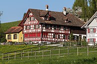
Ottoberg is listed in the inventory of places worth protecting in Switzerland . The former Trotte, the house in village 3 and the farmhouse on Schnellberg 3 are listed in the list of cultural assets in Märstetten .
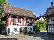
Former Trotte Dorf 2

House village 3

Schnellberg farmhouse 3


photos

Farmhouse village 4 and 6

Hauptstrasse 18 and 16

Schlössli
Rear ruber tree 6


literature
- Erich Trösch: Ottoberg. In: Historical Lexicon of Switzerland .
This article is largely based on the entry in the Historisches Lexikon der Schweiz (HLS), which, according to the HLS's usage information, is licensed under the Creative Commons - Attribution - Distribution under the same conditions 4.0 International (CC BY-SA 4.0) license .
Web links
Individual evidence
- ↑ Swiss land use statistics. Completed on July 1, 1912. Published by the Federal Statistical Bureau. ( Memento from April 12, 2016 in the Internet Archive )
- ↑ a b c d Localities and their resident population. Edition 2019 . On the website of the Statistical Office of the Canton of Thurgau (Excel table; 0.1 MB), accessed on April 28, 2020.
- ↑ Locations and Settlements Directory. Canton of Thurgau, 2005 edition . On the website of the Statistical Office of the Canton of Thurgau (PDF; 1.7 MB), accessed on April 28, 2020.
- ↑ Locations and Settlements Directory. Canton of Thurgau, 2012 edition. On the website of the Statistical Office of the Canton of Thurgau (PDF; 3.4 MB), accessed on May 11, 2020.
Remarks
- ↑ with outside courtyards
Affeltrangen | Amlikon-Bissegg | Mountain | Birwinken | Bischofszell | Bürglen | Bussnang | Alder | Hauptwil-Gottshaus | Hohentannen | Kradolf-Schönenberg | Märstetten | Schönholzerswilen | Sulgen | Weinfelden | Wigoltingen | Wuppenau | Zihlschlacht-Sitterdorf
Former municipalities: Amlikon | Andhausen | Andwil | Bissegg | Bleiken | Bonau | Book at Märwil | Buchackern | Buhwil | Donzhausen | Engishofen | Engwang | Ennetaach | Friltschen | Götighofen | House of God | Graltshausen | Griesenberg | Guntershausen near Birwinken | Heaps | Happerswil book | Hauptwil | Holy Cross | Heldswil | Hessenreuti | Pants jerk | Illhart | Istighofen | Klarsreuti | Kradolf | Kümmertshausen | Lamperswil | Lanterswil | Leimbach | People mark | Märwil | Mattwil | Mettlen | Neukirch an der Thur | Oberbussnang | Opfershofen | Oppikon | Ottoberg | Reuti | Riedt | Rothenhausen | Schönenberg | Swiss wood | Sitterdorf | Strohwilen | Toos | Weerswilen | Zezikon | Zihlschlacht
Canton of Thurgau |
Districts of the Canton of Thurgau |
Municipalities of the Canton of Thurgau