
Birwinken
| Birwinken | |
|---|---|
 |
|
| Country: |
|
| Canton : | Thurgau (TG) |
| District : | Weinfelden |
| Postal code : | 8585 Birwinken 8585 Happerswil 8585 Klarsreuti 8585 Mattwil 8586 Andwil 8586 Buch b. Kümmertshausen |
| BFS no. : | 4901 (Political Community) |
| former BFS no .: | 4902 (local parish ) |
| Coordinates : | 732497 / 271780 |
| Height : | 550 m above sea level M. |
| Area : | 12.29 km² (pol. Municipality) 2.52 km² (local municipality) |
| Residents: | 1320 (December 31, 2018) |
| Population density : | 107 inhabitants per km² |
| Website: | www.birwinken.ch |
_154.JPG) Birwinken |
|
| map | |
  |
|
Birwinken (in the eastern Swiss local dialect Berwingge [ˈberˌʋɪŋkə] ) is a political municipality and a village in the district of Weinfelden in the Swiss canton of Thurgau . The community, which has existed since 1995, comprises the former municipality of Birwinken with its former local communities Andwil , Birwinken, Happerswil-Buch , Klarsreuti and Mattwil , while the former local community of Guntershausen bei Birwinken has belonged to Berg since 1995 and is now called Guntershausen bei Berg . The municipal administration is located in Mattwil .
geography
The clustered settlement Birwinken is located on the southern slope of the ridge two kilometers east of the Berg station on a terrace. The neighboring communities of Birwinken are Lengwil in the north, Langrickenbach in the east, Erlen in the south, Sulgen in the south-west, and Bürglen and Berg in the west .
history

Birwinken is first mentioned in 1275 as Birbichon . It is questionable whether Wirinchova , attested as early as 822, is identical with Birwinken, since most of the places mentioned in the same document are in a different area. At the core of the place name is the masculine personal name Wirwino, supplemented by the family suffix -ing and Old High German hofun '[at the] courtyards'; its meaning is therefore 'at the courts of the Wirwincho clan'.
Birwinken belonged in the 14th century with Dotnacht to the remote Spiegelberg rulership near Weingarten and after various changes of ownership it came to the city of Zurich from the Muntprat from Constance around 1640 . This subordinated the lower court Birwinken, which also included Dotnacht and parts of Oberriedt , in 1649 to the administration of the Obervogts zu Weinfelden , so that Birwinken shared the political fate of the Weinfelden rule until 1798. From 1803 to 1816, Birwinken Kreis was the capital.
A church was built in the 12th century at the latest. Around 1400 the parish , which was occupied from 1275, was incorporated into the Augustinian monastery in Constance and provided by a monk until the Reformation in 1529. After a preacher was temporarily employed for Birwinken and its Andwil branch , the parish lost its independence in 1578 and has been a branch of Langrickenbach ever since. The Catholics who moved there have belonged to Berg since 1869.
In the 19th century, fruit growing and animal husbandry also gained importance in addition to agriculture. In 1848 a cheese dairy was established. In 1878 one weaving mill and three embroidery mills offered 165 jobs, but the decline of the textile industry and the peripheral location in terms of traffic in the 20th century led to strong migration, so that Birwinken has retained its rural character. In 1990 63% of those employed in Birwinken worked in the first economic sector .
→ see also the history sections in the articles Andwil TG , Happerswil-Buch , Klarsreuti and Mattwil
coat of arms
Blazon : A white pear in blue with a white, two-leaved stem directed downwards.
The talking coat of arms of Birwink is attested as early as the 16th century. The colors refer to the city of Zurich . Before the formation of the political municipality, the municipal council of the municipality of Birwinken decided in 1994 to keep the coat of arms for the new municipality.
population
 |
| 1722 | 1850 | 1888 | 1900 | 1941 | 1950 | 1990 | 2000 | 2010 | 2018 | |
|---|---|---|---|---|---|---|---|---|---|---|
| Political community | 1216 | 1298 | 1321 | |||||||
| Municipal parish | 1333 | 1604 | 1407 | 1202 | 1261 | 1213 | ||||
| Local parish | approx. 210 | 203 | 294 | 246 | 206 | 162 | ||||
| source | ||||||||||
Of the total of 1,321 inhabitants in the municipality of Birwinken in 2018, 151 or 11.4% were foreign nationals. 649 (49.1%) were Protestant Reformed and 232 (17.6%) Roman Catholic. The village of Birwinken had 171 residents at that time.
economy
In 2016, Birwinken offered 254 jobs (converted to full-time positions). Of these, 44.6% were employed in agriculture and forestry, 23.7% in industry, trade and construction and 31.7% in the service sector.
Attractions


Interior of the reformed church
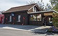
"Musig-Schöpfli" in Birwinken TG

Dorfstrasse 28 in Mattwil

Half-timbered house in Mattwil
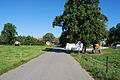
Klarsreuti
_167.JPG)

.jpg)
_192.JPG)
_200.JPG)
Personalities
- Stefan Keller (* 1958 in Birwinken), writer, journalist and historian
Web links and literature
- Official website of the municipality of Birwinken
- Gregor Spuhler : Birwinken. In: Historical Lexicon of Switzerland .
Individual evidence
- ↑ a b Thurgau in figures 2019 . On the website of the Statistical Office of the Canton of Thurgau (PDF file; 1.8 MB), accessed on April 28, 2020.
- ↑ Swiss land use statistics. Completed on July 1, 1912. Published by the Federal Statistical Bureau. ( Memento from April 12, 2016 in the Internet Archive )
- ↑ Permanent and non-permanent resident population by year, canton, district, municipality, population type and gender (permanent resident population). In: bfs. admin.ch . Federal Statistical Office (FSO), August 31, 2019, accessed on December 22, 2019 .
- ↑ a b Eugen Nyffenegger, Oskar Bandle : The settlement names of the canton of Thurgau. 1st half volume: Introduction and historical dictionary of names. Huber, Frauenfeld / Stuttgart / Vienna 2003, ISBN 3-7193-1309-3 , p. 273 f.
- ↑ a b Localities and their resident population. Edition 2019 . On the website of the Statistical Office of the Canton of Thurgau (Excel table; 0.1 MB), accessed on April 28, 2020.
-
↑ a b c d e Gregor Spuhler : Birwinken. In: Historical Lexicon of Switzerland . These sections are largely based on the entry in the Historical Lexicon of Switzerland (HLS), which, according to the HLS's usage information, is under the Creative Commons license - Attribution - Share under the same conditions 4.0 International (CC BY-SA 4.0).
- ↑ a b municipal coat of arms . On the website of the State Archives of the Canton of Thurgau, accessed on December 8, 2019
- ↑ a b Population development of the municipalities. Canton Thurgau, 1850–2000 and resident population of the municipalities and change from the previous year. Canton of Thurgau, 1990–2018. On the website of the Statistical Office of the Canton of Thurgau (Excel tables; 0.1 MB each), accessed on April 28, 2020.
Affeltrangen | Amlikon-Bissegg | Mountain | Birwinken | Bischofszell | Bürglen | Bussnang | Alder | Hauptwil-Gottshaus | Hohentannen | Kradolf-Schönenberg | Märstetten | Schönholzerswilen | Sulgen | Weinfelden | Wigoltingen | Wuppenau | Zihlschlacht-Sitterdorf
Former municipalities: Amlikon | Andhausen | Andwil | Bissegg | Bleiken | Bonau | Book at Märwil | Buchackern | Buhwil | Donzhausen | Engishofen | Engwang | Ennetaach | Friltschen | Götighofen | House of God | Graltshausen | Griesenberg | Guntershausen near Birwinken | Heaps | Happerswil book | Hauptwil | Holy Cross | Heldswil | Hessenreuti | Pants jerk | Illhart | Istighofen | Klarsreuti | Kradolf | Kümmertshausen | Lamperswil | Lanterswil | Leimbach | People mark | Märwil | Mattwil | Mettlen | Neukirch an der Thur | Oberbussnang | Opfershofen | Oppikon | Ottoberg | Reuti | Riedt | Rothenhausen | Schönenberg | Swiss wood | Sitterdorf | Strohwilen | Toos | Weerswilen | Zezikon | Zihlschlacht
Canton of Thurgau |
Districts of the Canton of Thurgau |
Municipalities of the Canton of Thurgau