
Braunau TG
| TG is the abbreviation for the canton of Thurgau in Switzerland and is used to avoid confusion with other entries of the name Braunau . |
| Braunau | |
|---|---|
 |
|
| State : |
|
| Canton : |
|
| District : | Münchwilen |
| BFS no. : | 4723 |
| Postal code : | 9502 |
| Coordinates : | 722 661 / 262 299 |
| Height : | 669 m above sea level M. |
| Height range : | 570–778 m above sea level M. |
| Area : | 9.17 km² |
| Residents: | 778 (December 31, 2018) |
| Population density : | 85 inhabitants per km² |
| Website: | www.braunau.ch |
 View of Braunau |
|
| Location of the municipality | |
  |
|
Braunau , Swiss German Brunau , is a municipality and a town in the district Münchwilen the Swiss canton Thurgau .
The local community Braunau was separated from the municipal community Tobel in 1999 and transformed into the political community Braunau. At the same time, the remaining local communities Tägerschen and Tobel merged to form the political community of Tobel-Tägerschen .
geography
Braunau is located on a small pass in the south of the canton of Thurgau, the so-called Hinterthurgau or Tannzapfenland, embedded between the Braunauer Berg and the Braunauer Höchi . The towns of Beckingen, Hittingen and Oberhausen and 17 hamlets belong to Braunau. To the north of the core community of Braunau, the Hartenauerbach , a tributary of the Leek , flows through the community area from east to west. Towards the south, Braunau is drained by the Wiesentalerbach through the Wiesental towards Bronschhofen .
Braunau lies at an altitude of 669 m above sea level. M. , with the highest point of the municipality at 772 and the lowest at 598 m above sea level. M. lies. The landscape is characterized by tall fruit trees and many hedges.
history
_katolika_kapelo_265.JPG)
Braunau was probably first mentioned in 762 as Pramacunauia . After 762 the area around Braunau belonged to the majority of the manor of the monastery of St. Gallen and came with the judicial rights presumably over the Toggenburg and their servants to Heitnau and from 1228 successively to the Johanniterkomturei Tobel . It was under their rule Tobel until 1798.
Originally Braunau was part of a church after Affeltrangen , but the St. Michaels Chapel belonged to the Märwil parish before 1228 . 1529 Reformation. The remaining Catholics were church-related to Tobel - although there is a chapel in Braunau, the Reformed to Märwil. The church was built from 1806 to 1807. In 1810 Braunau separated from Märwil and in 1861 became a parish with parish voting rights.
The opening in 1519 regulated everyday life in the village. Grain cultivation was carried out in three tents . In the middle of the 19th century there was a switch to cattle and dairy farming with cheese dairies and fruit growing. In the early 19th century, the cotton and linen weaving played a role as domestic industry. a role. The timber construction business with carpentry and sawmill has existed since around 1895.
coat of arms
Blazon : square of yellow and red.
The coat of arms of the former local community and the political community of Braunau was adopted by the Lords of Heitnau, whose castle was in the community area.
population
 |
| year | 1634 | 1850 | 1880 | 1900 | 1930 | 1950 | 1980 | 2000 | 2010 | 2018 |
| Residents | about 300 | 687 | 594 | 550 | 554 | 547 | 459 | 661 | 685 | 778 |
Of the total of 778 inhabitants in the municipality of Braunau in 2018, 77 or 9.9% were foreign nationals. 294 (37.8%) were Protestant Reformed and 285 (36.6%) were Roman Catholic. In 2010 there were 685 inhabitants in 267 households. 33 people worked as farmers.
economy
In 2016 Braunau offered work for 181 people (converted to full-time positions). Of these, 34.8% were employed in agriculture and forestry, 16.1% in industry, trade and construction and 49.1% in the service sector.
The community of Braunau is characterized by the many farms. Because of the altitude and the climate, arable farming is only possible to a limited extent. Fruit growing with tall apple, pear, plum and cherry trees are of certain importance.
Attractions
The construction of the Catholic Chapel of St. Michael is believed to have been in the 13th or 14th century due to the bells. The reformed church came into being in 1806/07. The landmark is an oak tree that is over 300 years old and stands in Ueterschen on the edge of the forest.
photos

Protestant church

Evangelical Church from the inside

Oberhausen
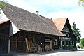
Half-timbered house in Braunau

Parish hall

school

_evangelia_preghejo_de_interne_252.JPG)
_235.JPG)
_faktrabdomo_262.JPG)
_komunuma_domo_249.JPG)
_lernejo_242.JPG)

Web links
Individual evidence
- ↑ Permanent and non-permanent resident population by year, canton, district, municipality, population type and gender (permanent resident population). In: bfs. admin.ch . Federal Statistical Office (FSO), August 31, 2019, accessed on December 22, 2019 .
- ↑ a b Thurgau in figures 2019 . On the website of the Statistical Office of the Canton of Thurgau (PDF file; 1.8 MB), accessed on April 28, 2020.
- ↑ Braunau on ortsnames.ch (online database), accessed on February 15, 2020
- ↑ a b Localities and their resident population. Edition 2019 . On the website of the Statistical Office of the Canton of Thurgau (Excel table; 0.1 MB), accessed on April 28, 2020.
- ↑ a b c population development of the municipalities. Canton Thurgau, 1850–2000 and resident population of the municipalities and change from the previous year. Canton of Thurgau, 1990–2018. On the website of the Statistical Office of the Canton of Thurgau (Excel tables; 0.1 MB each), accessed on April 28, 2020.
-
↑ a b c Location information board in the village center of Braunau TG , photographed on April 23, 2020
- ↑ Braunau late Romanesque chapel. From: freizeit.thurbo.ch, a website of the Thurbo railway company , accessed on November 1, 2019
-
^ A b c André Salathé: Braunau. In: Historical Lexicon of Switzerland .
These sections are largely based on the entry in the Historical Lexicon of Switzerland (HLS), which, according to the HLS's usage information, is under the Creative Commons license - Attribution - Share under the same conditions 4.0 International (CC BY-SA 4.0). - ↑ a b municipal coat of arms . On the website of the State Archives of the Canton of Thurgau, accessed on December 8, 2019
- ↑ Politische Gemeinde Braunau ( Memento of March 4, 2016 in the Internet Archive ) (PDF; 73 kB), www.braunau.ch, accessed on June 8, 2011
Aadorf | Bed meadows | Bichelsee-Balterswil | Braunau | Eschlikon | Fischingen | Lommis | Münchwilen | Rickenbach | Sirnach | Tobel-Tägerschen | Wängi | Wilen
Former communities: Aawangen | Anetswil | Au | Balterswil | Bichelsee | Busswil | Dussnang | Ettenhausen | Guntershausen | Hofen | Holzmannshaus | Horben | Cold houses | Krillberg | Littenheid | Oberhofen near Münchwilen | Oberwangen | St. Margarethen | Tagerschen | Tannegg | Tobel | Tuttwil | Wallenwil | Vineyard | Wiezikon | Wittenwil
Canton of Thurgau | Districts of the Canton of Thurgau | Municipalities of the Canton of Thurgau