
Wittenwil
| Wittenwil | ||
|---|---|---|
 |
||
| State : |
|
|
| Canton : |
|
|
| District : | Münchwilen | |
| Political community : | Aadorf | |
| Postal code : | 8355 | |
| former BFS no. : | 4555 | |
| Coordinates : | 711 835 / 262 630 | |
| Height : | 503 m above sea level M. | |
| Area : | 4.50 km² | |
| Residents: | 456 (December 31, 2018) | |
| Population density : | 101 inhabitants per km² | |
| Website: | www.wittenwilweiern.ch/wxpz/ | |
 Wittenwil |
||
| map | ||
|
||


Wittenwil is a former municipality and a village in the municipality of Aadorf in the Münchwilen district of the canton of Thurgau in Switzerland , between Murg and Lützelmurg .
From 1803 to 1995 the local community of Wittenwil, which from 1812 also included Weiern, Heiterschen and Tausendlist, was part of the municipal community of Aadorf. On January 1, 1996 , the Wittenwil community merged to form the political community of Aadorf. At the same time, the Heiterschen and Jakobstal were separated from the local community of Wittenwil and assigned to the unitary community of Wängi .
history
The place was first mentioned in 1282 as Witenwile . In the Middle Ages, Wittenwil belonged to the Counts of Toggenburg , who merged it with Spiegelberg to form one rule in 1376 . The Muntprat von Spiegelberg owned this rule from 1464, the von Landenberg from 1528. Wittenwil and Spiegelberg were separated again in 1595. From 1620 the Harders, who rebuilt the castle in 1656, were the court lords of Wittenwil, from 1722 to 1774 the barons of Rüpplin and from 1777 to 1798 the Schulthess family from Zurich. Ecclesiastically, Wittenwil shared the fate of Aadorf.
In addition to arable, meadow and fruit growing, cattle and dairy farming was practiced from 1850, and a cheese dairy was established in 1882. From 1880 to 1927 there was an embroidery and from 1850 to 1927 there was a cotton weaving mill in Jakobstal. After connecting to the A1 motorway , the population rose steadily from 1970 onwards.
population
| year | 1850 | 1900 | 1950 | 1990 | 2000 | 2010 | 2018 |
|---|---|---|---|---|---|---|---|
| Local parish | 411 | 440 | 487 | 573 | |||
| Locality | 273 | 287 | 456 | ||||
| source | |||||||
Of the total of 456 inhabitants of the village of Wittenwil in 2018, 219 (48.0%) were Protestant Reformed and 109 (23.9%) were Roman Catholic.
Attractions
Wittenwil Castle and the former “Zum Tannenbaum” inn in Weiern are included in the list of cultural assets in Aadorf .

Wittenwil Castle, south side

Wittenwil Castle, west side
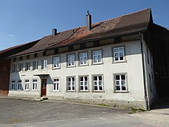
“Zum Tannenbaum” pub in Weiern


literature
- Erich Trösch: Wittenwil. In: Historical Lexicon of Switzerland .
This article is largely based on the entry in the Historisches Lexikon der Schweiz (HLS), which, according to the HLS's usage information, is licensed under the Creative Commons - Attribution - Distribution under the same conditions 4.0 International (CC BY-SA 4.0) license .
Web links
- Wittenwil Weiern. Website of the Wittenwil Weiern village association
Individual evidence
- ↑ Swiss land use statistics. Completed on July 1, 1912. Published by the Federal Statistical Bureau. ( Memento from April 12, 2016 in the Internet Archive )
- ↑ a b c d Localities and their resident population. Edition 2019 . On the website of the Statistical Office of the Canton of Thurgau (Excel table; 0.1 MB), accessed on April 28, 2020.
- ↑ Locations and Settlements Directory. Canton of Thurgau, 2005 edition . On the website of the Statistical Office of the Canton of Thurgau (PDF; 1.7 MB), accessed on April 28, 2020.
- ↑ Locations and Settlements Directory. Canton of Thurgau, 2012 edition. On the website of the Statistical Office of the Canton of Thurgau (PDF; 3.4 MB), accessed on May 11, 2020.
Remarks
- ↑ with outside courtyards
Aadorf | Bed meadows | Bichelsee-Balterswil | Braunau | Eschlikon | Fischingen | Lommis | Münchwilen | Rickenbach | Sirnach | Tobel-Tägerschen | Wängi | Wilen
Former communities: Aawangen | Anetswil | Au | Balterswil | Bichelsee | Busswil | Dussnang | Ettenhausen | Guntershausen | Hofen | Holzmannshaus | Horben | Cold houses | Krillberg | Littenheid | Oberhofen near Münchwilen | Oberwangen | St. Margarethen | Tagerschen | Tannegg | Tobel | Tuttwil | Wallenwil | Vineyard | Wiezikon | Wittenwil
Canton of Thurgau | Districts of the Canton of Thurgau | Municipalities of the Canton of Thurgau