
Anetswil
| Anetswil | ||
|---|---|---|
 |
||
| State : |
|
|
| Canton : |
|
|
| District : | Münchwilen | |
| Political community : | Wängi | |
| Postal code : | 9545 | |
| former BFS no. : | 4781 | |
| Coordinates : | 715 770 / 262 928 | |
| Height : | 534 m above sea level M. | |
| Area : | 4.36 km² | |
| Residents: | 465 (1960) | |
| Population density : | 107 inhabitants per km² | |
 Anetswil |
||
| map | ||
|
||


Anetswil is a settlement in the political municipality of Wängi in the Münchwilen district of the canton of Thurgau in Switzerland .
On January 1, 1969, the local community of Anetswil , which existed from 1812, was part of the Wängi community .
geography
Anetswil is located on a flat range of hills northeast of Wängi.
history
Anetswil was mentioned in 904 as Adelnoteswilare and in 1303 as Arnoltswile . The farm in Anetswil was a fiefdom of Eberhard von Klingenberg in 1489 . The monastery of St. Gallen is documented as the landlord for the Eggetsbühl farm in 1428, and the Fischingen monastery for the Berg farm in 1580 . Anetswil belonged to the so-called High Court on Tuttwilerberg and was consequently subordinate to the Landvogt or his subordinate in Hofen near Sirnach in lower court cases . Church-wise, Anetswil has always been part of Wängi.
The village used to be on the road from Frauenfeld to Wil , but this was moved to the valley in 1842. Agriculture was the main industry.
population
| year | 1831 | 1900 | 1910 | 1960 | 2010 | 2018 |
| Local parish | 391 | 352 | 427 | 465 | ||
| settlement | 52 | 71 | ||||
| source | ||||||
photos

Anetswil during the apple blossom
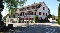
Restaurant happiness


source
-
Gregor Spuhler : Anetswil. In: Historical Lexicon of Switzerland .
This article is largely based on the entry in the Historisches Lexikon der Schweiz (HLS), which, according to the HLS's usage information, is licensed under the Creative Commons - Attribution - Distribution under the same conditions 4.0 International (CC BY-SA 4.0) license .
Individual evidence
- ↑ Swiss land use statistics. Completed on July 1, 1912. Published by the Federal Statistical Bureau. ( Memento from April 12, 2016 in the Internet Archive )
- ^ Gregor Spuhler : Anetswil. In: Historical Lexicon of Switzerland .
- ↑ a b List of localities and settlements. Canton of Thurgau, 2012 edition. On the website of the Statistical Office of the Canton of Thurgau (PDF; 3.4 MB), accessed on May 11, 2020.
- ↑ StiASG , Urk. IV 443. Online at e-chartae , accessed on June 12, 2020.
- ↑ List of settlements. Canton of Thurgau, edition 2019 . On the website of the Statistical Office of the Canton of Thurgau (Excel table; 0.2 MB), accessed on May 10, 2020.
Aadorf | Bed meadows | Bichelsee-Balterswil | Braunau | Eschlikon | Fischingen | Lommis | Münchwilen | Rickenbach | Sirnach | Tobel-Tägerschen | Wängi | Wilen
Former communities: Aawangen | Anetswil | Au | Balterswil | Bichelsee | Busswil | Dussnang | Ettenhausen | Guntershausen | Hofen | Holzmannshaus | Horben | Cold houses | Krillberg | Littenheid | Oberhofen near Münchwilen | Oberwangen | St. Margarethen | Tagerschen | Tannegg | Tobel | Tuttwil | Wallenwil | Vineyard | Wiezikon | Wittenwil
Canton of Thurgau | Districts of the Canton of Thurgau | Municipalities of the Canton of Thurgau