
Wilen TG
| TG is the abbreviation for the canton of Thurgau in Switzerland and is used to avoid confusion with other entries of the name Wilen . |
| Wilen | |
|---|---|
 |
|
| State : |
|
| Canton : |
|
| District : | Münchwilen |
| BFS no. : | 4786 |
| Postal code : | 9535 |
| Coordinates : | 720 263 / 256690 |
| Height : | 552 m above sea level M. |
| Height range : | 554–683 m above sea level M. |
| Area : | 2.25 km² |
| Residents: | 2521 (December 31, 2018) |
| Population density : | 1120 inhabitants per km² |
| Website: | www.wilen.ch |
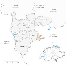
| Location of the municipality | |
 _2011.png) |
|
Wilen is a municipality and a town in the district Münchwilen the Swiss canton Thurgau .
Until December 31, 1997 Wilen belonged as a local community Wilen bei Wil to the municipal community Rickenbach bei Wil . At the beginning of 1998, Wilen was separated from Rickenbach bei Wil as part of the Thurgau community reform and converted into the political community of Wilen (TG) .
geography
Wilen is located about 3 km south of Wil on the north-eastern slope of the Hummelberg. With a total area of 225 hectares, Wilen is one of the smaller communities in Hinterthurgau . Despite its proximity to the more urban Wilen, Wilen is a rural village.
history
The community was first mentioned in 1302 as a hamlet of the city of Wil , at that time it was still called Wiler . Wilen was under the fürstäbtisch-the St. Gallen court Rickenbach, the 1471 to 1798 from the farm to Wil was administered the monastery of St. Gallen. The Catholics of Wilen always belonged to the parish church of Wil. The Reformed attended the service in Sirnach and in 1889 moved to the newly founded parish of Wil. Schoolhouses were built in 1833, 1897 and 1969.
In 1807, general grazing was abolished. Embroidery in particular was widespread as a home industry between 1880 and around 1920. After that, many residents found their earnings in the industrial plants of Wil. From 1950 onwards, single and multi-family houses were built in the community. In 1998 the current political community was founded. In 2003 Wilen received its own cemetery and in 2004 an ecumenical church and community center.
It is unclear whether Wilen was already mentioned in the Henauer deed in 754 . It is generally assumed that the neighboring town of Wil was meant there, but it cannot be ruled out that it could be Wilen.
coat of arms
Blazon : split from red with yellow lion and white with black key .
The coat of arms refers to the previous legal situation of the municipality. The lion of the old Thurgau coat of arms indicates the affiliation to the Landgraviate of Thurgau , the key refers to the connection to the Church of St. Peter in Wil.
population
 |
| 1850 | 1880 | 1900 | 1930 | 1950 | 1960 | 1970 | 1980 | 1990 | 2000 | 2010 | 2018 | |
| Local parish | 292 | 345 | 379 | 609 | 640 | 950 | 1196 | 1049 | 1502 | |||
| Political community | 1760 | 2076 | 2512 | |||||||||
Of the total of 2512 inhabitants of the village of Wilen (political municipality) in 2018, 315 or 12.5% were foreign nationals. 1259 (50.1%) were Roman Catholic and 589 (23.4%) were Protestant Reformed.
Economy and Transport
In 2016, Wilen offered 403 jobs (converted to full-time positions). 1.7% of these were employed in agriculture and forestry, 24.6% in industry, trade and construction and 73.8% in the service sector.
In terms of traffic, Wilen benefits from its proximity to Wil . The connection to the A1 in Wil can be reached in 5 minutes. The Wil – Wilen bus line has existed since 1981, so the Wil train station can be reached in a few minutes. There is no through traffic in the village. The cantonal road from Sirnach to Rickenbach , which leads past the village, is the only traffic axis.
Culture, education
The first schoolhouse in Wilen was built in 1833. The oldest schoolhouse still in use is the "Türmlischulhaus". It was built in 1897. It owes its name to the small tower-like structure that contains a small bell. Today the kindergarten is housed in the building. The primary school building including the gym was built in 1954 and has been expanded twice since then (1968 and 1989). In 1994, the secondary school center Ägelsee was opened in Wilen, which is attended by students from Wilen, Rickenbach and Busswil .
Churches
Wilen is one of the parishes of Wil . However, since 2004 there has been an ecumenical church and community center in Wilen , which is financed and used jointly by the Protestant and Catholic communities. It was created by converting the multi-purpose building, in which Catholic services had already taken place.
photos

.jpg)

Web links
- Official website of the municipality of Wilen TG
- Information about the church and community center in Wilen
Individual evidence
- ↑ Permanent and non-permanent resident population by year, canton, district, municipality, population type and gender (permanent resident population). In: bfs. admin.ch . Federal Statistical Office (FSO), August 31, 2019, accessed on December 22, 2019 .
- ↑ a b Thurgau in figures 2019 . On the website of the Statistical Office of the Canton of Thurgau (PDF file; 1.8 MB), accessed on April 28, 2020.
- ↑ a b Localities and their resident population. Edition 2019 . On the website of the Statistical Office of the Canton of Thurgau (Excel table; 0.1 MB), accessed on April 28, 2020.
-
↑ Erich Trösch: Wilen (TG). In: Historical Lexicon of Switzerland .
These sections are largely based on the entry in the Historical Lexicon of Switzerland (HLS), which, according to the HLS's usage information, is under the Creative Commons license - Attribution - Share under the same conditions 4.0 International (CC BY-SA 4.0). - ↑ a b municipal coat of arms . On the website of the State Archives of the Canton of Thurgau, accessed on December 8, 2019
- ↑ a b Population development of the municipalities. Canton Thurgau, 1850–2000 and resident population of the municipalities and change from the previous year. Canton of Thurgau, 1990–2018. On the website of the Statistical Office of the Canton of Thurgau (Excel tables; 0.1 MB each), accessed on April 28, 2020.
Aadorf | Bed meadows | Bichelsee-Balterswil | Braunau | Eschlikon | Fischingen | Lommis | Münchwilen | Rickenbach | Sirnach | Tobel-Tägerschen | Wängi | Wilen
Former communities: Aawangen | Anetswil | Au | Balterswil | Bichelsee | Busswil | Dussnang | Ettenhausen | Guntershausen | Hofen | Holzmannshaus | Horben | Cold houses | Krillberg | Littenheid | Oberhofen near Münchwilen | Oberwangen | St. Margarethen | Tagerschen | Tannegg | Tobel | Tuttwil | Wallenwil | Vineyard | Wiezikon | Wittenwil
Canton of Thurgau | Districts of the Canton of Thurgau | Municipalities of the Canton of Thurgau