
Münchwilen TG
| TG is the abbreviation for the canton of Thurgau in Switzerland and is used to avoid confusion with other entries of the name Münchwilen . |
| Münchwilen | |
|---|---|
 |
|
| State : |
|
| Canton : |
|
| District : | Münchwilen |
| BFS no. : | 4746 |
| Postal code : | 9542 |
| UN / LOCODE : | CH MWI |
| Coordinates : | 716 419 / 260 320 |
| Height : | 515 m above sea level M. |
| Height range : | 489–632 m above sea level M. |
| Area : | 7.81 km² |
| Residents: | 5624 (December 31, 2018) |
| Population density : | 720 inhabitants per km² |
| Website: | www.muenchwilen-tg.ch |
 Münchwilen TG |
|
| Location of the municipality | |
  |
|
Münchwilen is a political municipality and the capital of the district of the same name in the Swiss canton of Thurgau .
geography
Münchwilen is located in Hinterthurgau , forms a kind of agglomeration with Sirnach and is about four kilometers west of the St. Gallen town of Wil . The Murg flows through Münchwilen.
The community includes Münchwilen and St. Margarethen as well as the hamlets of Freudenberg, Holzmannshaus , Mezikon, Mörikon, Pfannenstil, Sedel and Sigensee. Today Oberhofen bei Münchwilen is a district of Münchwilen.
history

Property of the St. Gallen monastery in Münchwilen is documented for 1160 and 1170 . From the late 15th century to 1798, Münchwilen belonged to the so-called high court on Tuttwilerberg , in which the federal governor or his governor at court held the high and lower courts . Oberhofen and Sigensee belonged to the Tannegg domain . Ecclesiastically announced Münchwilen to the founding of the Protestant parish Münchwilen- Eschlikon 1935 - Oberhofen , St. Margaret and Wallenwil belonged - the fate of the parish Sirnach , the first to the Reformation passed, then an equal number was. In 1937 a reformed church was built , and in 1968 the Catholic Church of St. Anthony was built.

In 1601 a mill is mentioned that used the water power of the Murg . The construction of the Murg Bridge to Oberhofen in 1774 and the construction of the Wil - Winterthur road in 1785 provided the basis for the development of (hospitality) trade and the factory industry. The cotton weaving mill Heitz with a branch in St. Margarethen and the spinning mill Zellweger emerged from a cotton spinning mill founded in 1817 . In 1866 the company Wäffler-Egli operated 5228 spindles and J. Heitz & Cie. employed about a thousand home weavers. In 1871 the regional industrial center Münchwilen became the district capital instead of Tobel . Presumably, the opening of the Frauenfeld-Wil railway in 1887 favored the strong growth around 1900. Trade and industry are located in the town center, for example the manufacturer of cleaning products Diversey , founded in 1858 as Sutter vinegar factory , Swisstulle AG (since 1913, until 2002 as a Swiss company for Tulle industry ) and the lamp and metal goods factory Huco AG (since 1927). In 1969 Münchwilen was connected to the A1 motorway .
From 1803 to 1950 formed Münchwilen a local congregation of Munizipalgemeinde Sirnach. In a process that lasted from 1812 to 1824, Münchwilen merged with the municipality of Mezikon. In 1950 the local communities Münchwilen, Oberhofen and St. Margarethen merged to form the unified community Münchwilen against the resistance of the other local communities belonging to the municipality of Sirnach .
→ see also the history sections in the articles Holzmannshaus , Oberhofen bei Münchwilen and St. Margarethen TG
coat of arms
Blazon : In blue a white pole topped with three five-pointed stars .
The coat of arms goes back to the Lords of Münchwilen, but has been supplemented by three stars, which stand for the former local communities Münchwilen, Oberhofen and St. Margarethen.
population
 |
| 1850 | 1900 | 1941 | 1950 | 1970 | 1980 | 2000 | 2010 | 2018 | |
|---|---|---|---|---|---|---|---|---|---|
| Political community | 2540 | 3252 | 3172 | 4553 | 4765 | 5607 | |||
| Local parish | 400 | 585 | 1046 | ||||||
| source | |||||||||
Of the total of 5,607 inhabitants of the Münchwilen municipality in 2018, 1,166 or 20.8% were foreign nationals. 27.0% (2222) were Roman Catholic and 5607 (1516) were Protestant Reformed. At that time, Münchwilen had 4480 residents.
economy
In 2016 Münchwilen offered work for 1906 people (converted to full-time positions). 2.3% of these were employed in agriculture and forestry, 46.0% in industry, trade and construction and 51.7% in the service sector.
traffic
Münchwilen is made accessible to public transport by the Frauenfeld-Wil-Bahn . The main road through Münchwilen runs parallel to the railway line from Wil to Frauenfeld . The village is also on the A1 motorway and has its own exit.
Attractions
photos
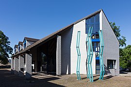
Parish hall

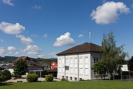
Court house

Ref. Church

School center Oberhofen


Secondary school Waldegg
Kastanienhof schoolhouse

chapel

Wilerstrasse

Residential quarter on Rütistrasse


Personalities
- Yves Rüedi (* 1976), federal judge
- Robert Thomann (1873–1958), civil engineer
Web links
Individual evidence
- ↑ Permanent and non-permanent resident population by year, canton, district, municipality, population type and gender (permanent resident population). In: bfs. admin.ch . Federal Statistical Office (FSO), August 31, 2019, accessed on December 22, 2019 .
- ↑ a b Thurgau in figures 2019 . On the website of the Statistical Office of the Canton of Thurgau (PDF file; 1.8 MB), accessed on April 28, 2020.
- ↑ Swiss land use statistics. Completed on July 1, 1912. Published by the Federal Statistical Bureau. ( Memento from April 12, 2016 in the Internet Archive )
- ↑ a b Localities and their resident population. Edition 2019 . On the website of the Statistical Office of the Canton of Thurgau (Excel table; 0.1 MB), accessed on April 28, 2020.
-
↑ a b Gregor Spuhler : Münchwilen (TG). In: Historical Lexicon of Switzerland .
These sections are largely based on the entry in the Historical Lexicon of Switzerland (HLS), which, according to the HLS's usage information, is under the Creative Commons license - Attribution - Share under the same conditions 4.0 International (CC BY-SA 4.0). - ↑ a b municipal coat of arms . On the website of the State Archives of the Canton of Thurgau, accessed on December 8, 2019
- ↑ a b Population development of the municipalities. Canton Thurgau, 1850–2000 and resident population of the municipalities and change from the previous year. Canton of Thurgau, 1990–2018. On the website of the Statistical Office of the Canton of Thurgau (Excel tables; 0.1 MB each), accessed on April 28, 2020.
← Previous location: St. Margarethen TG | Münchwilen TG | Next town: Sirnach →
Aadorf | Bed meadows | Bichelsee-Balterswil | Braunau | Eschlikon | Fischingen | Lommis | Münchwilen | Rickenbach | Sirnach | Tobel-Tägerschen | Wängi | Wilen
Former communities: Aawangen | Anetswil | Au | Balterswil | Bichelsee | Busswil | Dussnang | Ettenhausen | Guntershausen | Hofen | Holzmannshaus | Horben | Cold houses | Krillberg | Littenheid | Oberhofen near Münchwilen | Oberwangen | St. Margarethen | Tagerschen | Tannegg | Tobel | Tuttwil | Wallenwil | Vineyard | Wiezikon | Wittenwil
Canton of Thurgau | Districts of the Canton of Thurgau | Municipalities of the Canton of Thurgau