
Obstacles
| Obstacles | ||
|---|---|---|
| State : |
|
|
| Canton : |
|
|
| District : | Yards | |
| Municipality : | Freienbach | |
| Postal code : | 8640 | |
| Coordinates : | 703 325 / 230126 | |
| Height : | 408 m above sea level M. | |
| Residents: | 271 (December 31, 2008) | |
| Website: | www.freibach.ch | |
 View from the Etzel |
||
| map | ||
|
||


Hurden is a district of the Swiss municipality of Freienbach . The 1.31 km² district with posh villas and gourmet restaurants is located on an island in Lake Zurich on the Rapperswil Seedamm between Pfäffikon SZ and Rapperswil SG and is closely linked to the history of the Seedamm.
Emergence
The headland, which protrudes far into Lake Zurich, has its origin in a landfill of a Worm Ice Age retreat of the Linth Glacier . This retreat left behind a moraine which separates Lake Zurich into two parts, the Obersee and the actual Lake Zurich. Over time, the Rapperswil Seedamm was built on this narrow lake with additional light embankments and the construction of a bridge.
history
Hurden was already used as a transshipment point in Roman times. In the 9th century, a ferry service from Kempraten to Hurden was set up across the narrow lake and, thanks to the onset of pilgrims from southern Germany, brought a lot of traffic to Einsiedeln Monastery . The name "de Hurden" appears for the peninsula for the first time in 1217 and was given this because of the many fish traps made of woven work, the hurdles or hurdles that were set up here by the locals.
Between 1358 and 1360, Duke Rudolf IV of Habsburg built an 1850-step wooden bridge that connected the city of Rapperswil with the Hurden peninsula. Now the locals and pilgrims were no longer dependent on the ferry service, but could get to the other side of the lake at any time with carts and cattle. A road toll had to be paid for the maintenance of the bridge .
Around the year 1430 a wooden bridge also led from Hurden over to the island of Ufenau , which was known as the "Kilchweg in die Uffnow". In 1440 the village of Hurden became part of Schwyz and in 1443 it was set on fire together with the bridge to Ufenau by the Austrian people of Rapperswil (→ Battle of Freienbach ). As a result of the Second Villmerger War , Hurden fell to Zurich , Bern and Glarus and the governor of Wädenswil was entrusted with the administration of Hurden.
In 1798, Hurden came politically to the Rapperswil district in the canton of Linth and in 1803 to the newly created Pfäffikon . During the turmoil of the revolution , the wooden footbridge to Rapperswil was destroyed several times and rebuilt again and again.
In 1875 a permanent lake dam was built with road and rails for the Lake Zurich – Gotthard Railway , which could be opened to traffic three years later. The headland of Hurden was used as a welcome building plot for weekend houses from 1930 , and permanent detached houses were also built from 1950.
1943, a channel is in the southern Hurden puncture dredged from the upper to the lower Zurich and the road and train it out by means of a bridge. Now the Obersee was also navigable for the ships of the Zürichsee Schifffahrtsgesellschaft (ZSG), but the Hurden peninsula actually became a real island, which is cut off from the mainland. From 1990 onwards, Hurden became popular for luxury villas, some of which were built on freshly filled areas and equipped with their own yacht berth .
On the initiative of various organizations and personalities, the construction of a new wooden footbridge between Rapperswil and Hurden began in 2000 , which crosses the narrow lake as a footpath and hiking trail at points of the previous bridges and is intended to be a reminder of this. On April 6, 2001 the 841 meter long wooden bridge, the longest wooden bridge in Switzerland, was opened to pedestrians and is very popular with walkers.

Hurden and the rule of Rapperswil on the Murer map of 1566

Fishermen and their hurdles ( fish traps ), view from Obersee near Hurden to the wooden bridge , the town of Rapperswil in the background, on an engraving by J. Barbier, around 1780

View from Pfäffikon over the upper Lake Zurich towards Rapperswil , below the center of the picture is Hurden

Same view in 1929, photo by
Walter Mittelholzer
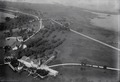
Historic aerial photo from July 5, 1933, taken by Walter Mittelholzer
Historic aerial photo from 1924, taken from a height of 200 meters by Walter Mittelholzer

Historic aerial photo from 1924, taken from a height of 300 meters by Walter Mittelholzer

View of the Seedamm and Hurden from the Lindenhof in Rapperswil


UNESCO World Heritage Site and Cultural Property of National Importance
Together with the sites Rapperswil-Jona-Technikum , Seegubel and the lake crossings between Rapperswil and Hurden , the prehistoric remains of the Freienbach – Hurden – Rosshorn settlements were added to the UNESCO World Heritage List on June 27, 2011 as part of the lakeside settlements in the Alpine region .
traffic
The place is well connected to the road network thanks to the main road over the lake dam. The village also has the Hurden stop on the Pfäffikon-Rapperswil railway line and is well integrated into the public transport network thanks to the S-Bahn of the Zurich Transport Association and the connections of the Swiss Southeast Railway (SOB).
literature
- Anja Buschow Oechslin: The art monuments of the canton Schwytz. Schwyz IV. District Höfe. Edited by the Society for Swiss Art History GSK. Bern 2010 (Art Monuments of Switzerland Volume 118). ISBN 978-3-906131-93-1 .
Web links
- Paul Wyrsch: Hurdles. In: Historical Lexicon of Switzerland .
- The story of Hurden on pfaeffikon.uch.ch
- Hurden on the website of the municipality of Freienbach; under portrait, five villages
Individual evidence
- ↑ Website palafittes.org: Swiss sites in the UNESCO World Heritage Site ( Memento of the original dated May 31, 2016 in the Internet Archive ) Info: The archive link was inserted automatically and has not yet been checked. Please check the original and archive link according to the instructions and then remove this notice. : Rapperswil / Hombrechtikon field Bach (CH-SG-01), Rapperswil-pilot (CH-SG-02), freienbach-hurden rosshorn (CH SZ-01) together with the prehistoric and historic Seequerungen accessed, on February 15, 2013
← Previous location: Wooden footbridge over Lake Zurich | Hurdles | Next town: Pfäffikon SZ →
