
Forest ZH
| ZH is the abbreviation for the Canton of Zurich in Switzerland and is used to avoid confusion with other entries of the name Wald . |
| Forest | |
|---|---|
 |
|
| State : |
|
| Canton : |
|
| District : | Hinwil |
| BFS no. : | 0120 |
| Postal code : | 8636 Wald ZH 8637 Laupen ZH 8639 Faltigberg |
| UN / LOCODE : | CH WLD |
| Coordinates : | 711 663 / 237123 |
| Height : | 619 m above sea level M. |
| Height range : | 559–1243 m above sea level M. |
| Area : | 25.27 km² |
| Residents: | 9949 (December 31, 2018) |
| Population density : | 394 inhabitants per km² |
|
Proportion of foreigners : (residents without citizenship ) |
26.4% (December 31, 2018) |
| Website: | www.wald-zh.ch |
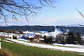
 View from Vorderwald to the west towards the town center (in the background Lake Zurich and the Albis ) |
|
| Location of the municipality | |
  |
|
Wald is a municipality in the district of Hinwil in the Swiss canton of Zurich .
geography
Wald (formerly also Wald an der Jona or Wald an der Jonen ) is located in the Zurich Oberland , in the upper Jona valley , the cut between Scheidegg , Batzberg and Bachtel . Neighboring communities of Wald are Fischenthal in the north, Hinwil , Dürnten and Rüti in the west and Eschenbach ( Canton St. Gallen ) in the east and south.
Of the total area of 25.28 km 2 , 51.5% is agricultural area, 29.4% forest, 13.3% settlement area, 4.1% traffic area and 1.1% water area.
topography
The highest point in the community is at Brandegg at 1243 m above sea level. M. , the deepest at the Grundtal at 565 m above sea level. M. The watershed between Töss- and Jonatal a few meters north of the municipality boundary, in Gibswil (Fischenthal), at 757 m above sea level. M. In the municipal area of Wald, the Jona overcomes a gradient of 180 m before it forms the municipal boundary to Rüti ZH from Tüfentobel . In the north-east, the municipality of Wald also includes part of the upper reaches of the Töss (Vordertöss, to Tössscheidi).
Heights within the municipality are: Brandegg / Überzütt ( 1246 m above sea level ) with Dürrspitz ( 1202 m above sea level ), Oberegg ( 1107 m above sea level ) and Josenberg ( 1085 m above sea level ); Bachtelhörnli ( 968 m above sea level ); Chrattenholz ( 934 m above sea level ) and Förbüül ( 857 m above sea level , with a presumed castle site); Haltberg ( 807 m above sea level ). The peaks of Hüttchopf ( 1231 m above sea level ), Tössstock ( 1153 m above sea level ) and Auenberg ( 1050 m above sea level ) lie on the municipal boundary . The peaks of the Bachtel (Hinwil) and Batzberg (Rüti) are just outside the municipal boundaries.
Outside guards
The municipality includes the villages of Wald and Laupen , as well as around 125 hamlets and individual farms. The term outer guard (Ussewacht) is a specific in the Zurich Oberland common term for Weiler , who (as opposed to civil communities have) no autonomy and administratively a mother church are assigned.
In the 18th and 19th centuries the community was divided into six guard districts (later also school communities), in addition to Wald and Laupen, Güntisberg, Ried, Hübli and Hittenberg.
Historically, Laupen is not regarded as an outside watch in the forest, but as an independent village. In the 19th century it formed its own civil parish .
Ried , the northernmost watch, lies on a terminal moraine of the last glaciation, which forms the watershed between Töss and Jona. Ried was densely populated early on, as the pilgrimage route to Einsiedeln leads past there.
Hittenberg , a cross-country road around 900 meters above sea level, is the smallest forest watch in terms of population. This is where the Zürcher Höhenklinik Wald (Zurich Rehabilitation Center since 2015) is located, the former sanatorium for lung patients.
Güntisberg -Mettlen is located on the Batzberg , which delimits the forest to the southwest. There are many stately farms here that make use of the topographical and climatic conditions.
Hüebli towers over the Sagenraintobel. The hamlet includes many farmsteads that are located between Hischwil and Fälmis (from Fäldmoos, from Middle High German mos / mies "swamp, moor" and feld ) on the steep slope of the Scheidegg .
Blattenbach , which does not have its own school, is historically significant with the Rickenbach farm (first mentioned around 820) and the pilgrim hostel for the red sword (built in 1530).
The following list of the outer guards, courtyards and districts of Wald is arranged according to the six historical guard districts:
- Forest: Bartstock, Blatten, Brüglen, Elba, Grütacker, Haltberg, Haselstaud, Hefern, Kühweid, Langboden, Lindenhof, Mettlen, Mählenrüti, Neuholz, Oberwies, Oberhaltberg, Riedtwies, Sagenrain, Spittel, Schlipf, Steig, Steigewid, Strickenberg, Stuck, Tobel, Tonacker, Unterbund, Borderwaid, Windegg , Blattenbach, Bachtel, Boden, Binzholz, Dieterswil, DÄNDER, Feld, Finsterbach, Ferracker, Grund, Haberrüti, Halden, HinterdÄNDER, Hirschlen, Oberfeld, Rickenbach, Scheuerli, Stockenmatt, Vorhalden, Weissgass.
- Laupen : Altweid, Au, am Bach, Bär, Bebikon, Diezikon, Hinternord, Hubwies, Kefa, Morgen, Narren, Neuhaus, Oberdienberg, Oberlaupen, Töbeli, Windlen, Winkel.
- Güntisberg : Batzenberg, Dachsegg, Gart, Hagenacher, Hiltisberg (Hilisberg), Mettlen, Schänke (Schebi), Weyen (Grossweiher), Wiederriet (Widenriet).
- Ried: Aatal, Blackbirds, Beizi, Breiten, Bühl, Chloster, Ebnat, Grosswies, Hinterberg, Hubhausen, Loch, Nasen, Oberbühl, Oberegg, Raad, Rüti, Scheuerli, Sennenberg, Tanneck, Überzütt, Vorderberg.
- Hüebli: Aa, Boden, Fälmis (Felmis), Gheist, Haltbergholz, Hessen, Hintererli (Ehrlen), Hinterwald, Hirschacker, Hischwil, Hundsruggen (dog's back), Luget, Scheidegg , Steingass, Steinweid, Tief, Vordererli (Vorder-Ehrlen), Zelg.
- Hittenberg: Chrinnen (Krinnen), Niederholz.
history
middle Ages

From the 8th century onwards, the area, which was not or barely populated, was on the border between the counties of Zürichgau and Thurgau . The old road from Konstanz to Einsiedeln followed the Töss valley and then ran to the right of the Jona. The Alemannic settlement of the upper Jonatal begins in the 9th century as a scattered settlement of individual farms. The farms of Rickenbach (around 819/820: Richinbach ) near Blattenbach ( 710 m above sea level ) are the earliest records .
The settlement core of Wald was formed to the left of the Jona, at the tributary known today as Schmittenbach . The parish church is mentioned for the first time in 1208, together with the name of origin de Walde ( Corrado decano de Walde, "Konrad, deacon of forest"). Around 1200 some small hilltop castles or residential towers were built, including the Baliken Castle near Blattenbach, on the main road at that time ( Schwabenweg ). Also from the 13th century came the Windegg castle near the parish church of Wald (built over by the Windegg manor around 1709), the Strickenberg and Batzberg castles to the left of the Jona, and the Dienberg and Fründsberg castles (today in the municipality of Eschenbach SG ).
The Diaconate Wald was founded in 1305 by the pastor Störri. The Johanniterkomturei Bubikon acquired the church patronage in 1320 . The jurisdiction lay with the rule Grüningen and with this fell to the city of Zurich in 1408 . Individual farms in today's municipal area were also under the manorial power of the Schänis monastery and the Rüti monastery .
The separation of the hamlet of Oberholz, which is topographically oriented towards the forest, from the rule of Grüningen (and therefore from the modern canton of Zurich) happened in the 1430s, as part of the conflicts that ultimately led to the Old Zurich War. The Oberholzer (the farmer in Oberholz) felt that he belonged to Uznach and swore the land rights with Schwyz and Glarus. Zurich understood Oberholz as subservient to the Vogtei Grüningen and imprisoned Oberholzer in the Wellenberg . The subsequent political dispute escalated in the spring of 1439 ( battle on the Etzel ). In the peace treaty of 1450, Zurich finally had to renounce its territorial claims, including Oberholz.
Early modern age

The first reformed pastor was Hans Stoller (1520), the first deacon Hans Lieb (1521). Hans Schinz was pastor for almost four decades in the 17th century, from 1631 to 1670. A new rectory was built in 1610.
In 1621 the community received market rights. Home work was already widespread at this time ( spinning linen yarn). A weekly market was held (on Tuesday) and two annual markets. The weekly market was mainly a cattle market, in the 17th century also temporarily a grain market. A duty on all products sold was collected by a representative of the Landvogtei Grüningen . The oldest population directory in the forest dates from 1634. The last "church people" (servants of the Schänis monastery) bought themselves free in 1651.
The division into six guard districts (Blattenbach, Güntisberg, Hittenberg, Hübli, Ried, Wald) initially served primarily police purposes and survived into the 19th century as six school communities (school cooperatives). A separate court for forest met twice a year. In 1754 a persistent dispute between the pastor and the community over the potato tithing was negotiated here, referred to by Gerold Meyer von Knonau (1846) as the "potato war".
In the 18th century, the early industrialization changed forests significantly. Spinning mills were mechanized in the 18th century and homework now concentrated on hand weaving . In 1787 almost half of the population was employed in the cotton mill.
The parish of Wald comprised about 3000 believers around 1800. The church patronage did not come to the Zurich State Church until 1790 together with the Commandery Bubikon (from 1803 the State Church ).
The Atlas Suisse (sheet 7, printed in 1802) lists Wald, Ried (Riedt), Büel (Bul), Dieterswil (Dietschwyl), Hittenberg (Hüttenberg), Laupen and Diemberg (Dienberg) . Diemberg, today part of Eschenbach in the canton of St. Gallen , is shown here as being in the canton of Zurich. In the Helvetic Republic (1798-1803) there was a forest district within the Uster district. The forest district comprised the parishes of Wald, Bäretswil and Fischenthal . During the Second Coalition War (June 1799), Wald was occupied by Austrian troops. In the Stecklikkrieg (September 1802) the woods supported the Helvetian troops, which fired from Zürichberg from Zürich. After the armistice was declared on October 24th, the Walder refused to give orders to stop the fight, and 400 men were occupied by the provisional government in order to enforce the armistice.
Modern history
The political community of Wald was established in 1814, with the formation of the Grüningen district ( Hinwil district since 1830 ). Around 1820 the village of Wald (referred to as a village or market town ) had around 60 to 70 houses, if only the houses in the center were counted, excluding the houses in the Wald watch district with their own names, around 20 houses. The industrialization in the 19th century made the forest into a major business location with numerous spinning and weaving. The Tösstalstrasse was built in 1836, the road to Rüti followed in 1846. Before the Tösstalstrasse was built, the Jonatal was difficult to pass, especially in winter. The people of Ried had asked for their own parish, since in winter the way to the church was often only accessible at risk of death. Gerold Meyer von Knonau described the tourist attraction of Wald as early as 1846 : "This place is becoming more beautiful from year to year [...] The area offers the friendliest walks" (with a mention of the Wissengubel waterfall near Ried).
In 1851, Wald was the first rural community in Zurich to introduce weapons exercises for secondary school students. In custom this tradition survived in the form of "Knabenumzzüge" (parades) with muzzle-loading firing during the carnival season. The New Year's Eve in Wald can be proven from the middle of the 19th century and comes from Alemannic customs . The New Year's Eve with a light hat and a wreath of cowbells shows a relationship with the Appenzell custom , the shape of the snap donkey is related to the Schnabelgeiss . Around 1860 the custom was threatened by a "plague of begging". The local council temporarily forbade New Year's Eve, in 1914 it was allowed again on New Year's Eve between one and six o'clock.
A Catholic minority was formed through the immigration of factory workers; around 1880 this was 11%. From 1866 Catholic masses were celebrated in the Pilgersteig inn . The Catholic Church of St. Margarethen was consecrated in 1874.
The connection to the railroad took place in 1876. After a long dispute, both the route to Rüti ( United Swiss Railways ) and the route to Bauma ( Tösstalbahn ) were built. The Wald-Rüti-Bahn was operated as a separate company until 1902. The station came to be in an unattractive place outside the village near the north wood. Therefore, the decision was made to build Bahnhofstrasse in a straight line from the edge of the village to the train station (renovation with alternating parking 2004/5).

During the turn of the 19th and 20th centuries, there were 16 factories, all of which made their living from textiles . During this time, Wald was also known as the "Manchester of the Canton of Zurich". The Oberholzer family of manufacturers promoted social welfare in the 1860s by setting up workers' apartments and day nurseries. The same family was among the founders of the Free Church “Free Community Forest”, for which they built a chapel in 1874.
Hartmann Utzinger founded the Swiss People's Journal vom Bachtel in 1860 . Utzinger took an anti-centralist position directed against the city of Zurich. Utzinger also turned against the development of class consciousness among the Walder factory workers and advocated the integration of the workforce into a classless middle-class society. The people sheet was continued after Utzingers death in 1874 by his son, and from 1885 to 1913 by Heinrich Hess. The Volksblatt merged with the Zürcher Oberländer in 1960 .
The Wald Höhenklinik ("Sanatorium Wald") was founded in 1898. From 1899 to 1927 there was a horse mail connection between Wald and Goldingen .
A village chronicle was kept from 1905 by Pastor Baumann and later by Heinrich Krebser; since 1944 it has been part of the publications of the Wald Heimatmuseum, which opened at the time.
Industrial history
The mechanized industry originally owed its development in the pioneering days to the topographical conditions. Water-rich brooks and rivers flow in the municipality, whose hydropower was used from the middle of the 19th century: Mechanical spinning mills first settled along forest waters. With the construction of reservoirs, electricity could soon be produced and used. Weaving mills emerged in large numbers and made forest the textile metropolis of the Zurich Oberland. In many respects, forests are a prime example of the history of industrialization in Switzerland.

The Bleiche weaving mill became the largest textile area in the forest and at times one of the largest in Switzerland. The bleaching area is a place where, over the past 200 years, cloths have been bleached and woven, factories have been established, and strikes have been broken. The name "bleach" comes from the time at the beginning of the 19th century, when cotton cloths were bleached in the sun near the current factory location. It was founded after a fire in the factory of the brothers Kaspar and Johannes Honegger in 1860. After the fire they went their separate ways, and so this date is considered to be the start of the Otto & Johannes Honegger company. In 1873 Johannes Honegger built the “Bleiche” factory, which for a long time was the largest weaving mill in Switzerland. The buildings also erected by Johannes Honegger - the massive factories, the sedate manufacturers' villas and the tower-shaped dining rooms for the working class families - still shape the architectural image and the spatial division of the bleaching area to this day. The bleaching area and the surrounding buildings are part of Otto & Joh. Honegger AG. It specialized in the production of rayon and fine cotton fabrics. The Bleiche weaving mill housed not only various weaving rooms, but also almost all the outworks of the entire company, i.e. those departments in which the yarns were rewound, put on the slip, sized and prepared for the looms. Textile production was stopped in 1988, after which the factory buildings were converted into residential and commercial space.
The Hueb weaving mill is probably the founding house of the Honegger industrial dynasty. The system was created in several stages. In 1813 there was a water saw at this point - a 13 foot high water wheel with an iron piston and a wooden flywheel. In 1853 Caspar Honegger set up a nail smithy here. Four years later he added a new weaving mill to the existing building and started textile production. The small factory prospered, and when it burned down in 1860, the industrial pioneer immediately rebuilt it - larger than before. It received its current monolithic form. Towards the middle of the 20th century, the hillside was completed with a distinctive extension under a transverse gable. During the economic crisis from 1929 to 1935, pickets were raised in the Honegger weaving mill and the factory went on strike for three months. In 1939, when the area experienced a catastrophic storm, the Huebbach swelled into a torrent, tearing trees and boulders with it, which were piled up on the bridges near the factory in such a way that the stream shot through the lower floors of the factory and these were head-high covered with rubble and debris. Because at that time the able-bodied men were mobilized and stood at the national borders, it was up to women to repair the damage caused by the storm and to get the factory going again. Later, with great effort, the brook was relocated into a masonry brook bed, where it can no longer cause damage even in storms of the century. The cotton weaving mill, now equipped with modern mechanical looms, was in operation until it was closed in 1988. In 2008 the architect Hannes Strebel bought the Hueb weaving mill and expanded it into a residential and commercial ensemble. The landscape architect Jürg Altherr designed the surroundings. Part of this landscaping was to include an 18 meter high tower, which sparked a controversial discussion.
coat of arms

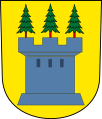
The municipal coat of arms is eloquent ( blazon : three green fir trees with red trunks in silver on green ground ); it has been used as the municipal coat of arms since 1814 and was introduced by the municipal council on December 29, 1926 as the official municipal coat of arms, albeit with a "floating lawn"; the change of the official coat of arms to the form valid today with a green turf floor dates from October 7, 1940. The Walder municipal coat of arms is similar to the older coat of arms of Olten , which has been in use since at least the 17th century . In the latter, however, the three fir trees stand on a green mountain of three . The municipalities of Wald BE and Wald AR , and also the Austrian forests in Pinzgau and Wald am Schoberpaß , also have three fir trees in their coat of arms, in a slightly different arrangement .
The map by Jos Murer (1566) shows coats of arms for Hischwil (Huszwil), Hittenberg (Hitenberg), Windegg , Tobel (Tüfenhof or Strickenberg Castle), Batzberg Castle (Batzenberg), Fründsberg Castle and Laupen (Loupenheim), not but for the forest marked as a church village. The coat of arms of Laupen is a tower with three peaks, with a tree on each pinnacle. The old coat of arms of Laupen is used for forest in the office disk of the Grüningen rule from 1587 . This coat of arms is apparently the basis for the coat of arms of the political municipality of Wald with three fir trees (but without a tower) since the restoration period . The canton map by Hans Conrad Gyger (1667) lists some of the coats of arms mentioned with tinging : Laupen: A gray castle in gold with three green fir trees on its three battlements . Fründsberg : In silver, a golden six-pointed star above a green six-pointed mountain . Hittenberg (Hüttenberg): In silver a black lion . Windegg: A golden double lily in blue (Murer also has a double lily stick, or a glaive stick with two ends). Tobel: (Tobel, Strickenberg): In gold, a red pole with three gold six-pointed stars . Batzenberg: Sheathed in silver and black, a silver bar in the black head of the shield .

Forest coat of arms in the Grüninger coat of arms disk (1587)
Laupen coat of arms in the Gyger map (1667)

Coat of arms of the forest around 1900 (after a Kaffee Hag collective picture)

Wald municipal coat of arms (1926–1939), with floating lawn

Municipal coat of arms since 1940


population
At the end of 2018, the forest had 9,926 inhabitants (population density 393 inh. / Km 2 ) in a total of around 4,700 households. The proportion of foreigners was 26.4%. There was a slight decrease in population in the 1970s (as of 1980: 7,540) and in the 1990s (as of 1999: 8,263). The population has grown steadily since the 2000s (average growth in the period 2000–2018 of 1.0% annually).
| year | 1634 | 1670 | 1739 | 1800 | 1850 | 1900 | 1950 | 1970 | 1980 | 1990 | 2000 | 2010 |
|---|---|---|---|---|---|---|---|---|---|---|---|---|
| Residents | 574 | 1'200 | 2'124 | 3,083 | 3,808 | 6,677 | 7,163 | 8,185 | 7,540 | 8,251 | 8'421 | 8,961 |
30.6% of the population belong to the Evangelical Reformed Church and 29.8% to the Roman Catholic Church (as of December 31, 2018). The Evangelical Free Church of Chrischona and the Evangelical Methodist Church are also represented in Wald .
The average taxable income of natural persons in 2015 was CHF 50,200 (canton: CHF 66,500), the median CHF 43,000 (canton: 50,400). The forest is therefore in a slightly worse position financially than the cantonal average and benefits from the cantonal financial equalization with around CHF 22 million per year (CHF 2,300 per year and inhabitant). The social welfare rate was 2.1% (canton: 3.1%) and the unemployment rate 3.0% (canton: 2.9%).
politics
In the 2015 National Council elections (turnout 41.1%), the SVP received 38.3% of the votes (average canton of Zurich: 30.7%), the SP 18.1% (ZH: 21.4%), the FDP 11, 1% (ZH: 15.3%), the Greens 8.9% (ZH: 6.9%), the GLP 6.3% (ZH: 8.2%), the CVP 4.5% (ZH: 4.2%), the BDP 3.6% (ZH: 3.6%), the EDU 3.2% (ZH: 2.1%), and the EVP 2.8% (ZH: 3.1% ). Ernst Kocher from SVP has been the mayor since 2014 .
| Members of the Walder Municipal Council (2018-2022) | |||
|---|---|---|---|
| Surname | Taking office | function | Political party |
| Ernst Kocher | 2002/2014 | Mayor | SVP |
| Albert Hess-Wittwer | 2006 | Infrastructure | SVP |
| Rico Croci violinist | 2006 | Spatial development and construction | Green |
| Rosaria Peter | 2014 | Safety and health | FDP |
| Urs Cathrein | 2014 | Finances | FDP |
| Andreas Odermatt | 2015 | Social | SVP |
Business
Of the former large number of factories, only a few are now involved in textile processing. They try to counter the rapid technological development and global competitive pressure with creativity, quality thinking, innovation and specialization. Other manufacturers have switched to the production of foodstuffs, sold buildings or rented their premises as real estate companies. New, future-oriented companies have settled in the buildings: metal and plastic processing companies, manufacturers of apparatus for the food and pharmaceutical industries, sales outlets and various smaller businesses. The distinctive "Kosthäuser" (apartment buildings for factory workers at the time) are also rented or sold. Around 480 companies of various sizes are currently active in the municipality of Wald, from industry, trade and services to retail.
The largest employer in the municipality is the Höhenklinik Wald (425 employees in 2017).
There are 25 restaurants and 2 hotels (56 hotel beds) in the municipality.
In 2017, a total of 77 farms with 181 employees were active on an agricultural area of 1426 hectares in the municipality, 49 of which were full-time farms. The cattle herd was 2506, of which 1027 cows, 942 pigs and 380 sheep. On the Alp Scheidegg graze in the summer ha around 150 cattle on the 38th
traffic
Wald is on the main road 15 Rapperswil - Schaffhausen (Rütistrasse; Tösstalstrasse) . The next motorway connections are in Rüti, Dürnten and Eschenbach ( Oberland motorway A53 ).
On the rail network it is served by the S 26 Winterthur - Bauma - Rüti ZH of the Zurich S-Bahn . There are also the following bus lines, which are operated by the Zurich Lake and Oberland Transport Authority (VZO):
- 854 Rüti station - Wald - Gibswil - Fischenthal - Steg - Bauma station
- 885 Rapperswil railway station - Kempraten - Rüti - Wald - Laupen - Goldingen - Atzmännig
- 892 Wald train station - rehabilitation center
- 893 Wald train station - Farnboden - Ober-Feld - Wald train station (circular route)
Attractions
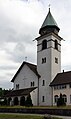
- Reformed Church (1756)
- Catholic Church St. Margarethen (1926/27)
- former pilgrim hostel for the Red Sword (16th century)
- Windegg Manor (1709)
- several manufacturers' villas (19th century)
- several former factory buildings (19th / 20th century)
- Upper Baliken ruin
Personalities
- Robert Grimm (1881–1958), politician and publicist
- Hans Coray (1906–1991), artist and furniture designer
- Heinrich Brändli (1938–2018), engineer and professor at ETH Zurich
- Emil Zopfi (* 1943), writer
- Nicolas Lindt (* 1954), writer
- Jürg Brändli (* 1971), writer, screenwriter and journalist
- Daniel Hildebrand (* 1977), musician
photos

Wald station

Bahnhofstrasse in forest

Reformed church in forest
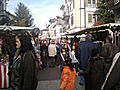
Autumn market in forest
The Catholic Church of St. Margareten
Güntisberg
Hiltisberg

Laupen

Mettlen


_IMG_9483.JPG)
_IMG_9478.JPG)

_IMG_9505.JPG)
literature
- Martin Illi: Forest (ZH). In: Historical Lexicon of Switzerland . 2014 .
- Toby Matthiesen : The pale of time: a Zurich Oberland textile area in transition . Chronos, Zurich 2010, ISBN 978-3-0340-1035-1 .
- Hermann Fietz: The art monuments of the canton of Zurich, Volume II: The districts of Bülach, Dielsdorf, Hinwil, Horgen and Meilen. (= Art Monuments of Switzerland. Volume 15). Edited by the Society for Swiss Art History GSK. Bern 1943. DNB 365803049 .
Web links
- Official website of the community of Wald ZH
- Statistical data for the municipality of Wald ZH
- Forest local history museum
- Village chronicle (wald360.ch)
- Walder magazine
Individual evidence
- ↑ Permanent and non-permanent resident population by year, canton, district, municipality, population type and gender (permanent resident population). In: bfs. admin.ch . Federal Statistical Office (FSO), August 31, 2019, accessed on December 22, 2019 .
- ↑ Data on the resident population by home, gender and age (community profile). Statistical Office of the Canton of Zurich, accessed on December 22, 2019 .
- ↑ a b c d e f statistik.zh.ch (community portraits)
- ↑ map.geo.admin.ch (accessed on March 28, 2016)
- ↑ Schweizerisches Idiotikon , Volume XV, Column 382 f., Article Usse n wacht .
- ↑ a b c F. Schulthess, Memorabilia Tigurina; or, Chronicle of the Memories of the Canton of Zurich 1850 to 1860 (1870), p. 684 .
- ↑ a b c d e cf. Zingg, Urs-Peter: Wald im Zürcher Oberland 1994, p. 6
- ↑ See Alfred Helfenstein: The name of the Pilatus area. Keller, Luzern 1982, ISBN 3-85766-004-X , pp. 46 and 49.
- ↑ Lexicon of Swiss municipality names . Edited by the Center de Dialectologie at the University of Neuchâtel under the direction of Andres Kristol. Frauenfeld / Lausanne 2005, p. 949.
- ↑ «The majestic timber frame building was built in 1709 by the tanner Hans Krauer and his wife Maria Brändli. In its grandeur, it is one of the few witnesses of an increased self-confidence of the rural patriciate in the otherwise rather modest Zurich Oberland. A historic room has been located on the ground floor since 1937 and is still accessible as part of the local history museum. » wald360.ch (accessed February 16, 2019).
- ↑ "The village of Wald in the Zürcher Oberland was once surrounded by a number of small clearing lords. Their centers were castles of modest size, most of which were abandoned at an early stage. There were four such structures at the entrance to Wald through the Jona valley. On the south side the castles Strickenberg and Batzberg, on the north side the castles Unteres and Oberes Baliken. The latter is the only one of which structural remains can still be seen today. " ( Upper Baliken (burgenwelt.org) ). "Fründsberg was once one of those many small clearing castles that appear in the vicinity of the village of Wald." ( Fründsberg (burgenwelt.org) ).
- ↑ a b c d e f Friedrich Vogel, Die alten Chroniken: or Memories of the city and landscape of Zurich from the oldest times to 1820 (1845), 799–801 .
- ↑ Thomas Fassbind, From the Battle of Sempach up to and including the Peace of 1450 (1833), Chapter 45, pp. 181ff .
- ↑ Heinrich Krebser, The first population directory of the community of Wald from 1634. Supplemented by a study of the first settlements in our community, the families named in the directory and the manual activities of their residents until around 1700 (1952).
- ↑ a b c Gerold Meyer von Knonau: The Canton of Zurich, historically, geographically and statistically portrayed from the oldest times to the present. A handbook and house book for everyone (= historical-geographical-statistical painting of Switzerland. Volume I). Huber, St. Gallen / Bern 1846, p. 520 ( digitized version ).
- ↑ wald-zh.ch (Customs)
- ↑ Schnabelgeissen are known from the customs of Mettmenstetten and Ottenbach and also from Hasler Ubersitz . See Paul Geiger : Atlas der Schweizerischen Volkskunde (1950), p. 262; Eduard Hoffmann-Krayer , Hans Bächtold-Stäubli (Hrsg.): Animal disguise, in: Concise dictionary of German superstition (1941).
- ↑ August Itel: Silvesterchlausen in Wald, in: Rolf Thalmann (Ed.): The year of Switzerland in festival and custom (1981), p. 48; Heinrich Krebser: Klaus customs in the Zurich Oberland, in: Schweizer Volkskunde 30 (1940), 92–97; Heinrich Krebser: Old customs of the forest landscape, in: Forest in the Zürcher Oberland, local history pictures from three centuries (1951), 50–53; Heinrich Krebser: De Chlaus chunnt !, in: Us eusere Walder Heimet 89 (December 1965). The custom has been organized by the local museum commission since the 1980s, the chlice and snap donkeys roam the outside watch in the afternoons and meet at 6.30 p.m. for a parade from the train station to Schwertplatz ( heimatmuseum-wald.ch ): «[The New Year's Eve cheats are back] to to seven pairs (Schnappesel and Chläuse) […] on the last day of the year in the Aussenwachten and in the village [make] the rounds. » ( Us eusere Walder Heimet, November 1989), quoted from Schweizerisches Idiotikon , Vol XV 382 f .
- ↑ 125 years of the Tösstalbahn , train number 7.13, IG Tösstallinie (summer 2001).
- ^ Helmut Meyer, Bernhard Schneider: Mission and Diakonie: the history of the Evangelical Society of the Canton of Zurich. Chronos, Zurich 2011, p. 85. Patrick Zehnder: Jakob Oberholzer. In: Historical Lexicon of Switzerland . 2011 .
- ^ Barbara Weinmann, Another Civil Society: Classical Republicanism and Communalism in the Canton of Zurich in the Late 18th and 19th Centuries (2002), p. 286 .
- ↑ Markus Bürgi: Heinrich Hess. In: Historical Lexicon of Switzerland . 2007 .
- ↑ Chronicle (heimatmuseum-wald.ch)
- ↑ a b Martin Illi: Johannes Honegger. In: Historical Lexicon of Switzerland . 2006 .
- ↑ Otto & Joh. Honegger AG ( Memento of the original from March 9, 2015 in the Internet Archive ) Info: The archive link was inserted automatically and has not yet been checked. Please check the original and archive link according to the instructions and then remove this notice.
- ↑ Archived copy ( Memento of the original from May 3, 2013 in the Internet Archive ) Info: The archive link was inserted automatically and has not yet been checked. Please check the original and archive link according to the instructions and then remove this notice.
- ^ Hannes Strebel: Hueb weaving mill - living at lofty heights. 2009.
- ↑ A tower goes on a journey. In: Tages-Anzeiger.
- ^ A b Peter Ziegler: The municipal coat of arms of the Canton of Zurich (= communications from the Antiquarian Society in Zurich. Volume 49). Report House, Zurich 1977, p. 103 .
- ^ Hugo Dietschi, Miscellen: The coat of arms of Olten , yearbook for history of Solothurn 12 (1939).
- ↑ https://www.wald-zh.ch/waldzhinzahlen (accessed on February 16, 2019)
- ↑ before 1814: parish or municipality of Wald, not exactly congruent with the political municipality from 1814.
- ↑ statistik.zh.ch (denomination) (accessed on February 16, 2019).
- ↑ Historically the "Free Forest Community", which later joined the Swiss Chrischona Association. chrischona-wald.ch .
- ↑ emk-wald.ch "Our community in Wald goes back to the early 1880s and has been at home in the chapel at Gartenstrasse 6 since 1908."
- ↑ Financial equalization (statistik.zh.ch) : 2015: CHF 21,873,524 (CHF 2,348 per inhabitant); 2018: CHF 22,317,870 (CHF 2,327 per inhabitant).
- ^ Renewal election of the municipal council term of office 2018–2022, minutes of the election results April 22, 2018
- ↑ See Urs-Peter Zingg: Forest in the Zurich Oberland. 1994, p. 11.
- ^ Stefan Hotz, "Sanatorium Wald is preserved", NZZ December 19, 2014.
- ↑ Wald (brochure) Community of Wald ZH. 2nd edition (January 2018).
← Previous location: Fischenthal | Forest ZH | Next town: Rüti ZH →