Laupen ZH
| Laupen | ||
|---|---|---|
| State : |
|
|
| Canton : |
|
|
| District : | Hinwil | |
| Political community : | Forest | |
| Postal code : | 8637 | |
| Coordinates : | 712.71 thousand / 235969 | |
| Height : | 600 m above sea level M. | |
| Residents: | 1928 | |
| map | ||
|
|
||
Laupen is a village in the municipality of Wald in the Swiss canton of Zurich . Laupen is also known in modern times as the "largest outside guard " in Wald, but historically it was not an outside guard, but an independent civil parish and one of six guard districts and six school communities (school cooperatives) of the municipality of Wald.
geography
Laupen is on the border with the canton of St. Gallen , in the south-east of the Walder municipality. The Laupen guard district includes, in addition to the village of Laupen itself (consisting of the districts Oberlaupen and Unterlaupen): the Winkel settlement and the Altweid, Bär and Au farms to the east and southeast of the village center (on the canton border; the neighboring hamlet of Diemberg was historically also part of Laupen , but is now in the municipality of Eschenbach SG ), the Diezikon and Hubwies settlements with the Am Bach farm northeast of Laupen, the hamlets Bebikon and Morgen and the Nahren (Narren) farm north of Laupen the Töbeli farm on Diezikonerbach, Hinternord and Chefi / Kefa (historically swampy pastureland between forest and Laupen, today built over), the Neuhaus farm near Hinternord on the eastern flank of the Batzberg . The sergeant laupen district borders in the northwest on the watch District Forest, southwest of the Guard District Güntisberg and the north by the district guard Hittenberg . The Diezikonerbach rises at the Höhenklinik Wald (Hittenberg) and flows through Laupen, and finally at Diemberg into the Lattenbach. The watershed between Lattenbach and Jona runs between Chefi and Hinternord.
The Laupenstrasse leads from Wald to Laupen (in Laupen Hauptstrasse , then Walderstrasse ), which connects the Jonatal with the See-Gaster district and via Ricken with the Toggenburg . The bus route 885 serves the route Rapperswil - Kempraten - Rüti - Wald - Laupen - Goldingen - Atzmännig .
history
Laupen has been settled since the 13th century. Diezikon is mentioned for the first time in 1263, Bebikon in 1264. A Laupen castle (Laupenheim, Laubenheim) has existed since the late Middle Ages, but it was not documented until 1504. The exact location of the castle is unknown.
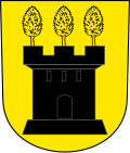
The map by Jos Murer (1566) as a coat of arms for Laupen (Loupenheim) a tower with three battlements, with a tree on each battlement. In Murer these are still deciduous trees (the field name Laupen is based on the word foliage ), but in the canton map by Hans Conrad Gyger (1667) the coat of arms appears with three fir trees ( a gray castle in gold with three green fir trees on its three pinnacles ). The three fir trees in this coat of arms are the basis of the modern municipal coat of arms of the municipality of Wald. The coat of arms of the Grüningen rule (1587) by Christoph Murer (son of Jos Murer) shows the coat of arms for the forest, with a black tower and three golden deciduous trees.
In the 19th century there were four weaving mills in Laupen and Diezikon. The first was opened in 1851 by Jakob Oberholzer in the former Heusser turner's shop in Diezikon. In the 1870s, a railway connection from Wald via Laupen to Uznach and Rapperswil was planned, but it was never realized. A stagecoach connection from Wald via Laupen to Goldingen existed from 1899 to 1927.
Laupen has grown rapidly since the middle of the 20th century, from 1,100 inhabitants in 1960 to 1,928 inhabitants in 2018. An industrial zone has been created on the Chefi plain. The last weaving mill ceased operations in the 1980s and the factory buildings were used in a variety of ways.
literature
- Max Krieg, Werner Brunner Die Aussenwacht Laupen (Part 1) , Us eusere Walder Heimet 271 (March 2018).
- Max Krieg, Werner Brunner Die Aussenwacht Laupen (Part 2) , Us eusere Walder Heimet 272 (July 2018).
- Max Krieg, Werner Brunner Die Aussenwacht Laupen (Part 3) , Us eusere Walder Heimet 273 (October 2018).
- Forest (brochure) , Community of Wald ZH, 2nd edition (January 2018).
Web links
Individual evidence
- ↑ F. Schulthess, Memorabilia Tigurina; or, Chronicle of the Memories of the Canton of Zurich 1850 to 1860 (1870), p. 684 .
- ^ Atlas Suisse (sheet 7, printed 1802).
- ^ Peter Ziegler: The municipal coat of arms of the Canton of Zurich (= communications of the Antiquarian Society in Zurich. Volume 49). Report House, Zurich 1977, p. 103 .


