
Lommis
| Lommis | |
|---|---|
 |
|
| State : |
|
| Canton : |
|
| District : | Münchwilen |
| BFS no. : | 4741 |
| Postal code : | 9506 |
| Coordinates : | 716 346 / 264 025 |
| Height : | 475 m above sea level M. |
| Height range : | 456–696 m above sea level M. |
| Area : | 8.61 km² |
| Residents: | 1215 (December 31, 2018) |
| Population density : | 141 inhabitants per km² |
| Website: | www.lommis.ch |
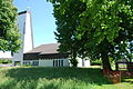
 Lommis, Hauptstrasse, view towards the Catholic Church |
|
| Location of the municipality | |
  |
|
Lommis is a municipality in the Münchwilen district of the Swiss canton of Thurgau . The community consists of the villages of Lommis and Weingarten - Kalthäusern and is located in the Lauchetal near Matzingen .
1995 of the Munizipalgemeinde the Lommis local churches Bettwiesen and Wetzikon separated. Bettwiesen was converted into the Political Municipality of Bettwiesen, Wetzikon became part of the Political Municipality of Thundorf . At the same time, the remaining local parishes of Kalthäusern , Lommis and Weingarten united to form the Political Community of Lommis.
history


Lommis was first mentioned as Loubmeissa in 824 . In 854 the St. Gallen monastery received goods from the Lommis Mark . Around 1200, the Lommis rule, a fief of the Reichenau Abbey and the Counts of Toggenburg , was owned by the Lommis ministerials . 1443 pulled Petermann von Raron Lommis to himself. After further changes, Lommis came to the Fischingen Abbey in 1599 , where it remained until 1798. In church terms, Lommis probably belonged to Affeltrangen in the High Middle Ages ; A priest is mentioned in 1214. In 1529 the community joined the Reformation , but the judge succeeded in re-introducing the mass in 1532. The reformed Lommis was a branch of Matzingen until 1961 and the church was used equally from 1648 to 1966 .
The agricultural and viticulture was until in 1900 of importance of peat mining until 1918. In Lommis a mill dating back to 1625 and sawmill was operated, cotton spinning took place in homework . The industry was the Lauchetal cotton mill from 1810 to 1839, an embroidery factory from 1900 and a shoe factory from 1933. The melioration in 1918 strengthened the dairy industry (cheese dairy). At the beginning of the 21st century, construction companies, the trade (including wood construction, aircraft electronics) and the airfield, which was built in 1962, offered work. From 1970 the community population grew rapidly.
→ see also the history section in the Kalthäusern article
→ see also the history section in the Weingarten TG article
coat of arms
Blazon : Two yellow diagonal strips in blue , the upper one covered with yellow glaze .
The coat of arms was taken over from the judiciary of Lommis and goes back to the Toggenburg servants of Lommis.
population
 |
| 1850 | 1900 | 1950 | 1990 | 2000 | 2010 | 2018 | |
|---|---|---|---|---|---|---|---|
| Political community | 962 | 1101 | 1211 | ||||
| Municipal parish | 1131 | 1061 | 1128 | 1789 | |||
| Local parish | 356 | 341 | 350 | 487 | |||
| source | |||||||
Of the total 1211 inhabitants of the municipality of Lommis in 2018, 137 or 11.3% were foreign nationals. 418 (34.5%) were Roman Catholic and 403 (33.3%) Protestant Reformed. The village of Lommis had 805 residents at that time.
economy
In 2016, Lommis offered 356 jobs (converted to full-time positions). Of these, 9.7% were employed in agriculture and forestry, 56.2% in industry, trade and construction and 34.1% in the service sector.
Airfield
There is a small airfield in Lommis ( ICAO code LSZT ). This was built in 1962 and today has a 615 m long grass runway. The airfield is operated by the Thurgau motor flight group.
Attractions
The ruins of the former Spiegelberg Castle, northeast of Weingarten, are already in the municipality of Thundorf.
photos
reformed Church

Interior of the reformed church

Interior of the catholic church
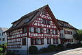
Half-timbered house
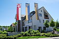
Parish hall

Vineyard

Kaabach

View of the village from the east

Aerial photo from May 9, 2011


Web links
- Official website of the municipality of Lommis
- Website Lommis Airport (LSZT)
Individual evidence
- ↑ Permanent and non-permanent resident population by year, canton, district, municipality, population type and gender (permanent resident population). In: bfs. admin.ch . Federal Statistical Office (FSO), August 31, 2019, accessed on December 22, 2019 .
- ↑ a b Thurgau in figures 2019 . On the website of the Statistical Office of the Canton of Thurgau (PDF file; 1.8 MB), accessed on April 28, 2020.
- ↑ Swiss land use statistics. Completed on July 1, 1912. Published by the Federal Statistical Bureau. ( Memento from April 12, 2016 in the Internet Archive )
- ↑ a b Localities and their resident population. Edition 2019 . On the website of the Statistical Office of the Canton of Thurgau (Excel table; 0.1 MB), accessed on April 28, 2020.
- ↑ a b c population development of the municipalities. Canton Thurgau, 1850–2000 and resident population of the municipalities and change from the previous year. Canton of Thurgau, 1990–2018. On the website of the Statistical Office of the Canton of Thurgau (Excel tables; 0.1 MB each), accessed on April 28, 2020.
- ↑ Lommis, St. James the Elder. On the website of the pastoral area Nollen-Lauchetal-Thur, accessed on November 1, 2019
- ↑ StiASG , Urk. II 59. Online at e-chartae , accessed on June 25, 2020.
-
↑ a b c
Erich Trösch: Lommis. In: Historical Lexicon of Switzerland .
These sections are largely based on the entry in the Historical Lexicon of Switzerland (HLS), which, according to the HLS's usage information, is under the Creative Commons license - Attribution - Share under the same conditions 4.0 International (CC BY-SA 4.0). - ↑ a b municipal coat of arms . On the website of the State Archives of the Canton of Thurgau, accessed on December 8, 2019
- ^ National map of Switzerland 1: 25,000, sheet 1073 Wil, 2014.
Aadorf | Bed meadows | Bichelsee-Balterswil | Braunau | Eschlikon | Fischingen | Lommis | Münchwilen | Rickenbach | Sirnach | Tobel-Tägerschen | Wängi | Wilen
Former communities: Aawangen | Anetswil | Au | Balterswil | Bichelsee | Busswil | Dussnang | Ettenhausen | Guntershausen | Hofen | Holzmannshaus | Horben | Cold houses | Krillberg | Littenheid | Oberhofen near Münchwilen | Oberwangen | St. Margarethen | Tagerschen | Tannegg | Tobel | Tuttwil | Wallenwil | Vineyard | Wiezikon | Wittenwil
Canton of Thurgau | Districts of the Canton of Thurgau | Municipalities of the Canton of Thurgau