Matzingen
| Matzingen | |
|---|---|
| State : |
|
| Canton : |
|
| District : | Frauenfeld |
| BFS no. : | 4591 |
| Postal code : | 9548 |
| UN / LOCODE : | CH MZI |
| Coordinates : | 712 532 / 264 322 |
| Height : | 450 m above sea level M. |
| Height range : | 433–619 m above sea level M. |
| Area : | 7.68 km² |
| Residents: | 2918 (December 31, 2018) |
| Population density : | 380 inhabitants per km² |
| Website: | www.matzingen.ch |
|
"Ox" in the center of Matzingen |
|
| Location of the municipality | |
Matzingen [ matsiŋən ] (in local dialect : [ matsiŋːə ]) is a municipality and a town in the district of Frauenfeld of the canton of Thurgau in Switzerland . From 1870 to 2002 Matzingen was a unified municipality .
geography
The village Matzingen located 5 kilometers southeast of Frauenfeld in the Immenberg , old wood-Fuchsberg, the Ristenbühl and Guggenbühl surrounded trough at the Association of Thun Bach and the leeks with the Murg and Lützelmurg . The municipality extends in the north following the course of the Thunbach to the Stählibuck . The districts of Weierhäusli and Gass as well as the hamlets of Ristenbüel, Halingen and Dingenhart also belong to the community.
Matzingen is accessed by the meter-gauge Frauenfeld-Wil railway .
history
The oldest evidence for the place name (Mazcingas) comes from the year 779. It is a formation of the Old High German personal name Maz (z) o with the place name suffix -ing- 'with the followers, the clan of the named'.
The Barons of Matzingen possessed in the Middle Ages , the lower courts . In 1402 Matzingen passed to the rule of Sonnenberg , where it remained until 1798. The village opening dates from 1482. From 1803 to 1817 the local parish of Matzingen and Stettfurt - from 1812 with Dingenhart, Halingen and Ristenbühl - formed the municipal parish of Matzingen.

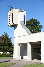
In 894 Matzingen had a church that belonged to Wängi . The collator was the St. Gallen Abbey , and from 1401 the Tobel Commandery . In 1518 Matzingen formed its own parish and was reformed in 1529. In 1971 and 1972 the Catholic Church of St. Joseph was built.
For centuries arable, fruit and vine growing dominated, the latter continued until 1908. After 1850, cattle and dairy farming with a cheese dairy prevailed. Matzingen owned a mill from 1150 to 1996. A pottery was founded in 1863, a spinning mill in 1866, which was converted into a weaving mill in 1878. The connection to the Frauenfeld-Wil-Bahn in 1887 promoted the settlement of new companies, u. a. a furniture factory. In 1919 the Matzingen cider factory was established, which from 1950 produced the half-half drink made from orange juice lemonade and cider . Gehring Cut AG developed from a workshop for agricultural machinery that was founded in 1948 and today manufactures products for vehicle construction and medical technology. The A1 national road enabled an upswing from 1970: Companies in the metal construction and packaging industry settled in Matzingen. From 1965 to 2000 the population doubled.
coat of arms
Blazon : black shield with yellow border .
The coat of arms comes from the barons of Matzingen, who died out in the 14th century.
population
The population has increased significantly in recent years. In 1990 there were still 1,841 people living in the community; as of December 31, 2018, there were 2918 inhabitants.
 |
| year | 1850 | 1900 | 1950 | 1980 | 1990 | 2000 | 2010 | 2018 |
| Residents | 650 | 730 | 1026 | 1520 | 1841 | 2324 | 2529 | 2895 |
Of the total of 2,895 inhabitants of the municipality of Matzingen in 2018, 755 or 26.1% were foreign nationals. 985 (34.0%) were Roman Catholic and 926 (31.10%) were Protestant Reformed. The village of Matzingen had 2809 residents at that time.
Churches
The Evangelical Church of Verena has its own rectory and looks back on a long history; it is first mentioned in a document in 894. The Catholic Church of Saint Joseph was consecrated in 1971 and belongs to the parish of Wängi . The free evangelical community Webi Matzingen was founded in 1994. It belongs to the community association movement plus Switzerland .
Economy and Transport
In 2016, Matzingen offered work for 832 people (converted to full-time positions). Of these, 4.4% worked in agriculture and forestry, 51.1% in industry, trade and construction and 44.5% in the service sector.
Matzingen is located on the Frauenfeld-Wil railway line and is also accessible via the A1 motorway.
Web links
Individual evidence
- ↑ Permanent and non-permanent resident population by year, canton, district, municipality, population type and gender (permanent resident population). In: bfs. admin.ch . Federal Statistical Office (FSO), August 31, 2019, accessed on December 22, 2019 .
- ↑ a b Thurgau in figures 2019 . On the website of the Statistical Office of the Canton of Thurgau (PDF file; 1.8 MB), accessed on April 28, 2020.
- ↑ a b Andres Kristol, Matzingen TG (Frauenfeld) in: Dictionnaire toponymique des communes suisses - Lexicon of Swiss community names - Dizionario toponomastico dei comuni svizzeri (DTS | LSG) , Center de dialectologie, Université de Neuchâtel, Verlag Huber, Frauenfeld / Stuttgart / Vienna 2005, ISBN 3-7193-1308-5 and Éditions Payot, Lausanne 2005, ISBN 2-601-03336-3 , p. 579.
- ↑ a b Localities and their resident population. Edition 2019 . On the website of the Statistical Office of the Canton of Thurgau (Excel table; 0.1 MB), accessed on April 28, 2020.
- ^ Charles Knapp, Maurice Borel, Victor Attinger, Heinrich Brunner, Société neuchâteloise de geographie (editor): Geographical Lexicon of Switzerland . Volume 3: Krailigen - Plentsch . Verlag Gebrüder Attinger, Neuenburg 1905, p. 319, keyword Matzingen ( scan of the lexicon page ).
-
↑ a b c Erich Trösch: Matzingen. In: Historical Lexicon of Switzerland .
These sections are largely based on the entry in the Historical Lexicon of Switzerland (HLS), which, according to the HLS's usage information, is under the Creative Commons license - Attribution - Share under the same conditions 4.0 International (CC BY-SA 4.0). - ↑ a b municipal coat of arms . On the website of the State Archives of the Canton of Thurgau, accessed on December 8, 2019
- ↑ Permanent and non-permanent resident population by year, canton, district, municipality, population type and gender (permanent resident population). In: bfs. admin.ch . Federal Statistical Office (FSO), August 31, 2019, accessed on December 22, 2019 .
- ↑ a b Population development of the municipalities. Canton Thurgau, 1850–2000 and resident population of the municipalities and change from the previous year. Canton of Thurgau, 1990–2018. On the website of the Statistical Office of the Canton of Thurgau (Excel tables; 0.1 MB each), accessed on April 28, 2020.
- ↑ Christian Community Center Webi Matzingen :: MovementPlus :: Evangelical Free Church. In: webimatzingen.ch. Retrieved January 29, 2013 .


