Stahlibuck
| Stahlibuck | ||
|---|---|---|
|
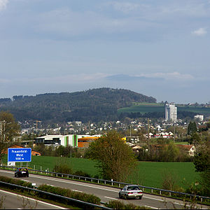
The view to the Stählibuck from the west of the city of Frauenfeld |
||
| height | 655 m above sea level M. | |
| location | east of Frauenfeld , Thurgau , Switzerland | |
| Dominance | 1.7 km → Vorgrüt | |
| Notch height | 30 m ↓ Kardüser | |
| Coordinates | 712 985 / 267 537 | |
|
|
||
| Type | wooded ridge | |
| rock | Molasse - Nagelfluh | |
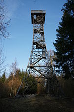
The Stählibuck is a wooded ridge east of the Thurgau canton capital Frauenfeld . As the Horstberg of the Molasse, he is jointly responsible for the landscape after the retreat of the glaciers of the Würm Ice Age . At the culmination point is the Stählibuck Tower , a 26.8 meter high observation tower in steel framework construction . The viewing platform offers a panoramic view of the Thur Valley , the Seerücken , the Immenberg with the Sonnenberg Castle , the Murgtal and the town of Frauenfeld. When the weather is clear, you can see the mountain range of the Alps. The view extends from the Allgäu Alps , over the Alpstein , the Glarner peaks to the highest Bernese Alpine peaks .
Surname
In older records one finds the spelling Stälibuck . Unlike Stählibuck, however, in all newer lettering. This is also the case with the lettering on the panorama board on the platform of the observation tower.
history
The Stählibuck Tower was built in 1908 on the initiative of the Frauenfeld Tourist Office (VVF) at 653 m above sea level. M. erected. The 26.8 meter high tower has 148 steps and is one of the oldest observation towers in steel framework construction in Switzerland.
Routes
The Stählibuck can be easily reached from all sides on hiking trails.


