Sea back
| Sea back | ||
|---|---|---|
|
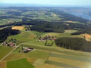
Aerial view of the ridge, the 700 m high plateau can be seen in the foreground. |
||
| height | 721 m above sea level M. | |
| location | Canton of Thurgau , Switzerland | |
| Dominance | 16.15 km → Hombärg | |
| Notch height | 272 m ↓ Sulgen | |
| Coordinates | 719 813 / 278 799 | |
|
|
||
| Type | Molasses | |
| rock | Sandstone | |
|
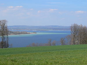
View from Seerücken to Untersee (from front to back: Höri peninsula, Mettnau peninsula , Linzgau ) |
||
The Seerücken is a range of hills running west-east in the canton of Thurgau in Switzerland . The highest point is at 721 m near Salen-Reutenen . The Seerücken is embedded between Lake Constance in the north and the Thur Valley in the south. In the west it is bounded by the Stammerberg near Stammheim ( Oberstammheim / Unterstammheim ), in the east it runs gently to almost Romanshorn . The Seerücken is one of the most rural regions of the Swiss Plateau . It is sparsely populated with individual farms and small villages and is quite heavily forested. The name was proposed by J. A. Pupikofer in 1837 in the canton of Thurgau (= Painting of Switzerland, Volume 17) and has been naturalized since then.
geology
The sea ridge is made up of molasses , which is largely covered by moraine material . There are also individual ice age boulders . The Seerücken is a relic of a plateau, which was otherwise eroded away by ice ages and rivers . Most of the moraines come from the last glacial period ( Würm glacial period ). Moraines from the Riss glaciation may also be found on the highest elevation . Many drumlins can be found on the southern edge of the Seerücken over a length of 15 km (between Frauenfeld and Siegershausen ) .
In the northern part, the molasse consists mainly of mica sandstone , which was brought in from Bavaria by a broad river system around 20 million years ago. There are valuable clues in some places, for example the mica sand pit in Helsighausen , where mica sand is still being mined for roof tile production. In the southern part, you will primarily find Knauersandstones that were transported from the Alps.
In the western part, the Seerücken is hilly and widely over 600 m high. A small plateau is located at 700 m. The eastern part is less hilly and only over 500 m high, in the far east it is over 450 m high.
On the southern flank, the slopes drop gently, while on the northern flank, especially in the higher western part, there are steep slopes. As a result, some ravines with torrents could form on the north side , which can be dangerous during floods and have already caused deaths. Part of the northern part of the Molasse rock, which consists of sandstone , comes to the surface. When there is heavy rainfall, the rocky slopes can become unstable, and in rare cases landslides occur .
climate
Despite its small size and low altitude, the Seerücken has its own characteristic microclimate with influences from the Lake Constance climate .
Temperature: The mean temperature at an altitude of 700 m is 7 ° C. The average temperature in the winter months is −1 ° C, and in summer 15 ° C. In summer the temperature rarely rises above 30 ° C, usually only once a year. In snow-covered hollows, the thermometer can drop to −30 ° C on clear nights when there is no wind.
Precipitation: The annual precipitation averages almost 1000 mm. The least precipitation falls in winter, mostly between May and August. The risk of showers and thunderstorms is slightly higher than in the surrounding area.
Snow: In winter, a closed snow cover forms quite often, which can sometimes last for several weeks. That's why cross-country skiing is also possible on the Seerücken in winter . The highest measured snow cover was about 60 cm. Every hundred years or so, the snow cover can grow to a good 80 cm.
Tornadoes: Weak tornadoes are often observed in the vicinity of the sea ridge . The first and at the same time most striking case recorded in the chronicles occurred on July 19, 1912 near Schönenbaumgarten near Kreuzlingen . In the messages of the Thurgauische Naturforschenden Gesellschaft (No. 20) it says: «It started about 500 m west of the mentioned village of Schönenbaumgarten; made itself noticeable on the ground by a spherical, gray-black appearance from which a columnar hose of cloud grew and, blowing like a locomotive, extended to the clouds. " The tornado left a one-kilometer-long, interrupted swath with fallen trees, some of which were completely limbed. The maximum wind speed was subsequently estimated at 220 to 250 km / h. Another tornado hit the village of Pfyn on August 21, 2005 . It caused considerable property damage to some buildings and touched the ground for a distance of three kilometers. This is the longest damage lane caused by a tornado that has been registered in the Swiss plateau so far. The maximum wind speed in this case was about 150 km / h and the tornado lasted about five minutes.
economy
The Seerücken is very rural with many farms. The region is known for growing fruit, especially apples. Small, middle-class restaurants are also quite common. You benefit from gentle tourism (hikers, cyclists, cross-country skiers). Here and there gravel and sand are extracted. Industrial and commercial enterprises are rare and only exist in larger villages. The connection to public transport is limited.
See also
literature
- Gudrun Genenz: The Seerücken. A landscape in time. Genenz, Konstanz 1995, ISBN 3-9804410-3-2 .
- Beat Brechbühl , Simone Kappeler: On the back of the lake. Wolfau-Druck - R. Mühlemann, Weinfelden 1997, ISBN 3-85809-105-0 .
Web links
Individual evidence
- ^ Charles Knapp, Maurice Borel, Victor Attinger, Heinrich Brunner, Société neuchâteloise de geographie (editor): Geographical Lexicon of Switzerland . Volume 5: Switzerland - Tavetsch . Verlag Gebrüder Attinger, Neuenburg 1908, p. 477, keyword Seerücken ( scan of the lexicon page ).


