
Unterstammheim
| Unterstammheim | ||
|---|---|---|
 |
||
| State : |
|
|
| Canton : |
|
|
| District : | Andelfingen | |
| Political community : | Stammheim | |
| Postal code : | 8476 | |
| former BFS no. : | 0042 | |
| Coordinates : | 701 593 / 277 407 | |
| Height : | 433 m above sea level M. | |
| Area : | 7.32 km² | |
| Residents: | 885 (December 31, 2017) | |
| Population density : | 121 inhabitants per km² | |
|
Proportion of foreigners : (residents without citizenship ) |
10.4% (December 31, 2018) | |
| Website: | www.unterstammheim.ch | |
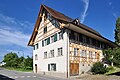
_232.JPG) In Unterstammheim |
||
| map | ||
|
||


Unterstammheim is a village in the political municipality of Stammheim in the canton of Zurich formed on January 1, 2019 . Until December 31, 2018, it formed an independent political municipality .
On September 24, 2017, the voters in Oberstammheim , Unterstammheim and Waltalingen decided to unite to form the political municipality of Stammheim at the beginning of 2019 .
coat of arms
- In red a torn golden tree trunk with three branch stumps
At the beginning of the 16th century, the coat of arms of the Upper Bailiwick of Stammheim already contained a tree trunk with a rootstock ( lower trunk ). The motif continued through the centuries that followed. At the beginning of 1928, the district council of Unterstammheim confirmed the well-known motif as the official coat of arms of the community.
geography

The community of Unterstammheim is located in the northeastern tip of the canton of Zurich in the Zurich wine region near the Thurgau border. Like the neighboring villages of Oberstammheim and Waltalingen, it lies in the uniformly landscaped Stammertal valley .
53% of the former municipality area is used for agriculture, 36% is covered with forest; the settlement area takes up 6% (as of 1996).
history
Stammheim was first mentioned in writing in a deed of donation in 761. The free Aleman Isanhart left his court to the St. Gallen Monastery . During the following centuries the history of Unterstammheim was linked to the monastery.
In 1212 a distinction was first made between Unter- and Oberstammheim, but the two villages formed a unit until 1538. In 1652 they separated into Unterstammheim and Oberstammheim. In 1464 the village was bought by the Canton of Zurich. During the Thirty Years' War , the people of Zurich had two high watches on the Stammerberg, which served as an early warning to the Swiss Confederation in the event of an invasion by those involved in the war in southern Germany. From the front huts you could see the Uetliberg and the Zürichberg .
In 1524 the bailiff of Thurgau, the Schwyz Josef Amberg, arrested the reformed pastor Johannes Oechsli in Stein am Rhein. This enraged numerous Reformed congregations all around, including Unterstammheim. Numerous residents of Unterstammheim moved in front of the Ittingen Charterhouse , which was almost completely destroyed during the Ittinger Storm on July 18 and 19, 1524.
The subordinate of Stammheim, Hans Wirth, was held responsible for this. Together with his sons and the subordinate of Nussbaumen, Burkhart Rüttimann, he had tried in vain to keep the angry farmers from storming the monastery. Against the protest of the reformed city of Zurich they were arrested and brought to justice at the Diet in Baden. On September 28, 1524, Hans Wirth, his son Johannes and Burkhart Rüttimann were beheaded in Baden. Hans's second son, Adrian Wirth, was sent back home.
During the Cold War , the Swiss Army built the Stammheim-Schlattingen locking point with an anti-tank barrier across the Stammertal (Stammheimer Senke).
politics
The last mayor was Werner Haltner ( FDP ).
Cultural assets
The parish hall from 1530 is well preserved and is still in use today. The parish hall is on the first floor and has almost 30 coats of arms. The oldest is from 1531 and was given to the lower chambers by the city of Diessenhofen .
In addition, Stammheim is considered to be one of the best preserved timber frame villages in Switzerland. In order to maintain this, few or no new buildings or conversions are carried out in the village center. Some of the buildings are under homeland security.

church

Parish hall
Girsperger farm

Half-timbered houses at Kellhofstrasse 8, 4 & others
_262.JPG)
_256.JPG)


Leisure and customs
Association
Around 50 clubs are registered in the Stammertal, covering a wide range of leisure activities and entertainment.
Carnival fire
There used to be a great rivalry among the communities in the Stammertal valley. The hostilities culminated in the annual building of the carnival bonfires . Actually there to symbolically drive away the winter, they rather represent a test of strength between the villages. They reached a height of up to 17 m and were built by the high school students of the respective villages during the winter months.
On the eve of the day of Carnival, on which the fires are burned down, the young people organize a watchman evening. In the past, the aim was to attack the other piles of wood and, if possible, set them on fire. Nowadays it really depends on who has the more pompous fireworks available. The focus is on a festival.
economy
In the area around Unterstammheim viticulture is practiced and hops are grown. In addition to the Fricktal and Wolfwil , Unterstammheim is one of the largest hop-growing areas in Switzerland. Sägerei Keller AG and the agricultural cooperative are also major employers.
Sports
The village club BC-Stammheim became Swiss school sports champions in June 2006.
Viewpoints

The on Stammer mountain located observation tower front cabins has a view to the south and southwest over the Stammertal and into the distance. From the tower you have a clear view of the Alps from the Säntis to the Bernese Oberland . The observation tower can be reached in around 45 minutes from the Unterstammheim church.
The Hinterhütten viewpoint offers a clear view of the southern German Hegau with its volcanic landscape and the Swabian Alb on the horizon. Both viewpoints used to belong to the Zurich network of Hochwachten , with which the canton borders were monitored.
Personalities
- Oskar Farner (1884–1958), Protestant clergyman, professor at the University of Zurich and Zwingli researcher
literature
- Martin Illi: Unterstammheim. In: Historical Lexicon of Switzerland .
- Hermann Fietz: The art monuments of the canton of Zurich, Volume I: The districts of Affoltern and Andelfingen (= art monuments of Switzerland. Volume 7). Edited by the Society for Swiss Art History GSK. Bern 1938. DNB 365803030 .
Web links
Individual evidence
- ↑ Data on the resident population by home, gender and age (community profile). Statistical Office of the Canton of Zurich, accessed on December 22, 2019 .
- ^ Spa: A clear yes to Stammheim . Ed .: Andelfinger Zeitung. 26th September 2017.
- ↑ Martin Huber: Zurich's hidden "Russian lock". It is a relic from the Cold War: The Swiss Army's anti-tank barrier, which runs through the entire Stammertal in the north of the canton. In: Tages-Anzeiger . May 24, 2018.
Adlikon | Andelfingen | Benken | Berg am Irchel | Book at Irchel | Badgers | Village | Feuerthalen | Flaach | Flurlingen | Henggart | Humlikon | Kleinandelfingen | Laufen-Uhwiesen | Marthalen | Ossingen | Rheinau | Stammheim | Thalheim an der Thur | Trüllikon | Truttikon | People
Former communities: Oberstammheim | Unterstammheim | Waltalingen
Canton of Zurich | Districts of the Canton of Zurich | Municipalities of the Canton of Zurich