Flurlingen
| Flurlingen | |
|---|---|
| State : |
|
| Canton : |
|
| District : | Andelfingen |
| BFS no. : | 0029 |
| Postal code : | 8247 |
| UN / LOCODE : | CH FLJ |
| Coordinates : | 689 329 / 282151 |
| Height : | 413 m above sea level M. |
| Height range : | 382–575 m above sea level M. |
| Area : | 2.42 km² |
| Residents: | 1438 (December 31, 2018) |
| Population density : | 594 inhabitants per km² |
|
Proportion of foreigners : (residents without citizenship ) |
13.9% (December 31, 2018) |
| Mayor : | Gilbert Bernath ( independent ) |
| Website: | www.flurlingen.ch |
|
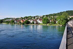
Cholfirst seen from Neuhausen am Rheinfall |
|
| Location of the municipality | |
Flurlingen is a municipality in the Andelfingen district of the canton of Zurich in Switzerland .
coat of arms
- In blue over a golden three-mountain, three silver pruning knives with silver clamps and golden handles, the first with the blade to the left , the other two to the right
geography
The municipality of Flurlingen lies between the Rhine and the western slope of the Cholfirst . Of the municipal area, 18.3% is used for agriculture, 55.8% is covered with forest, 4.2% is traffic area and 17.9% is settlement area, 3.8% is water. On the Cholfirst, at 8 ° 38'50 "east longitude and 47 ° 40'53" north latitude, there is a transmission tower in a steel framework construction with a viewing platform open to the public.
.
population
| Population development | |
|---|---|
| year | Residents |
| 1637 | 170 |
| 1708 | 329 |
| 1850 | 400 |
| 1900 | 902 |
| 1910 | 1,023 |
| 1930 | 895 |
| 1950 | 951 |
| 1960 | 1,049 |
| 1970 | 935 |
| 2000 | 1,248 |
| 2002 | 1,368 |
| 2005 | 1,375 |
politics
The SVP has 25.13%, the SP 16.66%, the FDP 15.36%, the Greens 15.26%, the glp 14.53%, the CVP 5.02%, the BDP 2.12%, the EPP 2.02% and the AL 1.2% of the vote ( National Council election 2019 ).
The community president is the non-party Gilbert Bernath. The executive consists of four members, with all incumbents being independent. (As of May 2020)
history
Flurlingen was first mentioned in a document in 876. In August 876 the abbot of the Rheinau monastery handed over the place Flurlingen to the Klettgau count Gozbert, who later gave his property in Laufen, Mörlen and Flurlingen back to the monastery in 892. In the 10th century, the whole of the Mark, including the parish church in Laufen, came to the Bishop of Constance , who established a manor in Flurlingen with lower jurisdiction over "inheritance and ownership" and the imposition of fines of up to nine shillings. This "Uhwieser Amt" existed until 1798. The bailiwick with central jurisdiction was connected to Laufen Castle and with this in 1544 it came to Zurich . The high court in Flurlingen has always belonged to the County of Kyburg and with it passed to Zurich in 1424 and 1452 respectively.
In the Helvetic Republic , Flurlingen formed its own municipality , and under the mediation constitution, Flurlingen, Dachsen and Uhwiesen were independent communities. With the restoration in 1814, all three places were united. Under the cantonal constitution of 1831, Dachsen broke away, so that only Uhwiesen and Flurlingen together formed a political municipality. In 1841 Flurlingen left this association and became an independent municipality again.
traffic
The community is connected to the right bank of the Rhine by two Rhine bridges. Since 1860 by a road bridge to Schaffhausen , since 1921 by a footbridge to Neuhausen . In addition, the A4 Rhine bridge and the Flurlinger tunnel are on the municipal area.
Sights and culture
Hilari , a carnival-like custom , is always celebrated in mid-January .
literature
- Hermann Fietz: The art monuments of the canton of Zurich, Volume I: The districts of Affoltern and Andelfingen. (= Swiss art monuments. Volume 7). Edited by the Society for Swiss Art History GSK. Bern 1938. DNB 365803030 .
Web links
- Official website of the municipality of Flurlingen
- Statistical data for the municipality of Flurlingen
- Martin Illi: Flurlingen. In: Historical Lexicon of Switzerland .
Individual evidence
- ↑ Permanent and non-permanent resident population by year, canton, district, municipality, population type and gender (permanent resident population). In: bfs. admin.ch . Federal Statistical Office (FSO), August 31, 2019, accessed on December 22, 2019 .
- ↑ Data on the resident population by home, gender and age (community profile). Statistical Office of the Canton of Zurich, accessed on December 22, 2019 .
- ↑ Elections 2019. Accessed May 25, 2020 .
- ↑ Presentation of the story on the website of the municipality of Flurlingen


