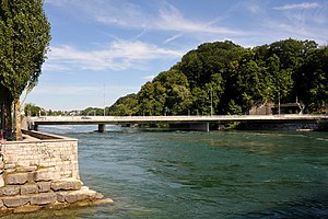
Schaffhausen – Flurlingen bridge over the Rhine
Coordinates: 47 ° 41 ′ 33 " N , 8 ° 37 ′ 37" E ; CH1903: six hundred eighty-nine thousand two hundred and two / 283,099
| Schaffhausen – Flurlingen bridge over the Rhine | ||
|---|---|---|
| use | Road bridge | |
| Crossing of | Rhine | |
| place | Schaffhausen , Flurlingen | |
| construction | T-beam bridge | |
| overall length | 99 m | |
| width | 16.65 m | |
| Longest span | 40 m | |
| Construction height | 1.35 m | |
| building-costs | 14.6 million SFr | |
| start of building | 1987 | |
| completion | 1990 | |
| location | ||
|
|
||
The Rheinbrücke Schaffhausen – Flurlingen is a road bridge that spans the Rhine in Switzerland and connects the city of Schaffhausen with the municipality of Flurlingen in the canton of Zurich on the Grundstrasse . The bridge has one lane in the direction of Flurlingen, two lanes in the direction of Schaffhausen and on the east side a pedestrian and cycle path.
history
The first Rhine bridge between Schaffhausen and Flurlingen was built in 1860 as a 2.4 meter wide wooden walkway for light traffic between the buildings of the Zieglerschen pottery factory on both banks of the Rhine. The construction costs amounted to 15,000 francs and were paid for by public and private contributions. After the establishment of an maintenance fund, the pottery factory paid 4,000 francs for the maintenance of the building. After the use of the bridge by carts with a mass of up to two tons was contractually approved in 1915 , the cantons of Schaffhausen and Zurich took part in the growing maintenance costs. The costs of a major repairs due in 1930 were estimated at 60,000 francs and ultimately led to the complete takeover of the building by the two cantons in 1936. Due to the dilapidation of the footbridge, it was finally closed to motor vehicles and wagons and, at the end of the 1930s, planning for a replacement structure in a better location was started.
The new bridge was built from December 1941 to June 1942 about 110 meters above the wooden footbridge or 300 meters below the Moserdamm . The 87.4 meter long reinforced concrete structure cost 400,000 francs. It had a 3.5 meter wide carriageway and walkways 1.5 meters wide on both sides. The structure was designed in such a way that it was later possible to widen the river downstream and a projected Rhine port could be spanned on the left bank of the Rhine. In addition, the later lowering of the river bed as part of the expansion of the Schaffhausen power plant and the planned expansion for navigation on the Rhine were taken into account.
In order to connect Schaffhausen at a lower level to the national road network , the updated planning made it necessary to have two bridges over the Rhine. The Rhine bridge N4 for through traffic to the north and the Flurlinger bridge as an extension of the Cholfirst tunnel for traffic from the south in the direction of Schaffhausen city center. In addition, the bridge had to continue to accommodate local road traffic between Schaffhausen and Flurlingen. Since the building from 1942 had insufficient load-bearing capacity for the new traffic flows, was too narrow and its geometry was incompatible with the new road layout, a new construction was carried out at the end of the 1980s. The prestressed concrete structure was given three 3.5-meter-wide lanes and a 3.0-meter-wide footpath and bike path on the upstream side. The bridge, completed in 1990, with embankment walls and energy canal, cost 14.6 million francs.
Bridge constructions
Bridge 1942
The superstructure consisted of a two-legged T- beam with a height of 2.36 meters and a plate width of 6.8 meters. The T- beam was tapered above the river piers and had a pressure plate below. In the longitudinal direction there was an 87.4 meter long tanner girder with three fields and spans of 25.4, 36.6 and 25.4 meters as a structural system. The suspension beam in the middle of the bridge spanned 19.8 meters. A shallow foundation on the limestone cliff had been carried out. The edge of the bridge had a gradient of 4 percent towards the middle of the bridge, where the suspension beam was positioned horizontally. By raising the suspension girder and the southern edge field, there was the possibility of a constant gradient of 4 percent in the direction of Flurlingen and, when the Rhine port was being built, the bridge could be extended over the.
Bridge 1990
The superstructure consists of a prestressed T-beam with a uniform height of 1.35 meters and a plate width of 16.55 meters. In the longitudinal direction there is a 99-meter-long continuous beam with three fields and spans of 31, 40 and 28 meters as a structural system. The superstructure is monolithically connected to the two disc-shaped river piers that face the direction of the flow of the Rhine. There is a shallow foundation on the limestone rock. The construction of the superstructure was carried out with a falsework that supported on four pile bays , the river piers and abutments .
literature
- Hans Rudolf Stierli, Erwin Stucki, Paul Wüst: Before the construction of the N4: the Rhine crossings between Stein am Rhein and Eglisau. In: Rhine bridge N4. Edited by the National Road Office of the Canton of Schaffhausen, Meier Verlag Schaffhausen 1995, ISBN 3-85801-112-6
- E. Maier, E. Rathgeb, CF Kollbrunner: New road bridge over the Rhine between Schaffhausen and Flurlingen. In: Schweizerische Bauzeitung. Volume 120, August 22, 1942, pp. 92-94
See also
Web links
|
The next bridge upstream: Schaffhausen power station |
Bridges over the Rhine |
The next bridge downstream: Rhine bridge N4 |


