
Andelfingen district
| Andelfingen district | |
|---|---|
| Basic data | |
| Country: |
|
| Canton : |
|
| Main town : | Andelfingen |
| FSO number : | 0102 |
| Area : | 166.54 km² |
| Height range : | 342–695 m above sea level M. |
| Residents: | 31,372 (December 31, 2018) |
| Population density : | 188 inhabitants per km² |
| map | |
 |
|
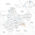
The district of Andelfingen is a rural district in the northeast of the canton of Zurich in Switzerland . The area is also known as the Zürcher Weinland .
geography
The Andelfingen district comprises most of the Zurich wine region . It extends northwest and north of the city of Winterthur , borders the Canton of Thurgau in the east and is bordered by the Rhine in the north and northeast and by the wooded range of hills of the Irchel in the west. From southeast to northwest, the Thur flows through the entire district to its confluence with the Rhine. In the far north of the district, on the border with the canton of Schaffhausen, is the Rhine Falls .
Political communities
| coat of arms | Parish name | Postcode | Population (December 31, 2018) |
Area in km² | Inhabitants per km² |
|---|---|---|---|---|---|
|
|
Adlikon | 8452 | 707 | 6.58 | 107 |
|
|
Andelfingen | 8450 | 2215 | 6.74 | 329 |
|
|
Benken (ZH) | 8463 | 855 | 5.66 | 151 |
|
|
Berg am Irchel | 8415 | 570 | 7.01 | 81 |
|
|
Book at the Irchel | 8414 | 977 | 10.21 | 96 |
|
|
Badgers | 8447 | 1920 | 2.70 | 711 |
|
|
Village | 8458 | 658 | 5.56 | 118 |
|
|
Feuerthalen | 8245 | 3623 | 2.48 | 1461 |
|
|
Flat | 8416 | 1414 | 10.17 | 139 |
|
|
Flurlingen | 8247 | 1438 | 2.42 | 594 |
|
|
Henggart | 8444 | 2239 | 3.03 | 739 |
|
|
Humlikon | 8457 | 487 | 3.68 | 132 |
|
|
Kleinandelfingen | 8451 | 2109 | 10.29 | 205 |
|
|
Laufen-Uhwiesen | 8248 | 1709 | 6.28 | 272 |
|
|
Marthalen | 8460 | 1908 | 14.13 | 135 |
|
|
Ossingen | 8475 | 1641 | 13.09 | 125 |
|
|
Rheinau | 8462 | 1333 | 8.95 | 149 |
|
|
Stammheim | 8468 8476 8477 |
2747 | 23.95 | 115 |
|
|
Thalheim an der Thur | 8478 | 917 | 6.44 | 142 |
|
|
Trullikon | 8466 | 1066 | 9.56 | 112 |
|
|
Truttikon | 8467 | 477 | 4.41 | 108 |
|
|
People | 8459 | 362 | 3.20 | 113 |
| Total (22) | 31,372 | 166.54 | 188 | ||
Changes in the community

Parishes until 1871
Municipalities until 1877

Parishes until 1878

Parishes until 1969

Municipalities until 2012

Municipalities by 2018


- 1872: Split from Adlikon → Humlikon
- 1878: Change of name Dorlikon → Thalheim an der Thur
- 1879: Split from Trüllikon → Truttikon
- 1970: Name change from Grossandelfingen → Andelfingen
- 2013: Merger of the hamlet “Obere Hueb” of the municipality of Buch am Irchel → Neftenbach
- 2019: Merger of Oberstammheim , Unterstammheim and Waltalingen → Stammheim
Civil parishes
The following civil parishes still existed until the end of 2009 :
- Gräslikon (Political Municipality Berg am Irchel )
- Guntalingen (Political Community of Waltalingen )
- Trüllikon (Political Municipality of Trüllikon)
- Wildensbuch (Political Municipality of Trüllikon )
The civil parish of Rudolfingen was dissolved on January 1, 2008 and became part of the Trüllikon political community.
Localities
| Postcode | Name of the place | local community |
|---|---|---|
| Datwil | Adlikon | |
| Niederwil ZH | Adlikon | |
| 8415 | Gräslikon | Berg am Irchel |
| Bebikon | Book at the Irchel | |
| Desibach | Book at the Irchel | |
| Wiler | Book at the Irchel | |
| 8246 | Langwiesen | Feuerthalen |
| 8453 | Old people | Kleinandelfingen |
| 8461 | Oerlingen | Kleinandelfingen |
| Running at the Rhine Falls | Laufen-Uhwiesen | |
| 8212 | Nohl | Laufen-Uhwiesen |
| 8248 | Uhwiesen | Laufen-Uhwiesen |
| 8464 | Ellikon on the Rhine | Marthalen |
| Courtyard | Ossingen | |
| Gisenhard | Ossingen | |
| Langenmoos | Ossingen | |
| Hausen | Ossingen | |
| 8468 | Guntalingen | Stammheim |
| 8477 | Oberstammheim | Stammheim |
| 8476 | Unterstammheim | Stammheim |
| 8468 | Waltalingen | Stammheim |
| 8525 | Wilen b. Neunforn ZH | Stammheim |
| Gütighausen | Thalheim an der Thur | |
| 8465 | Rudolfingen | Trullikon |
| 8465 | Wildensbuch | Trullikon |
Individual evidence
- ↑ Permanent and non-permanent resident population by year, canton, district, municipality, population type and gender (permanent resident population). In: bfs. admin.ch . Federal Statistical Office (FSO), August 31, 2019, accessed on December 22, 2019 .
- ↑ Federal Statistical Office Generalized Limits 2020.
Web links
- Martin Illi: Andelfingen (rule, district). In: Historical Lexicon of Switzerland .