
Zurichberg
| Zurichberg | ||
|---|---|---|
 View from Enge over the lake to the populated western flank of the Zürichberg |
||
| height | 676 m above sea level M. | |
| location | Canton of Zurich , Switzerland | |
| Dominance | 2.24 km → Adlisberg | |
| Notch height | 69 m ↓ Dreiwiesen | |
| Coordinates | 685 197 / 248915 | |
|
||
 From the Lindenhof to the east of downtown Zurich |
||

The Zurichberg ( 676 m above sea level ) is one of Zurich's local mountains . It is located east of the city center between the Limmat and Glatt valleys . Its highest point, the Escherhöhe , is around 270 meters above Lake Zurich .
location
The Zürichberg is the north-western end of a chain of hills between Greifensee / Glattal and Zürichsee / Limmattal, the Pfannenstiel . The Adlisberg and Öschbrig hills, which adjoin the Zürichberg to the southeast , also belong to the city of Zürich and are also mostly forested. To the west of the Zürichberg, the green belt is interrupted by settlement area, where the city of Zürich spreads out in the saddle between the end of the Pfannenstiel and the neighboring Käferberg at Milchbuck and Buchegg in the Glattal.
Development and use
The western flank of the Zürichberg with the quarters Fluntern and Oberstrass is known as Zürich's residential quarter for the rich and the upper class. With Zurich Berg also this residential area is known in the vernacular often. Above the hillside built on with villas there is a forest on the flatter ridge. On the east side, where the Schwamendingen district, which also belongs to the city of Zurich , is located, the forest extends much further down into the valley. The forest of the Zürichberg is popular with those looking for relaxation, sports enthusiasts and walkers.
The Zurich Zoo is located on the Zürichberg . Not far away, which has FIFA headquarters, which moved into in 2006 Home of FIFA .
On the Zürichberg there is a transmission tower for broadcasting VHF radio and television programs with lights ( 47 ° 23 ′ 9.6 ″ N , 8 ° 34 ′ 5.4 ″ E ).
Development
The built-up west side of the Zürichberg is easily accessible by public transport. In the lower part of the city center, there are several tram lines that go back to the first line of the central Zürichbergbahn that opened in 1895 . Another route winds up the mountain to the zoo.
The Rigiblick cable car opens up the residential area further to the west: from a tram stop it overcomes a height difference of 94 m to the edge of the forest. The Polybahn lies at the foot of the Zürichberg: from the valley station on the Limmat, it climbs the lowest slope on the mountain (difference in altitude: 41 meters) to the ETH Zurich . There are currently plans to build a gondola between Schwamendingen and the zoo .
Several tunnels were built for the railway in the vicinity of the Zürichberg: at the southwestern foot to bypass the city center the Lettentunnel , which was later replaced by the Hirschengraben tunnel, and a little west of the Zürichberg the Wipkingertunnel , the oldest connection between the Limmat and Glattal valleys. A little further to the southeast, the Zürichberg tunnel crosses under the neighboring Adlisberg. The Weinberg Tunnel, which opened in 2014, leads in a large loop through the lower slopes on the western slope of the Zürichberg.
history
The name Zürychberg was first mentioned in a document in 1188. The Augustinian monastery of St. Martin stood behind today's zoo until the Reformation . A long Letzi wall ran from the Zürichberg across the Limmat Valley. Its conclusion on the Zürichberg was the Krattenturm , a defensive tower that still adorns the Oberstrass coat of arms . The tower was built in the 14th century and destroyed in 1444. In addition, there were up to two high watches, which the costume group of the Fluntern guild remembered with their own car during the Sechseläuten parade . For the residents on the southern and western slopes, viticulture was the most important source of income for a long time : almost uninterrupted vineyards shaped the mountain in Fluntern and Oberstrass in the steep sections below today's Gladbachstrasse, but were also found in other places, in some cases up to 600 meters above sea level . During the Franco - Russian wars in the 18th century , ramparts were built and battles were fought on the Zürichberg. A memorial commemorates this. The Escherhöhe not far from there is said to be named after Nanny von Escher , who wrote the poem on the memorial.
photos


View to the south

Winter forest on the Zürichberg
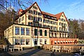
Hotel Zurichberg

Oerlikon and northwest flank

Cable car and Hotel Rigiblick around 1901


Web links
- Hikr.org - Tour description Zürichberg with pictures
- Zürichberg on the ETHorama platform
Individual evidence
- ^ The Zürichbergstrasse. In: Gang dur Züri. Retrieved October 4, 2010 .
- ^ Matthias Dürst: Krattenturm. In: Gang dur Züri. Retrieved June 13, 2014 .
- ↑ On the Gyger map from 1667 you can see two Hochwachten: one at the Allmend, one at the Rigiblick. On the more than 100 years younger floor plan of the city of Zurich and the surrounding area , only one can be found.
- ^ Website of the Fluntern Guild ( Memento from April 26, 2012 in the Internet Archive )
- ↑ Building Department of the City of Zurich, Office for Urban Development (ed.): Baukultur in Zurich: Oberstrass, Fluntern . Verlag Neue Zürcher Zeitung, Zurich 2010, ISBN 978-3-03823-077-9 .
- ^ Emil Zopfi : The new local mountain. In: mountain literature. April 8, 2013, accessed May 27, 2020 .