
Salen-Reutenen
| Salen-Reutenen | ||
|---|---|---|
 |
||
| State : |
|
|
| Canton : |
|
|
| District : | Frauenfeld | |
| Political community : | Homburg | |
| Postal code : | 8508 | |
| former BFS no. : | 4863 | |
| Coordinates : | 718 565 / 279 087 | |
| Height : | 686 m above sea level M. | |
| Area : | 3.56 km² | |
| Residents: | 150 | |
| Population density : | 42 inhabitants per km² | |
 Parish before the merger in 1999 |
||
| map | ||
|
||

Salen-Reutenen , in Swiss German Sale-Rüütene , was a local parish in the Steckborn district of the canton of Thurgau in Switzerland from 1812 to 1998 and belonged to the municipality of Steckborn . On 1 January 1999, the local churches Salen-Reutenen and were Gündelhart-Hörhausen separated from the Munizipalgemeinde Steckborn and the unified community Homburg the political community Homburg combined .
geography
The villages of Salen and Reutenen as well as numerous hamlets, u. a. Götschenhäusli, Sassenloo and Uhwilen are located on a slightly sloping plateau on the ridge south of Steckborn.
history
The two villages were first mentioned in 1272 as Sala and 1634 as Rütinen . In the late Middle Ages , the monasteries Feldbach (Sassenloo, Tägermoos and Uhwilen) and Reichenau as well as the Kreuzlingen monastery were the most important landlords in Salen-Reutenen. The Feldbach monastery also owned the lower court at the aforementioned courts . As so-called high courts, Salen and some houses in Reutenen were directly subordinate to the Thurgau governor, while Hinter-Reutenen belonged partly to the Klingenberg rule and partly to the Feldbach court.
Church-wise, Salen-Reutenen (apart from Götschenhäusli and Hinter-Reutenen) shared the fate of the Steckborn parish, but after the Reformation it formed a kind of Catholic refuge in the reformed Steckborn. In 1862 the Catholics in Reutenen built the St. Antonius Chapel.
In Salen and Reutenen, arable and fruit growing as well as cattle breeding has always been practiced; some weaving in the 19th century. Agriculture also shaped the character of the villages at the beginning of the 21st century.
coat of arms
Blazon : Two torn yellow willows in red .
The uprooted pastures (Salen) indicate the cleared area (Reutenen) in the area of the former municipality of Salen-Reutenen.
population
| year | 1831 | 1850 | 1900 | 1950 | 1990 | 1995 | 2000 | 2010 | 2018 |
| Local parish | 245 | 215 | 165 | 206 | 134 | 151 | |||
| Salen settlement | 22nd | 32 | 34 | ||||||
| Reutenen settlement | 29 | 22nd | 30th | ||||||
| source | |||||||||
Wind power
Salen-Reutenen is one of the locations in the canton of Thurgau that are being examined for their use of wind power . Due to its exposed location on the Seerücken , the energy potential of a wind farm is 29 GWh.
Attractions
The site of a Roman sanctuary is listed on the list of cultural assets in Homburg TG . It is practically on the highest point of the sea ridge. At least two small temple buildings are proven.
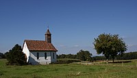
Chapel of St.Antonius in Reutenen

Salen

Day moss


Web links
- The website for wind energy data in Switzerland , accessed on May 13, 2018
Individual evidence
- ↑ Swiss land use statistics. Completed on July 1, 1912. Published by the Federal Statistical Bureau. ( Memento from April 12, 2016 in the Internet Archive )
- ↑ Salen-Reutenen. On the website of the municipality of Homburg, accessed in December 2013
- ↑ Salen-Reutenen on ortsnames.ch (online database), accessed on February 15, 2020
- ↑ Population development of the municipalities. Canton Thurgau, 1850–2000 and resident population of the municipalities and change from the previous year. Canton of Thurgau, 1990–2018. On the website of the Statistical Office of the Canton of Thurgau (Excel tables; 0.1 MB each), accessed on April 28, 2020.
-
↑ a b c d e Erich Trösch: Salen-Reutenen. In: Historical Lexicon of Switzerland .
These sections are largely based on the entry in the Historical Lexicon of Switzerland (HLS), which, according to the HLS's usage information, is under the Creative Commons license - Attribution - Share under the same conditions 4.0 International (CC BY-SA 4.0). - ↑ a b municipal coat of arms . On the website of the State Archives of the Canton of Thurgau, accessed on December 8, 2019
- ↑ Locations and Settlements Directory. Canton of Thurgau, 2005 edition . On the website of the Statistical Office of the Canton of Thurgau (PDF; 1.7 MB), accessed on April 28, 2020.
- ↑ Locations and Settlements Directory. Canton of Thurgau, 2012 edition. On the website of the Statistical Office of the Canton of Thurgau (PDF; 3.4 MB), accessed on May 11, 2020.
- ↑ List of settlements. Canton of Thurgau, edition 2019 . On the website of the Statistical Office of the Canton of Thurgau (Excel table; 0.2 MB), accessed on May 10, 2020.
- ↑ Wind potential study, site assessment part 2 (PDF; 23.1 MB). Department of Home Affairs and Economics, Energy Department, on behalf of the Canton of Thurgau, accessed on May 13, 2018.
- ^ Office for Archeology Thurgau (ed.): Archeology in Thurgau. Huber, Frauenfeld 2010, ISBN 978-3-7193-1541-2 , pp. 302-303. On the website of the Thurgau Archeology Office, PDF; 55.5 MB
Basadingen-Schlattingen | Berlingen | Diessenhofen | Eschenz | Felben-Wellhausen | Frauenfeld | Gachnang | Herdern | Homburg | Hüttlingen | Hüttwilen | Mammers | Matzingen | Muellheim | Nine-shape | Pfyn | Schlatt | Steckborn | Stettfurt | Thundorf | Uesslingen book | Wagenhausen | Warth-Weiningen
Former municipalities: Basadingen | Book near Frauenfeld | Dettighofen | Eschikofen | Fahrhof | Felben | Gerlikon | Gündelhart-Hörhausen | Harenwilen | Herten | Horgenbach | Huben | Islikon | Kaltenbach | Kefikon | Kurzdorf | Langdorf | Langenhart | Lance neunforn | Lustdorf | Mett-Oberschlatt | Mettendorf | Niederneunforn | Niederwil | Walnut trees | Oberneunforn | Oberwil | Rheinklingen | Salen-Reutenen | Schlattingen | Uerschhausen | Uesslingen | Subdivision | Warth | Weiningen | Wellhausen | Wetzikon | Wilen bei Neunforn | Willisdorf
Canton of Thurgau | Districts of the Canton of Thurgau | Municipalities of the Canton of Thurgau