Mettendorf TG
| TG is the abbreviation for the canton of Thurgau in Switzerland and is used to avoid confusion with other entries of the name Mettendorf . |
| Mettendorf | ||
|---|---|---|
| State : |
|
|
| Canton : |
|
|
| District : | Frauenfeld | |
| Political community : | Huettlingen | |
| Postal code : | 8553 | |
| former BFS no. : | 4584 | |
| Coordinates : | 715 290 / 270 914 | |
| Height : | 404 m above sea level M. | |
| Area : | 4.24 km² | |
| Residents: | 345 (December 31, 2018) | |
| Population density : | 81 inhabitants per km² | |
|
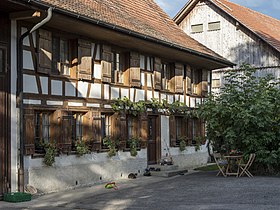
Farmhouse Frohwies 1 in Mettendorf TG |
||
| map | ||
|
|
||
Mettendorf is a village in the municipality of Hüttlingen in the Frauenfeld district in the canton of Thurgau in Switzerland .
Mettendorf formed from 1803 to 1998 a local community of the municipal community Hüttlingen. On January 1, 1999 , Mettendorf merged with the local communities of Eschikofen , Harenwilen and Hüttlingen to form the political community of Hüttlingen.
geography
Mettendorf is located on the Wellenberg north-east of Frauenfeld . Together with Hüttlingen it has a stop on the Winterthur – Romanshorn railway line .
history
Methindorf was first mentioned in a document in 1261. The Counts of Kyburg and Rudolf von Habsburg-Neukyburg were bailiffs of the Dinghof Mettendorf, which belonged to Reichenau Abbey . The lower jurisdiction of Mettendorf was jointly owned by the Reichenau bailiff and the owner of the Wellenberg estate until 1798 . In 1430 Mettendorf received a bailiwick and in 1456 a court was opened . In the Old Zurich War (1436–1450) it was sacked in 1445 by a federal foray, and in 1701 it suffered a village fire.
Mettendorf was parish after Pfyn . After the Reformation , the churchgoers went from Mettendorf to Hüttlingen, although they were still subordinate to Pfyn. Mettendorf has belonged to the parish of Hüttlingen since 1712 .
From the late Middle Ages onwards, Hüttlingen and Mettendorf shared a thousand Jucharten forest, which was eliminated in 1815. Until 1900 agriculture, cattle breeding, dairy farming, fruit growing, beekeeping, viticulture and basketry dominated. A cheese dairy existed from 1885 to 2002. Due to the quiet residential area in Mettendorf, the population has been growing since 1970.
population
| year | 1669 | 1850 | 1900 | 1950 | 1990 | 2000 | 2010 | 2018 |
| Local parish | 305 | 280 | 190 | 234 | 255 | |||
| Locality | 322 | 293 | 345 | |||||
| source | ||||||||
Of the total of 345 inhabitants of the village of Mettendorf in 2018, 28 or 8.1% were foreign nationals. 165 (47.8%) were Protestant Reformed and 63 (18.3%) were Roman Catholic.
coat of arms
Blazon : Divided by blue with a white, striding lion and white-red chess .
Mettendorf was once a fiefdom of the Kyburger and the Habsburg-Neukyburger, later it belonged to Wellenberg and thus indirectly to the city of Zurich . The coat of arms shows how the Habsburg lion strides over the chess of the Lords of Glattbrugg. The lion wears the Zurich colors, the chess the Reichau colors.
Individual evidence
- ↑ Swiss land use statistics. Completed on July 1, 1912. Published by the Federal Statistical Bureau. ( Memento from April 12, 2016 in the Internet Archive )
- ↑ a b c d Localities and their resident population. Edition 2019 . On the website of the Statistical Office of the Canton of Thurgau (Excel table; 0.1 MB), accessed on April 28, 2020.
-
↑ a b c d e
Erich Trösch: Mettendorf. In: Historical Lexicon of Switzerland .
These sections are largely based on the entry in the Historical Lexicon of Switzerland (HLS), which, according to the HLS's usage information, is under the Creative Commons license - Attribution - Share under the same conditions 4.0 International (CC BY-SA 4.0). - ↑ a b c municipal coat of arms . On the website of the State Archives of the Canton of Thurgau, accessed on December 8, 2019
- ↑ Locations and Settlements Directory. Canton of Thurgau, 2005 edition . On the website of the Statistical Office of the Canton of Thurgau (PDF; 1.7 MB), accessed on April 28, 2020.
- ↑ Locations and Settlements Directory. Canton of Thurgau, 2012 edition. On the website of the Statistical Office of the Canton of Thurgau (PDF; 3.4 MB), accessed on May 11, 2020.
Remarks
- ↑ without outside courtyards


