Undercut
| Undercut | ||
|---|---|---|
| State : |
|
|
| Canton : |
|
|
| District : | Frauenfeld | |
| Political community : | Schlatt | |
| Postal code : | 8252 | |
| former BFS no. : | 4534 | |
| Coordinates : | 695 047 / 279895 | |
| Height : | 416 m above sea level M. | |
| Area : | 11.92 km² | |
| Residents: | 915 (1990) | |
| Population density : | 77 inhabitants per km² | |
|
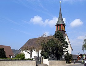
Reformed Church Schlatt in Unterschlatt |
||
| map | ||
|
|
||
Unterschlatt is a settlement and was from 1816 to 1998 a local parish of the former Basadingen municipality in the Diessenhofen district of the canton of Thurgau in Switzerland .
Since January 1st, 1999, Unterschlatt and Mett-Oberschlatt form the political municipality of Schlatt TG in the Frauenfeld district .
geography
The former local community, located between Kohlfirst and Buechberg, borders the Rhine in the north . In addition to the village of Unterschlatt, it included the districts of Dickihof in the southeast, Altparadies with the former Paradies monastery and the industrial estate Neuparadies with the Schlatt train station on the Schaffhausen – Kreuzlingen railway line, which was built in the 19th and 20th centuries . In the south it bordered the Zurich municipalities of Truttikon and Trüllikon .
history
Schlatt was first mentioned in 1263 as in inferiori villa Slatthe. In flocks forest on the Rhine in 1912, a Roman excavated Watchtower and has since eroded. In 1925 the remains of a villa rustica , a bronze bowl and a Mercury statuette were found. 875 existed the settlements Schwarzach (Swarza) and Hierolteswilare. The church of St. Peter in Schwarzach, mentioned in 1162, was part of the furnishings of the Paradies monastery, which was newly built there after 1253 . In 858 the Rheinau monastery owned goods and rights in Schlatt, around 1150 the Allerheiligen monastery , after 1250 also the St. Katharinental monastery and the Paradies monastery. The jurisdiction lay with the Vogtei Diessenhofen and from 1460 to 1798 with the city of Diessenhofen .
In the Second Coalition War of 1799, Schlatt was in the battle zone of the Russians and French for a long time . The Austrians succeeded in crossing over the Rhine to the south in Schaaren near the monastery. A memorial plaque reminds of this today.
From 1803 to 1816, Unterschlatt belonged to the municipality of Diessenhofen.
| year | 1831 | 1850 | 1900 | 1950 | 1990 | 2000 | 2010 | 2018 |
| Local parish | 466 | 631 | 633 | 914 | 915 | |||
| Locality | 698 | 788 | 875 | |||||
| source | ||||||||
In 1162 a chapel is mentioned in Unterschlatt, in 1275 a pastor is mentioned. Later it was subordinate to the parish of Stammheim . In 1714 a reformed church was built in Unterschlatt and in 1769 its own parish was created.
In addition to the three-part economy until around 1800, fruit and horticulture was carried out; in the 19th century a cheese dairy was established. From 1894, the Schaffhausen – Kreuzlingen railway line facilitated the industrial dismantling of the alumina layers. In 1922 the Keller-Ziegeleien AG started operations.
coat of arms
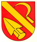
Blazon : The coat of arms of the local community Mett-Oberschlatt is diagonally divided by red with a yellow sickle and a yellow ploughshare .
Sickle and ploughshare represent the agricultural character of the community. The colors symbolize the earlier belonging to the Vogtei and Hochgericht Diessenhofen.
Attractions
→ see section Sights in the article Schlatt TG
Web links
Individual evidence
- ↑ Swiss land use statistics. Completed on July 1, 1912. Published by the Federal Statistical Bureau. ( Memento from April 12, 2016 in the Internet Archive )
-
↑ a b c d e f Erich Trösch: Unterschlatt. In: Historical Lexicon of Switzerland .
These sections are largely based on the entry in the Historical Lexicon of Switzerland (HLS), which, according to the HLS's usage information, is under the Creative Commons license - Attribution - Share under the same conditions 4.0 International (CC BY-SA 4.0). - ↑ Locations and Settlements Directory. Canton of Thurgau, 2005 edition . On the website of the Statistical Office of the Canton of Thurgau (PDF; 1.7 MB), accessed on April 28, 2020.
- ↑ Locations and Settlements Directory. Canton of Thurgau, 2012 edition. On the website of the Statistical Office of the Canton of Thurgau (PDF; 3.4 MB), accessed on May 11, 2020.
- ↑ List of settlements. Canton of Thurgau, edition 2019 . On the website of the Statistical Office of the Canton of Thurgau (Excel table; 0.2 MB), accessed on May 10, 2020.
- ^ Community merger in the canton of Thurgau: Schlatt. On the website of the Swiss Coats of Arms and Flags Foundation, accessed on December 20, 2019
- ^ Municipal coat of arms . On the website of the State Archives of the Canton of Thurgau, accessed on December 8, 2019


