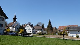
Willisdorf
| Willisdorf | ||
|---|---|---|
| State : |
|
|
| Canton : |
|
|
| District : | Frauenfeld | |
| Political community : | Diessenhofen | |
| Postal code : | 8253 | |
| former BFS no. : | 4542 | |
| Coordinates : | 697 567 / 282005 | |
| Height : | 415 m above sea level M. | |
| Area : | 3.40 km² | |
| Residents: | 136 (December 31, 2018) | |
| Population density : | 40 inhabitants per km² | |
|
Willisdorf |
||
| map | ||
|
|
||
Willisdorf is a former municipality and a village in the municipality of Diessenhofen in the Frauenfeld district of the canton of Thurgau in Switzerland .
From 1812 to 1999, the local community of Willisdorf and St. Katharinental belonged to the municipal community of Diessenhofen in what was then the Diessenhofen district . On January 1, 2000 , the local parishes of Willisdorf and Diessenhofen merged to form the political municipality of Diessenhofen.
history
The settlement was first mentioned in 846 as Wilihdorf . Almost all of the goods that the St. Gallen Monastery in Willisdorf had owned from the early Middle Ages onwards was taken over by St. Katharinental Monastery after 1246 through purchase, exchange and donations. In the Middle Ages the high level of jurisdiction lay with the Kyburg - Habsburg office of Diessenhofen. The city of Diessenhofen received high jurisdiction in 1460 and lower jurisdiction in the 16th century and exercised both until 1798.
Ecclesiastically Willisdorf was always part of Basadingen , with the exception of Kundelfingerhof, whose Reformed residents were ecclesiastical according to Schlatt , while the Catholic residents were subordinate to the Paradies monastery. The St. Sebastian chapel was probably built in the 12th / 13th centuries. Built in the 16th century and renovated from 1966 to 1971.
The residents cultivated fields, meadows and fruit. The mill in Kundelfingen mentioned in 1263 existed until 1910, the mill in Willisdorf, also mentioned in 1263, has been operated by the Bachmann family since 1857 and was electrified in 1948, the Rottmühle mentioned in 1279 burned down in 1891. In addition to operations for paint production and a company for precision tools, there has been a fish farm since 1910.
→ see also article St. Catherine's Monastery
population
| year | 1831 | 1850 | 1880 | 1900 | 1950 | 1990 | 2000 | 2010 | 2018 |
| Local parish | 59 | 180 | 557 | 475 | 528 | 343 | |||
| Locality | 100 | 116 | 136 | ||||||
| source | |||||||||
Of the total of 136 inhabitants in Willisdorf in 2018, 21 or 15.4% were foreign nationals. 67 (49.3%) were Protestant Reformed and 26 (19.1%) Roman Catholic.
Attractions
The list of cultural assets in Diessenhofen includes the St. Katharinental monastery with the associated grain barn and the folklore collection located therein, the St. Sebastian Catholic chapel and the Bachmann mill.
literature
- Alfons Raimann: The art monuments of the Canton of Thurgau, Volume V: The Diessenhofen district. Edited by the Society for Swiss Art History GSK. Bern 1992 (Art Monuments of Switzerland, Volume 85). ISBN 3-909158-73-0 . Pp. 305-317.
Web links
Individual evidence
- ↑ Swiss land use statistics. Completed on July 1, 1912. Published by the Federal Statistical Bureau. ( Memento from April 12, 2016 in the Internet Archive )
- ↑ a b c d Localities and their resident population. Edition 2019 . On the website of the Statistical Office of the Canton of Thurgau (Excel table; 0.1 MB), accessed on April 28, 2020.
-
↑ a b c d
Erich Trösch: Willisdorf. In: Historical Lexicon of Switzerland .
These sections are largely based on the entry in the Historical Lexicon of Switzerland (HLS), which, according to the HLS's usage information, is under the Creative Commons license - Attribution - Share under the same conditions 4.0 International (CC BY-SA 4.0). - ↑ Locations and Settlements Directory. Canton of Thurgau, 2005 edition . On the website of the Statistical Office of the Canton of Thurgau (PDF; 1.7 MB), accessed on April 28, 2020.
- ↑ Locations and Settlements Directory. Canton of Thurgau, 2012 edition. On the website of the Statistical Office of the Canton of Thurgau (PDF; 3.4 MB), accessed on May 11, 2020.
Remarks
- ↑ with outside courtyards


