
Eschikofen
| Eschikofen | ||
|---|---|---|
 |
||
| State : |
|
|
| Canton : |
|
|
| District : | Frauenfeld | |
| Political community : | Huettlingen | |
| Postal code : | 8553 | |
| former BFS no. : | 4581 | |
| Coordinates : | 717 949 / 271 156 | |
| Height : | 410 m above sea level M. | |
| Area : | 1.70 km² | |
| Residents: | 186 (December 31, 2018) | |
| Population density : | 109 inhabitants per km² | |
_TG.jpg) Wooden houses in Eschikofen |
||
| map | ||
|
||

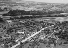
Eschikofen is a village in the Swiss canton of Thurgau and part of the political municipality of Hüttlingen . Until 1998 it formed its own local parish within the then municipal parish of Hüttlingen alongside Harenwilen , Hüttlingen and Mettendorf .
geography

Eschikofen is located at the foot of the northern slope of the Wellenberg on the main road Frauenfeld - Weinfelden .
history

The place is mentioned for the first time in 878 using the phrase Hassinchovarromarcha . In the 19th century the village was called Heschikofen .
Eschikofen initially belonged to the St. Gallen monastery . In the 12th century the Reichenau Abbey appeared as the landlady; since this was incorporated into the diocese of Constance in 1540 , half of the lower court Eschikofen fell to the bishopric of Constance and half to the rule of Griesenberg . Openings date from 1430 and 1479. From the end of the Helvetic Republic in 1803 until the end of 1998, Eschikofen was a local parish within the Hüttlingen municipality.
Eschikofen was originally located in the Pfyn parish . Eschikofen is mostly Reformed and has belonged to the parish of Hüttlingen since 1531, previously to the parish of Pfyn; for Catholics exists since 1869, the opportunity to show in Müllheim to visit.
In 1837 the ferry across the Thur was replaced by a covered wooden bridge, and in 1954 the concrete bridge was built. Before the Thur correction (1907-1913) the village was often affected by floods. In the course of the 19th century, dairy farming and cattle breeding replaced arable farming. Despite a recently built single-family home quarter, Eschikofen has retained its rural character.
population
Population development of Eschikofen since 1850:
| year | 1850 | 1900 | 1950 | 1960 | 1980 | 1990 | 2000 | 2010 | 2018 |
| Local parish | 147 | 157 | 169 | 173 | 109 | 130 | |||
| Locality | 188 | 191 | 186 | ||||||
| source | |||||||||
Of the total of 186 inhabitants in the village of Eschikofen in 2018, 95 (51.1%) were Protestant Reformed and 25 (13.4%) were Roman Catholic.

literature
- Verena Rothenbühler: Eschikofen. In: Historical Lexicon of Switzerland .
This article is largely based on the entry in the Historisches Lexikon der Schweiz (HLS), which, according to the HLS's usage information, is licensed under the Creative Commons - Attribution - Distribution under the same conditions 4.0 International (CC BY-SA 4.0) license .
Individual evidence
- ↑ Swiss land use statistics. Completed on July 1, 1912. Published by the Federal Statistical Bureau. ( Memento from April 12, 2016 in the Internet Archive )
- ↑ a b c d Localities and their resident population. Edition 2019 . On the website of the Statistical Office of the Canton of Thurgau (Excel table; 0.1 MB), accessed on April 28, 2020.
-
^ Verena Rothenbühler: Eschikofen. In: Historical Lexicon of Switzerland .
These sections are largely based on the entry in the Historical Lexicon of Switzerland (HLS), which, according to the HLS's usage information, is under the Creative Commons license - Attribution - Share under the same conditions 4.0 International (CC BY-SA 4.0). - ↑ Locations and Settlements Directory. Canton of Thurgau, 2005 edition . On the website of the Statistical Office of the Canton of Thurgau (PDF; 1.7 MB), accessed on April 28, 2020.
- ↑ Locations and Settlements Directory. Canton of Thurgau, 2012 edition. On the website of the Statistical Office of the Canton of Thurgau (PDF; 3.4 MB), accessed on May 11, 2020.
Basadingen-Schlattingen | Berlingen | Diessenhofen | Eschenz | Felben-Wellhausen | Frauenfeld | Gachnang | Herdern | Homburg | Hüttlingen | Hüttwilen | Mammers | Matzingen | Muellheim | Nine-shape | Pfyn | Schlatt | Steckborn | Stettfurt | Thundorf | Uesslingen book | Wagenhausen | Warth-Weiningen
Former municipalities: Basadingen | Book near Frauenfeld | Dettighofen | Eschikofen | Fahrhof | Felben | Gerlikon | Gündelhart-Hörhausen | Harenwilen | Herten | Horgenbach | Huben | Islikon | Kaltenbach | Kefikon | Kurzdorf | Langdorf | Langenhart | Lance neunforn | Lustdorf | Mett-Oberschlatt | Mettendorf | Niederneunforn | Niederwil | Walnut trees | Oberneunforn | Oberwil | Rheinklingen | Salen-Reutenen | Schlattingen | Uerschhausen | Uesslingen | Subdivision | Warth | Weiningen | Wellhausen | Wetzikon | Wilen bei Neunforn | Willisdorf
Canton of Thurgau | Districts of the Canton of Thurgau | Municipalities of the Canton of Thurgau