Oberwil TG
| TG is the abbreviation for the canton of Thurgau in Switzerland and is used to avoid confusion with other entries in the name Oberwil . |
| Oberwil | ||
|---|---|---|
| State : |
|
|
| Canton : |
|
|
| District : | Frauenfeld | |
| Political community : | Gachnang | |
| Postal code : | 8525 | |
| former BFS no. : | 4576 | |
| Coordinates : | 707.81 thousand / 267 248 | |
| Height : | 476 m above sea level M. | |
| Area : | 1.59 km² | |
| Residents: | 399 (1990) | |
| Population density : | 251 inhabitants per km² | |
|
Oberwil TG |
||
| map | ||
|
|
||
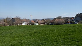
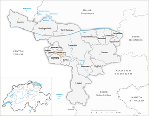
Oberwil is a former municipality and a settlement of the municipality of Gachnang in the Frauenfeld district of the canton of Thurgau in Switzerland .
geography
Oberwil lies on a gentle slope between Frauenfeld and Gachnang.
Church reform in 1998
From 1816 to 1997 Mesenriet, Oberwil and Rosenhuben formed the municipality of Oberwil, which is part of the Gachnang municipality. On January 1, 1998 , the Niederwil community merged as part of the Thurgau community reform to form the political community of Gachnang. At the same time, the districts of Zelgli and Schönenhof were separated from the local community of Oberwil and incorporated into the unified community of Frauenfeld.
history
The place was first mentioned in 1297 as Obernwile , when Duke Albrecht I of Austria allowed Vogt Jakob Hofmeister von Frauenfeld to sell a farm in Oberwil to the Töss Monastery in 1297 . In 1345 the abbot von Reichenau lent two farms in Oberwil to Hans von Gachnang. Oberwil later belonged to the Reichenau office of Frauenfeld. After 1460 Oberwil came to the city of Frauenfeld and was subordinate to its Vogt in Strass until 1798 . Ecclesiastically, Oberwil always shared the fate of the parish of Gachnang. The residents cultivated fields, meadows and fruit. After 1920 the farming village developed into an agglomeration community of Frauenfeld.
population
| year | 1850 | 1900 | 1950 | 1990 | 2000 | 2010 | 2018 |
| Local parish | 218 | 186 | 205 | 399 | |||
| settlement | 55 | 61 | 60 | ||||
| source | |||||||
Attractions
Two former granaries are included in the list of cultural assets in Gachnang .
literature
Erich Trösch: Oberwil (TG). In: Historical Lexicon of Switzerland .
This article is largely based on the entry in the Historisches Lexikon der Schweiz (HLS), which, according to the HLS's usage information, is licensed under the Creative Commons - Attribution - Distribution under the same conditions 4.0 International (CC BY-SA 4.0) license .
Individual evidence
- ↑ Swiss land use statistics. Completed on July 1, 1912. Published by the Federal Statistical Bureau. ( Memento from April 12, 2016 in the Internet Archive )
- ^ Erich Trösch: Oberwil (TG). In: Historical Lexicon of Switzerland .
- ↑ Locations and Settlements Directory. Canton of Thurgau, 2005 edition . On the website of the Statistical Office of the Canton of Thurgau (PDF; 1.7 MB), accessed on April 28, 2020.
- ↑ Locations and Settlements Directory. Canton of Thurgau, 2012 edition. On the website of the Statistical Office of the Canton of Thurgau (PDF; 3.4 MB), accessed on May 11, 2020.
- ↑ List of settlements. Canton of Thurgau, edition 2019 . On the website of the Statistical Office of the Canton of Thurgau (Excel table; 0.2 MB), accessed on May 10, 2020.


