Niederwil TG
| TG is the abbreviation for the canton of Thurgau in Switzerland and is used to avoid confusion with other entries of the name Niederwil . |
| Niederwil | ||
|---|---|---|
| State : |
|
|
| Canton : |
|
|
| District : | Frauenfeld | |
| Political community : | Gachnang | |
| Postal code : | 8547 | |
| former BFS no. : | 4575 | |
| Coordinates : | 707 124 / 268 091 | |
| Height : | 404 m above sea level M. | |
| Area : | 2.59 km² | |
| Residents: | 347 (1990) | |
| Population density : | 134 inhabitants per km² | |
|
Niederwil TG |
||
| map | ||
|
|
||
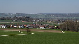
Niederwil is a former municipality and a settlement of the municipality of Gachnang in the Frauenfeld district of the canton of Thurgau in Switzerland .
The local community comprised Niederwil and the hamlets of Bethelhausen and Strass and belonged to the municipal community of Gachnang. On January 1, 1998 , the Niederwil municipality merged to form the political municipality of Gachnang.
geography
The village of Niederwil is located west of Frauenfeld between the Winterthur – Romanshorn railway line and the A 7 Winterthur – Kreuzlingen motorway . Bethelhausen and Strass, however, are north of the A7.
history
Pre-Roman times
In 1862 prehistoric settlement remains were discovered in the Egelsee, the former peat bog north of Niederwil, in the course of intensive peat use . Jakob Messikommer , who carried out several excavations until 1884, made the station known overseas. In-depth scientific investigations were only carried out in 1962/63 by a Dutch research team from the University of Groningen under the direction of Harm Tjalling Waterbolk . The one-period settlement of Niederwil belongs to the Pfyner culture and, according to dendrochronological dating, dates from approx. 3660 to shortly after 3585 BC. At the time of its greatest expansion, the oval-shaped village area extended over an area of around 2000 m² and was safely surrounded by a defensive palisade fence in the final phase . The arrangement in six rows of houses made up of houses assembled at the end is striking.
Based on the examined parts of the settlement, Waterbolk reckons with around 35 usually two-room buildings with an average of 11 meters in length and 5 meters in width. The house floors usually consisted of cross-laid logs or split boards resting on a threshold grate. Up to 15 renovation phases can be documented locally, which corresponds to an average lifespan of the house floors of less than five years. There are only a few references to the construction of the superstructure of the houses. After that, the walls should have consisted of horizontally lying planks , which were fixed to rammed outer posts about 1 meter apart. The excellently preserved wood artefacts stand out from the found material and contributed significantly to today's knowledge of the Neolithic wood industry.
local community
The place was first mentioned in 1337 as Niderenwille . Niederwil, Bethelhausen and Strass belonged in the 13th century to the Kyburg , later Habsburg servants from Strass, who probably owned a residential tower made of large stones, mentioned in the 12th and 13th centuries . They later moved to Frauenfeld, where they built the Strasshof. Around 1390 the high and low jurisdiction fell to Frauenfeld and remained there until 1798. Niederwil was always part of the church after Gachnang and shared its fate.
Peat was extracted in Niederwil. In the 19th century they operated a quarry and from 1850 to 1880 they farmed leeches. A cheese dairy was founded in 1900. At the beginning of the 21st century, the rural village (meadow and fruit growing) owned Ricoter AG, a recycling company, a paint and varnish factory and a company for alarm systems. The new single-family housing estates are increasingly growing into the landscape.
population
| year | 1831 | 1850 | 1900 | 1950 | 1990 | 2000 | 2010 | 2018 |
| Local parish | 234 | 241 | 224 | 216 | 347 | |||
| settlement | 48 | 59 | 135 | |||||
| source | ||||||||
Attractions
The prehistoric lakeside settlement of Egelsee and the former Strass warehouse are included in the list of cultural assets in Gachnang .
literature
- OH Harsena: The Neolithic bog settlement in the Egelsee near Niederwil. In: Thurgauer Jahrbuch , Vol. 39, 1964, pp. 7-30. ( e-periodica.ch )
- Albin Hasenfratz, Erich Trösch: Niederwil (TG). In: Historical Lexicon of Switzerland .
This article is largely based on the entry in the Historisches Lexikon der Schweiz (HLS), which, according to the HLS's usage information, is licensed under the Creative Commons - Attribution - Distribution under the same conditions 4.0 International (CC BY-SA 4.0) license .
Individual evidence
- ↑ Swiss land use statistics. Completed on July 1, 1912. Published by the Federal Statistical Bureau. ( Memento from April 12, 2016 in the Internet Archive )
- ^ Albin Hasenfratz, Erich Trösch: Niederwil (TG). In: Historical Lexicon of Switzerland .
- ↑ Gachnang - Niederwil UNESCO World Heritage , on archaeologie.tg.ch, accessed on March 21, 2020
- ↑ Locations and Settlements Directory. Canton of Thurgau, 2005 edition . On the website of the Statistical Office of the Canton of Thurgau (PDF; 1.7 MB), accessed on April 28, 2020.
- ↑ Locations and Settlements Directory. Canton of Thurgau, 2012 edition. On the website of the Statistical Office of the Canton of Thurgau (PDF; 3.4 MB), accessed on May 11, 2020.
- ↑ List of settlements. Canton of Thurgau, edition 2019 . On the website of the Statistical Office of the Canton of Thurgau (Excel table; 0.2 MB), accessed on May 10, 2020.


