
Warth TG
| TG is the abbreviation for the canton of Thurgau in Switzerland and is used to avoid confusion with other entries of the name Warth . |
| Warth | ||
|---|---|---|
 |
||
| State : |
|
|
| Canton : |
|
|
| District : | Frauenfeld | |
| Political community : | Warth-Weiningen | |
| Postal code : | 8532 | |
| former BFS no. : | 4618 | |
| Coordinates : | 707 973 / 271 477 | |
| Height : | 438 m above sea level M. | |
| Area : | 2.86 km² | |
| Residents: | 664 (December 31, 2018) | |
| Population density : | 232 inhabitants per km² | |
 Parish before the merger in 1995 |
||
| map | ||
|
||

Warth is a village in the municipality of Warth-Weiningen in the Frauenfeld district of the canton of Thurgau in Switzerland . Warth is on the right side of the Thurtal north of Frauenfeld .
From 1803 to 1994 Warth was a local parish of the municipality of Uesslingen . On January 1, 1995 , the local parishes of Warth and Weiningen merged to form the political municipality of Warth-Weiningen.
history

The place was first mentioned in 1420 as Wart . An opening dates from 1420. The Carthusian monastery Ittingen ruled from 1461 to 1798.
Warth belonged to the parish church of Uesslingen until it was incorporated into the provost of Ittingen in 1162 . After the prior had denied the women of Warth access to the Carthusian Church in 1461, they forced the monastery to have their own place of worship. Construction of the St. Wolfgang Chapel, later St. Martin's Church, began in 1471. After the Reformation , Warth returned to Catholicism in 1581, and in 1833 it formed its own parish.
In Warth arable, wine and fruit growing was operated. The monastery mill remained in operation until 1882. In 1979 the school communities of Warth and Weiningen united , in 1989 they built a school with a multi-purpose hall. From 1980, Warth changed to a residential community due to its proximity to Frauenfeld.
coat of arms
Blazon : In white with black rust.
The rust is the symbol of St. Laurentius, the church patron of Ittingen. The colors black and white indicate that it belongs to the jurisdiction of the former Ittingen Charterhouse.
population
| year | 1831 | 1850 | 1900 | 1950 | 1990 | 2000 | 2010 | 2018 |
| Local parish | 225 | 238 | 183 | 219 | 506 | |||
| Locality | 519 | 273 | 664 | |||||
| source | ||||||||
Of the total of 664 inhabitants of the village of Warth in 2018, 60 or 9.0% were foreign nationals. 267 (40.2%) were Protestant Reformed and 234 (35.2%) were Roman Catholic.
Attractions
The Kartause Ittingen is a former Carthusian monastery and today serves as a culture and seminar center as well as a home for the disabled. The Church of St. Martin is located above the vineyards in a panoramic position near the Ittingen Charterhouse. The Lenzberg house was built in 1825 for Chief Justice Dr. Lenz built. The Ittingen Charterhouse is listed in the inventory of Swiss sites worthy of protection .
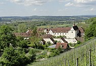
Ittingen Charterhouse view

St. Martin Church

Farmhouse violins
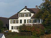
Lenzberg residential building


Web links
Individual evidence
- ↑ Swiss land use statistics. Completed on July 1, 1912. Published by the Federal Statistical Bureau. ( Memento from April 12, 2016 in the Internet Archive )
- ↑ a b c d Localities and their resident population. Edition 2019 . On the website of the Statistical Office of the Canton of Thurgau (Excel table; 0.1 MB), accessed on April 28, 2020.
-
↑ a b c d
Erich Trösch: Warth (TG). In: Historical Lexicon of Switzerland .
These sections are largely based on the entry in the Historical Lexicon of Switzerland (HLS), which, according to the HLS's usage information, is under the Creative Commons license - Attribution - Share under the same conditions 4.0 International (CC BY-SA 4.0). - ↑ a b municipal coat of arms . On the website of the State Archives of the Canton of Thurgau, accessed on December 8, 2019
- ↑ Locations and Settlements Directory. Canton of Thurgau, 2005 edition . On the website of the Statistical Office of the Canton of Thurgau (PDF; 1.7 MB), accessed on April 28, 2020.
- ↑ Locations and Settlements Directory. Canton of Thurgau, 2012 edition. On the website of the Statistical Office of the Canton of Thurgau (PDF; 3.4 MB), accessed on May 11, 2020.
Remarks
- ↑ without outside courtyards
Basadingen-Schlattingen | Berlingen | Diessenhofen | Eschenz | Felben-Wellhausen | Frauenfeld | Gachnang | Herdern | Homburg | Hüttlingen | Hüttwilen | Mammers | Matzingen | Muellheim | Nine-shape | Pfyn | Schlatt | Steckborn | Stettfurt | Thundorf | Uesslingen book | Wagenhausen | Warth-Weiningen
Former municipalities: Basadingen | Book near Frauenfeld | Dettighofen | Eschikofen | Fahrhof | Felben | Gerlikon | Gündelhart-Hörhausen | Harenwilen | Herten | Horgenbach | Huben | Islikon | Kaltenbach | Kefikon | Kurzdorf | Langdorf | Langenhart | Lance neunforn | Lustdorf | Mett-Oberschlatt | Mettendorf | Niederneunforn | Niederwil | Walnut trees | Oberneunforn | Oberwil | Rheinklingen | Salen-Reutenen | Schlattingen | Uerschhausen | Uesslingen | Subdivision | Warth | Weiningen | Wellhausen | Wetzikon | Wilen bei Neunforn | Willisdorf
Canton of Thurgau | Districts of the Canton of Thurgau | Municipalities of the Canton of Thurgau