
Hüttlingen TG
| TG is the abbreviation for the canton of Thurgau in Switzerland and is used to avoid confusion with other entries of the name Hüttlingen . |
| Huettlingen | |
|---|---|
 |
|
| Country: |
|
| Canton : | Thurgau (TG) |
| District : | Frauenfeld |
| Postal code : | 8553 |
| BFS no. : | 4590 (Political Community) |
| former BFS no .: | 4583 (local parish ) |
| Coordinates : | 716201 / 271436 |
| Height : | 411 m above sea level M. |
| Area : | 11.60 km² (pol. Municipality) 3.48 km² (local municipality) |
| Residents: | 850 (December 31, 2018) |
| Population density : | 73 inhabitants per km² |
| Website: | www.www.huettlingen.ch |
 Huettlingen |
|
| map | |
  |
|
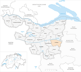
Hüttlingen is a village and a political municipality in the Frauenfeld district in the canton of Thurgau in Switzerland . The former local church Huettlingen formed until 1998, along with the local congregations Eschikofen , Harenwilen and Mettendorf the Munizipalgemeinde Hüttlingen.
geography
Hüttlingen is located at the foot of the northern slope of the Wellenberg on the main road Frauenfeld - Weinfelden . Together with Mettendorf it has a stop on the Winterthur – Romanshorn railway line .
history

Hutlingen was first mentioned in a document in 1336. In the early Middle Ages , Hüttlingen was a richau fief . In 1360 it belonged to the Lords of Wellenberg. The Lower Court of Hüttlingen was separated from the Wellenberg rule in 1608. Johann Kaspar Escher acquired the rule in 1674 and Hüttlingen Castle. From 1694 to 1798 Hüttlingen was owned by the City of Zurich , which had the Lower Court administered from the Wellenberg Castle by a senior bailiff.
Originally, Hüttlingen was in the Pfyn parish , later in that of Müllheim . The St. Andreas chapel in Hüttlingen is documented in 1337. The parish was established in 1484. Eschikofen, Harenwilen and Mettendorf joined the reformed Hüttlingen in 1531.
In the 19th century dairy farming and cattle breeding emerged alongside arable and fruit growing, while viticulture was abandoned in the 20th century. Although agricultural use has recently been marginalized, around a third of the workforce in Hüttlingen still worked in the first economic sector in 2000 .
On January 1, 1999, the municipality of Hüttlingen merged with the local communities of Eschikofen, Harenwilen, Hüttlingen and Mettendorf to form the political municipality of Hüttlingen.
coat of arms
Local parish

Blazon : A white St. Andrew's cross in blue .
The origin of the coat of arms goes back to the church of Hüttlingen, consecrated to St. Andrew . The colors blue and white indicate the relationship with the city of Zurich.
Political community
Blazon : Divided by blue with a white, striding lion and white-red chess .
The coat of arms comes from the former local community of Mettendorf .
→ see section coat of arms in the article Mettendorf TG
population
 |
| 1850 | 1900 | 1950 | 1990 | 2000 | 2010 | 2018 | |
|---|---|---|---|---|---|---|---|
| Political community | 839 | 821 | 843 | ||||
| Municipal parish | 724 | 622 | 684 | 646 | |||
| Local parish | 206 | 182 | 202 | 201 | |||
| source | |||||||
Of the total of 1,542 inhabitants in the municipality of Homburg in 2018, 128 or 8.3% were foreign nationals. 642 (41.6%) were Protestant Reformed and 527 (34.2%) were Roman Catholic. At that time, Homburg had 856 residents.
economy
In 2016, Hüttlingen offered work for 160 people (converted to full-time positions). Of these, 37.7% were employed in agriculture and forestry, 30.7% in industry, trade and construction and 31.5% in the service sector.
politics
The municipal council of Hüttlingen consists of 5 members and is elected every 4 years. One representative from each of the four former local congregations sits on the local council.
Attractions
Hüttlingen is listed in the inventory of places worthy of protection in Switzerland .

Tavern "Sun"

Geeregass house 7

Mill

Hüttlingen Castle


Personalities
- Johann Jacob Wehrli (1790 in Eschikofen - 1855), educator
Web links
Individual evidence
- ↑ a b Thurgau in figures 2019 . On the website of the Statistical Office of the Canton of Thurgau (PDF file; 1.8 MB), accessed on April 28, 2020.
- ↑ Swiss land use statistics. Completed on July 1, 1912. Published by the Federal Statistical Bureau. ( Memento from April 12, 2016 in the Internet Archive )
- ↑ Permanent and non-permanent resident population by year, canton, district, municipality, population type and gender (permanent resident population). In: bfs. admin.ch . Federal Statistical Office (FSO), August 31, 2019, accessed on December 22, 2019 .
- ↑ a b Localities and their resident population. Edition 2019 . On the website of the Statistical Office of the Canton of Thurgau (Excel table; 0.1 MB), accessed on April 28, 2020.
-
↑ a b c d
Verena Rothenbühler: Hüttlingen. In: Historical Lexicon of Switzerland .
These sections are largely based on the entry in the Historical Lexicon of Switzerland (HLS), which, according to the HLS's usage information, is under the Creative Commons license - Attribution - Share under the same conditions 4.0 International (CC BY-SA 4.0). - ↑ Mutation No. 44d to the official register of municipalities in Switzerland, 1986
- ↑ a b coat of arms. On the website of the municipality of Hüttlingen, accessed on December 29, 2019
- ↑ a b municipal coat of arms . On the website of the State Archives of the Canton of Thurgau, accessed on December 8, 2019
- ↑ a b Population development of the municipalities. Canton Thurgau, 1850–2000 and resident population of the municipalities and change from the previous year. Canton of Thurgau, 1990–2018. On the website of the Statistical Office of the Canton of Thurgau (Excel tables; 0.1 MB each), accessed on April 28, 2020.
Basadingen-Schlattingen | Berlingen | Diessenhofen | Eschenz | Felben-Wellhausen | Frauenfeld | Gachnang | Herdern | Homburg | Hüttlingen | Hüttwilen | Mammers | Matzingen | Muellheim | Nine-shape | Pfyn | Schlatt | Steckborn | Stettfurt | Thundorf | Uesslingen book | Wagenhausen | Warth-Weiningen
Former municipalities: Basadingen | Book near Frauenfeld | Dettighofen | Eschikofen | Fahrhof | Felben | Gerlikon | Gündelhart-Hörhausen | Harenwilen | Herten | Horgenbach | Huben | Islikon | Kaltenbach | Kefikon | Kurzdorf | Langdorf | Langenhart | Lance neunforn | Lustdorf | Mett-Oberschlatt | Mettendorf | Niederneunforn | Niederwil | Walnut trees | Oberneunforn | Oberwil | Rheinklingen | Salen-Reutenen | Schlattingen | Uerschhausen | Uesslingen | Subdivision | Warth | Weiningen | Wellhausen | Wetzikon | Wilen bei Neunforn | Willisdorf
Canton of Thurgau | Districts of the Canton of Thurgau | Municipalities of the Canton of Thurgau