Book at Frauenfeld
| Book at Frauenfeld | ||
|---|---|---|
| State : |
|
|
| Canton : |
|
|
| District : | Frauenfeld | |
| Political community : | Uesslingen book | |
| Postal code : | 8524 | |
| former BFS no. : | 4616 | |
| Coordinates : | 705 332 / 273 175 | |
| Height : | 463 m above sea level M. | |
| Area : | 6.82 km² | |
| Residents: | 340 (December 31, 2018) | |
| Population density : | 50 inhabitants per km² | |
|
Book at Frauenfeld |
||
| map | ||
|
|
||
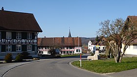
Buch bei Frauenfeld is a village in the municipality of Uesslingen-Buch and was a municipality in the Swiss canton of Thurgau from 1803 to 1994 .
The local community was called Buch bei Uesslingen until 1953 and was part of the municipal community Uesslingen with the local communities Buch bei Frauenfeld, Uesslingen and Warth . With the Thurgau community reform , Buch near Frauenfeld and Uesslingen merged in 1995 to form the political community of Uesslingen-Buch .
geography
The farming village of Buch is located south of the three Hüttwilerseen in a gentle hollow and includes Buch and the hamlets of Trüttlikon, Hueb and Horben. In the village itself there is a restaurant and Buch's only grocery store owned by the Buch community.
The Hasensee , which is located near the village, belongs to the district of the former municipality of Buch .
history
The hamlet of Trüttlikon was first mentioned in 1155 as Truchtelincofen . A farm in Buch is occupied from around 1130 and mentioned as Buoch in 1260 .
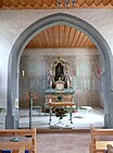
Buch bei Frauenfeld was in the court of the Ittingen Monastery from the Middle Ages until 1798 and has belonged to the parish of Uesslingen since the Middle Ages . A chapel should have existed from the 11th century. Its successor, the Sebastian Chapel, which was probably built around 1300, became famous for the high Gothic frescoes discovered in 1938 .
Agriculture is the most important industry. Viticulture was important up to the 19th century, in the 20th century the dairy industry with the cheese cooperative founded in 1912, as well as fruit and arable farming. In 1990, 73% of the employed in books were employed in the first economic sector. In 1980 a comprehensive improvement was carried out.
coat of arms
Blazon : In white with two crossed black arrows with white blood channels .
The arrows point to the center of Buch, the chapel dedicated to St. Sebastian. The colors black and white reveal the former belonging to the judiciary of the Ittingen Charterhouse.
population
| Population development Buch bei Frauenfeld | |||||||
|---|---|---|---|---|---|---|---|
| year | 1850 | 1900 | 1950 | 1990 | 2000 | 2010 | 2018 |
| Local parish | 380 | 305 | 331 | 333 | |||
| Locality | 170 | 200 | 340 | ||||
| source | |||||||
Of the total of 340 inhabitants in the village of Buch bei Frauenfeld in 2018, 16 or 4.7% were foreign nationals. 170 (50.0%) were Protestant Reformed and 102 (30.0%) Roman Catholic.
Attractions
The oldest building in Buch is the Sebastian Chapel. It was first mentioned in a document in 1461, but it is many centuries older. The Gothic wall paintings were created around 1320 and show various images of the Passion and the glorification of Christ. These frescoes were rediscovered and restored during the renovation of the chapel in 1938. The chapel is under federal monument protection and is listed in the list of cultural assets in Uesslingen-Buch .
The hamlet of Trüttlikon is listed in the inventory of places worth protecting in Switzerland . The Helfenberg ruin is on the way to Hüttwilersee.
Web links
Individual evidence
- ↑ Swiss land use statistics. Completed on July 1, 1912. Published by the Federal Statistical Bureau. ( Memento from April 12, 2016 in the Internet Archive )
- ↑ a b c d Localities and their resident population. Edition 2019 . On the website of the Statistical Office of the Canton of Thurgau (Excel table; 0.1 MB), accessed on April 28, 2020.
- ↑ Population development of the municipalities. Canton of Thurgau, 1850-2000. On the website of the Statistical Office of the Canton of Thurgau (Excel table; 0.1 MB), accessed on April 28, 2020.
-
↑ a b c d e Gregor Spuhler : Book near Frauenfeld. In: Historical Lexicon of Switzerland . These sections are largely based on the entry in the Historical Lexicon of Switzerland (HLS), which, according to the HLS's usage information, is under the Creative Commons license - Attribution - Share under the same conditions 4.0 International (CC BY-SA 4.0).
- ↑ a b municipal coat of arms . On the website of the State Archives of the Canton of Thurgau, accessed on December 8, 2019
- ↑ Locations and Settlements Directory. Canton of Thurgau, 2005 edition . On the website of the Statistical Office of the Canton of Thurgau (PDF; 1.7 MB), accessed on April 28, 2020.
- ↑ Locations and Settlements Directory. Canton of Thurgau, 2012 edition. On the website of the Statistical Office of the Canton of Thurgau (PDF; 3.4 MB), accessed on May 11, 2020.
Remarks
- ↑ with outside courtyards


