
Fahrhof
| Fahrhof | ||
|---|---|---|
| State : |
|
|
| Canton : |
|
|
| District : | Frauenfeld | |
| Political community : | Nine-shape | |
| Postal code : | 8525 | |
| Coordinates : | 699 134 / 272 734 | |
| Height : | 390 m above sea level M. | |
| Residents: | 34 (December 31, 2010) | |
| map | ||
|
||


Fahrhof is a hamlet in the municipality of Neunforn in the Frauenfeld district of the canton of Thurgau in Switzerland . Fahrhof is located between Ossingen and Niederneunforn not far from the canton border and the Thur .
The hamlet Fahrhof formed an independent local community in the municipal municipality of Neunforn from 1843 to 1869 , while before and after it belonged to the former local municipality of Oberneunforn , which was merged into the political municipality of Neunforn in 1996 .
history
In 1254 the Töss monastery acquired real estate and rights in Fahrhof; the settlement was first mentioned as Vare . From the late Middle Ages until 1798 the settlement was part of the Oberneunforn Lower Court.
The Fahrhof, which has been reformed by the majority since the Reformation in 1525, has always belonged to the parish of Neunforn. Until 1776/79 Fahrhof ran a joint school with the neighboring Zurich hamlet Burghof (municipality of Ossingen ).
In the 19th century the transition to dairy and livestock farming as well as fruit growing took place. Viticulture, which was abandoned in the 19th century, has regained importance in the settlement, which is still dominated by farmers today.
population
| year | 1850 | 1860 | 2000 | 2010 |
| Residents | 55 | 61 | 29 | 34 |
| source | ||||
Attractions
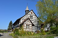
The hamlet of Fahrhof is listed in the inventory of places worth protecting in Switzerland , the old school building in the list of cultural assets in Neunforn .
photos

Entrance

Fahrhof
Old school house
_(15).JPG)
_(22).JPG)
_(20).JPG)
Web links
literature
- Verena Rothenbühler: Fahrhof. In: Historical Lexicon of Switzerland .
This article is largely based on the entry in the Historisches Lexikon der Schweiz (HLS), which, according to the HLS's usage information, is licensed under the Creative Commons - Attribution - Distribution under the same conditions 4.0 International (CC BY-SA 4.0) license .
Individual evidence
- ↑ a b List of localities and settlements. Canton of Thurgau, 2012 edition. On the website of the Statistical Office of the Canton of Thurgau (PDF; 3.4 MB), accessed on May 11, 2020.
- ↑ Locations and Settlements Directory. Canton of Thurgau, 2005 edition . On the website of the Statistical Office of the Canton of Thurgau (PDF; 1.7 MB), accessed on April 28, 2020.
Basadingen-Schlattingen | Berlingen | Diessenhofen | Eschenz | Felben-Wellhausen | Frauenfeld | Gachnang | Herdern | Homburg | Hüttlingen | Hüttwilen | Mammers | Matzingen | Muellheim | Nine-shape | Pfyn | Schlatt | Steckborn | Stettfurt | Thundorf | Uesslingen book | Wagenhausen | Warth-Weiningen
Former municipalities: Basadingen | Book near Frauenfeld | Dettighofen | Eschikofen | Fahrhof | Felben | Gerlikon | Gündelhart-Hörhausen | Harenwilen | Herten | Horgenbach | Huben | Islikon | Kaltenbach | Kefikon | Kurzdorf | Langdorf | Langenhart | Lance neunforn | Lustdorf | Mett-Oberschlatt | Mettendorf | Niederneunforn | Niederwil | Walnut trees | Oberneunforn | Oberwil | Rheinklingen | Salen-Reutenen | Schlattingen | Uerschhausen | Uesslingen | Subdivision | Warth | Weiningen | Wellhausen | Wetzikon | Wilen bei Neunforn | Willisdorf
Canton of Thurgau | Districts of the Canton of Thurgau | Municipalities of the Canton of Thurgau